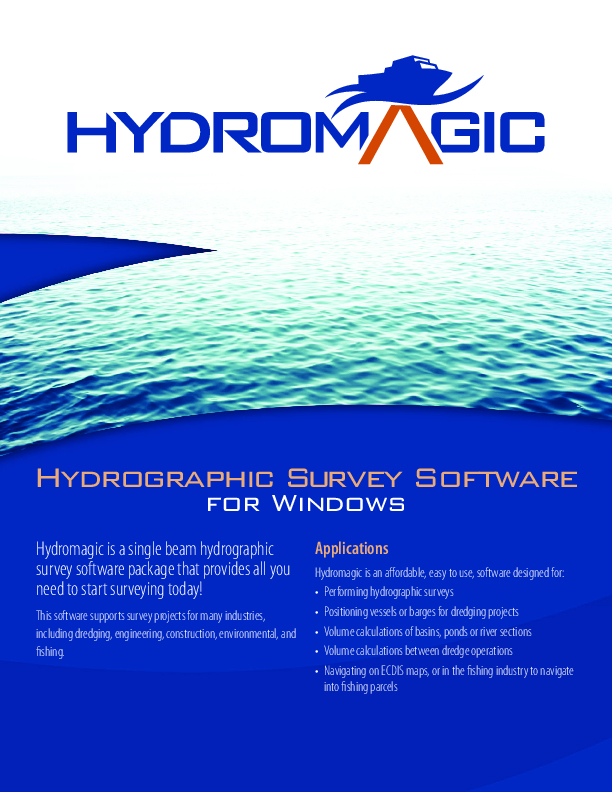
Hydromagic Survey
Eye4Software Hydromagic Survey is a cost-effective, easy to use hydrographic data acquisition and processing software package for Windows. The software has a short learning curve and has been designed to allow both experienced and novice (non-surveyor) users to perform hydrographic data acquisition and produce final products from a single software package. The package contains tools for data acquisitions, as well as tools for data cleansing, echogram digitizing, processing and exporting.

Eye4Software
Wolvega, NL
Description
Hydromagic is a single beam hydrographic survey software package that provides all you need to start surveying today!
Do you have questions about this product?
- Questions about price, availability, and/or retailers
- Questions about technical specifications and usage
- Questions about suitability for your project or application
Specifications
-
Hardware/software requirements
-
RAM [MB]
2048
HD{GB}
32
Use of GPU
Y
Processor
["32-bit","64-bit"]
Stereo Display
N
Field of Use
Hydrographic Survey
Languages Supported
English
-
General
-
Year of last update
2021
Year of initial introduction
2009
Modules
Survey
Supported Systems (SB, MB, SSS, Lidar etc.)
SB, SSS
-
Processing
-
Sound velocity correction
Single profile support
Sound velocity correction type
Time
Tidal reduction
RTK-tide, Tide
Support tidal reduction network
Y
Gridding/Interpolation techniques
TIN, Nearest Neighbour, Bilineair
Grid attributes {Std., Mean, Max, etc.}
STD
Lay-back correction
N
Siant range correction
Y
Mosaic creation
Y
Mosaic creation algorithms
N/A
SSS Targeting
N/A
Video integration
N
Number of video channels
0
Assessment of bathymetry IHO Cat S-44
N
Type of automatic cleaning algorithm(s)
Manual, Median, Mean, Clip Above, Clip Below
Multibeam water column imaging support
N
Multibeam Backscatter Processing Functionality
N/A
Manual editing capability
Y
Mulitbeam Calibration mehods
-
Geodetic Functionality
-
Supported coordinate systems
Universal Transverse Mercator, State Plane Coordinate System, Tranverse Mercator, Lambert Conformal Conic, Oblique Sterographic, Polar Stereographic, Albers Equal Area, Bonne, Cassini Soldner, Krovak, Mercator, Polyconic, Oblique Mercator and more.
Geographical Coordinates {Lat, Long}
Y
Ground Coordinates {E,N}
Y
Seven Parameter shift supported
Y
Supported vertical reference frames
Many including NAVD88
Separation model for vertical datum shift support
Y
Local datum support
Y
Ellipsoidal reference support (GRS80)
Y
-
Product Generation
-
Automatic top of pipe calculation
N
Slope analysis
Y
Dynamic event numbering
Y
Automatic cross profile creation
Y
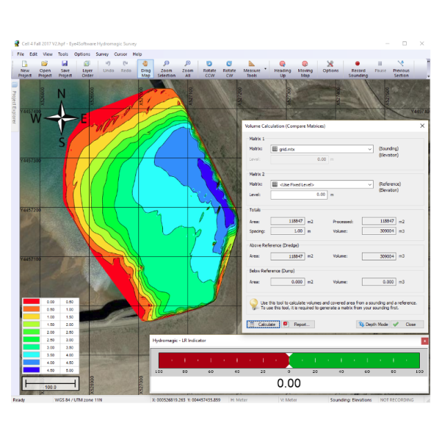
Volume calculation
Y
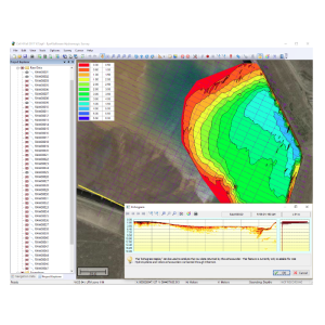
Contouring
Y
Sounding Selection methods
Y
Export/Exchange options
ASCII, XYZ, XTF, SEG-Y, AutoCAD DXF, PDF, PNG, GIF, JPG, ESRI Shape Files and Keyhole Markup Language (KML)
Combining bathymetry / terrestrial point clouds
Y
-
Visualisation and Editing
-
2D Editing
Y
2D Visualization
Y
Fly-throughs support
N
Area based 3D editing
N
Area based 3D View
Y
3D View max number points
Unlimited
3D Integrated models
NO
Sounding cleaning algorithms
Averaging, Median, Filter
4D support
N
4D fly through movies {*.mov etc.}
N/A
-
Files and Registering
-
Input Formates {XTF, XYZ, GSF etc}
SEG-Y, XYZ, XTF, ASCII, GPX, CEE HydroSystems, Kongsberg RAW, Odom, Imagenex, SES2000 and NMEA0183
Max. Number of Soundings
Unlimitied
Supported Hydrographic Systems
Single Beam (Dual Frequency), Side Scan Sonar
Background format support {Google, Bing, OGC, CAD etc.}
Google Maps, Bing Maps, Georeferenced PNG/JPG/BMP/GIF images, IHO S(ENC), AutoCAD DXF, Microstation DGN, (Geo)TIFF, ESRI Shapefiles, ARC/Info, MapInfo, Atlas BNA, Idrisi, DLG-3, DLG-O, KML, OpenStreeMap XML,
Documents
Brochure
14070-hydromagic-data-sheet.pdf
1.11 MB
Other documents
-
Product Manual (23)7.5 MB
More from Eye4Software