
HY1600
Description
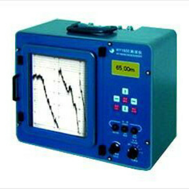
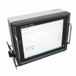
HY1600 is a portable, precision survey echosounder for surveying in inland water, rivers, coastal areas and in other rugged conditions.
Do you have questions about this product?
- Questions about price, availability, and/or retailers
- Questions about technical specifications and usage
- Questions about suitability for your project or application
Specifications
-
General
-
Year of initial development
2002
Max. power consumption [W]
30
Min. external DC power [V]
10
Max. external DC power [V]
25
Min. external AC power [V]
180
Max. external AC power [V]
260
Weight in air [kg]
1.5
Width [m]
0.08
Length [m]
0.08
Height [m]
0.08
-
System integration
-
Remote operation capability
Y
Supported external data inputs
heave, position
Marking of events and other annotations
Y
Real-time sound velocity and temperature profile inclusion
N
Real-time coupling to survey/post-processing software
Y
Data displayed in real time
Depth
-
Mode of operation
-
Software platform
Other
Min. depth of operation [m]
0.3
Max. depth of operation [m]
300
Min. frequency [kHz]
24
Max. frequency [kHz]
208
Number of simultaneous frequencies
1
Standard power output [W]
100
Min. beam angle [deg]
8
Max. beam angle [deg]
8
Depth resolution [m]
0.01
Depth-dependent uncertainty [%]
0.1
Max. sounding rate [Hz]
20
Min. pulse length [ms]
-0.05
Max. pulse length [ms]
0.4
Dynamic range [dB]
80
-
Other specifications
-
Internal data logging details
Thermal paper
Main use of the system
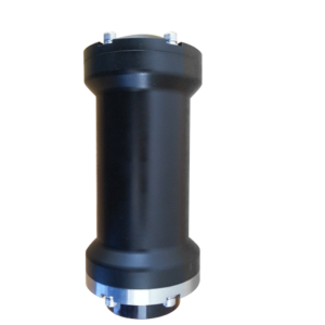
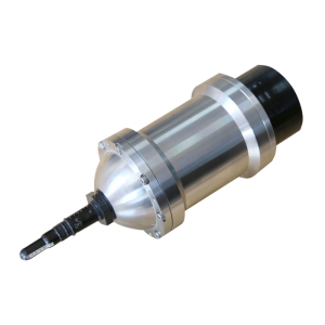
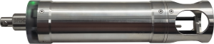
HY1600 is a portable, precision survey echosounder for surveying in inland water, rivers, coastal areas and in other rugged conditions. Digital processing enables the instrument to offer fully automatic bottom digitzing capabilities. The LCD displays a valid digital depth when a firm bottom has been locked. A RS-232/RS485 serial port interfaces to some external computer or GPS system and motion sensors and make the autosurveying possible.Feature of this instrument: Adjustable pulse width / power / sensitivity/TVGDSP Technical / Underwater automatic tracking skillStandard RS232/485 serial data output pairsCan be accessed by DGPS / PC / peripheral swell compensators, etc.Self / keyboard setting parameters / off memory functionThermal recording / LCD Display / manual and automatic commutation functionAutomatic calibration / Note label / time / GPS coordinates / swell valueMain Technical Specifications:Frequency:208KHzSurvey Range:0.3m-300mAccuracy:0.1%Resolution:1cmOutput power:100WPower Req:10VDC-25VDCTransducer:208KHz-8 degRecording: 8.5''/216mm Thermal printer and LCD displayChart speed: auto/1-20cm/min adjustableData Output: 2 ports via RS232/485Phasing: Manual/Auto Scale ChangeWeight: 9.8kgMiscellaneous: AGC/TVG, Auto-mark, Draft/velocity/Blanking adjustableHostDimension:460×360×190mmWeight:12kgTransducerDimension:Φ80×26mmWeight:1.5kgCable Length:10m(adjustable)Measuring rodDimension: 3×0.7mWeight:5kg
-
Output
-
Data output options
Raw data; transducer and motion-corrected depth
Data output formats
DESO 25; Echotrac
Data output for sea floor classification
N
Data display details
Back-lighted graphical LCD module
Connectors
RS232, RS485
-
Logging unit
-
Weight [kg]
9.8
Width [m]
0.4
Length [m]
0.33
Height [m]
0.165
Portability
Desktop, Portable, Rack
More from Wuxi Haiying-Cal Tec Marine Technology