Description
Specifications
-
General
-
Type
Software, Software and ground control points
-
Application and Use
-
Main users
Anyone responsible for supplying or receiving satellite or aerial orthoimagery imagery that must be validated and verified for horizontal and vertical accuracy. CompassAA™ is used by regional planning organizations, local, state and federal governments. From the private sector, several consulting engineering firms who differentiate themselves from their competition by providing a professional, and statistically meaningful data accuracy report as part of their delivery.
Main applications
Validation and verification of satellite or aerial orthoimagery imagery for horizontal and vertical accuracy using photo identifiable ground control points. Final product is a report that is organized and easy to understand. Reports statistical results are based on industry standards.
-
Data/Software specifications
-
Standard data format
CompassAA™ accepts the following data file formats: *** Imagery file formats: GeoTIF, SID, IMG, JPG, JP2, ECW, BIL, BMP *** Ground Control Surveyed Coordinates: TXT or CSV *** Ground Control Suveyed Photos and Sketches: JPG *** Index Tile for Multiple Image projects or for AOI boundary: ESRI shape file *** Report file format: PDF
Data description
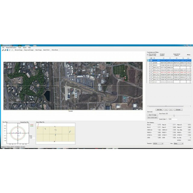
CompassAA™ compares the image derived coordinates in a geo-referenced image with collected ground control data coordinates of the same location. It looks at the pixel coordinates in the image compared to the location of that pixel found from ground control. The software produces consistent, standardized and professional reports. These data verification and validation reports can be customized for data quality requirements. Reports can display different types of error statistics (RMSE, CE90, CE95, NSSDA), a circular error plot, includes photos and diagrams of each point used in the analysis.
Data collection description
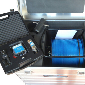
You can use your own ground control or access the largest commercially available ground control data set - GCPArchive. Ground Control Collection The foundation of CompassData’s business is GPS surveying. We currently have an archive of over 36,000 Ground Control Points (GCPs) around the world. http://www.compassdatainc.com/archive.htm These points have been collected for all types of projects and for a variety of customers. We regularly perform survey work for both imagery and LiDAR collects to sub 5 cm x, y, z requirements. Each of our GCPs is provided to the customer with all supporting metadata, context photos, accuracy reports and station diagrams. Increase accuracy and save time and money by designing your project area to coincide with archive GCPs. The GCPs in the CompassData archive have all passed rigorous quality-control procedures. The accuracy of the GCPs are defined as follows; Quality-1: 1cm – 10cm horizontal accuracy, 3cm – 10cm vertical accuracy Quality-2: 10cm - 20cm horizontal accuracy, 10cm - 20cm vertical accuracy Quality-3: 20cm - 50cm horizontal accuracy, 20cm - 75cm vertical accuracy Quality-4: 50cm – 70cm horizontal accuracy, 75cm – 1.25m vertical accuracy Quality-5: 70cm – 2.5m horizontal accuracy, 1.25m – 5m vertical accuracy
Data quality control descripton
CompassAA™ provides several benefits to those who are responsible for orthoimagery data quality. First, the software allows you to easily assess either individual image tiles, AOIs or the overall mosaic. This is useful because you can provide separate accuracy analysis on the different collection areas, and can identify any specific problem areas. Second, the program produces an easy to read report which shows the ground control used to verify the accuracy and areas in the image that have accuracy issues. This would be useful to quickly and easily assess if the orthoimagery deliverables meet the project requirements. CompassAA™ greatly speeds up the analysis and reporting process it allows clients to be very cost competitive in their accuracy analysis. In general, CompassAA™ requires the user to follow a consistent, repeatable, standardized Q/C process by requiring data fields to be completed before proceeding. Each point must be reviewed, photo identified, and then visually validated and verified.
License and ownership description
CompassAA™ currently requires the user to purchase a workstation based license. A annual maintenance fee is required after the first year.
More in Verification and Validation