Description
Specifications
-
General
-
Type
Software
-
Application and Use
-
Main users
Energy suppliers, infrastructure companies, facility management, GIS managers, CAD managers
-
Data/Software specifications
-
Standard data format
DWG, DXF, ESRI Shape, DGN, GPX, GeoMedia, MapInfo... and 300 more!
Data description
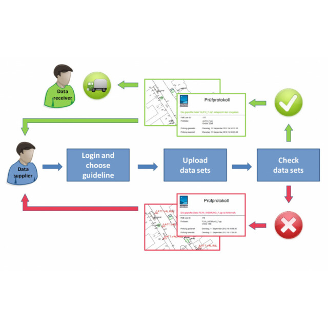
Online data validation service
Data collection description
www.checkgeodata.net
Data quality control descripton
Geodata are usually created according to certain rules, directives, interfaces, data models or application schemas. checkgeodata.net offers an innovate way! Simply check geodata online to see if they comply to your defined specifications. Due to lack of staff and time, stakeholders may not be able to check new data for correctness. This can mean unchecked and possibly incorrect data is incorporated into the organization. The advantages of checkdata.net service are therefore clear. Online checks provide a “proof of accuracy” statement, which is advantageous to both the organization and the contractor: The quality assurance is shifted from the recipient to the data suppliers. Every data supplier is using the same standardized checking routine. The supplier can check his data at any time and is independent. No feedback from the recipient required. The QA process is faster than ever. No installation and update efforts. Before acceptance the recipient can ask for the corresponding checking report generated by checkgeodata.net. With this the quality of the delivered data can be quickly evaluated. checkgeodata.net is a completely new way of quality assurance for geodata and guarantees compliance with specifications on the one hand and a consistent database on the other hand.
License and ownership description
Hosted webservice (rental)
More in Verification and Validation