HYSWEEP OFFICE
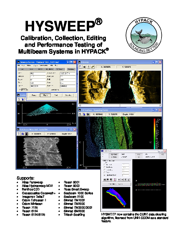
HYSWEEP Is an Optional Module That Provides for the Calibration, Data Collection and Data Processing of Multibeam Sonar Data Inside The HYPACK package
HYSWEEP has been integrated into almost all multibeam systems, including those from Odom, Reson, Kongsberg, Simrad, Elac, Seabeam, and GeoAcoustics. With over 500 HYSWEEP users on six continents, HYSWEEP has proven to be powerful, cost-effective and easy to learn.

HYPACK, A Xylem Brand
Middletown, US
Description
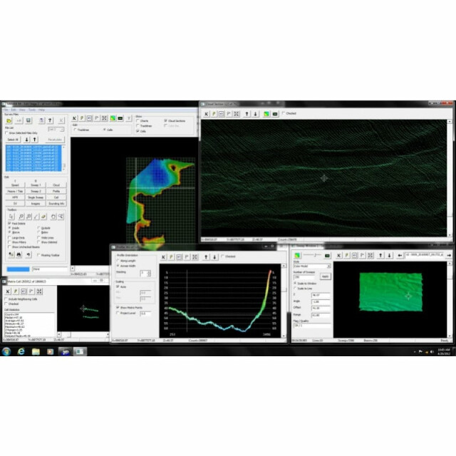
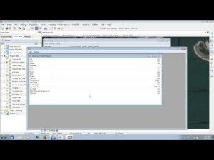
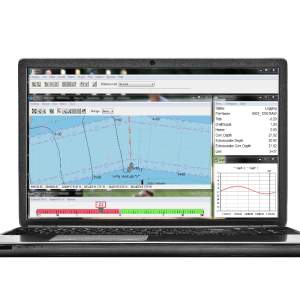
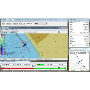
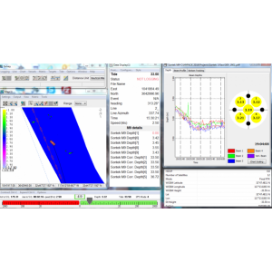
HYSWEEP is an optional module that provides for the calibration, data collection and data processing of multibeam sonar data inside the HYPACK package. HYSWEEP has been integrated into almost all multibeam systems, including those from Odom, Reson, Kongsberg, Simrad, Elac, Seabeam, and GeoAcoustics. With over 500 HYSWEEP users on six continents, HYSWEEP has proven to be powerful, cost-effective and easy to learn.
Do you have questions about this product?
- Questions about price, availability, and/or retailers
- Questions about technical specifications and usage
- Questions about suitability for your project or application
Specifications
-
Hardware/software requirements
-
RAM [MB]
16000
HD{GB}
250
Use of GPU
Y
Processor
["32-bit","64-bit"]
Stereo Display
N
Field of Use
Hydrographic Surveys, Barge Positioning, Construction, Archeology, Navigation, Offhore Surveys, laser surveys, and Dredging
Languages Supported
English, Spanish, French, Russian, and many more!
-
General
-
Year of last update
2022
Year of initial introduction
1991
Modules
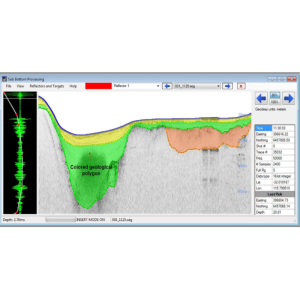
This package contains the multibeam modules that relate to processing of the multibeam, backscatter, LIDAR data and water column. The package is intended for office use.
Supported Systems (SB, MB, SSS, Lidar etc.)
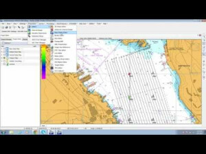
HYSWEEP® OFFICE supports a wide range of equipment systems including: Multibeam, interferometric, SAS, LIDAR., Cameras
-
Processing
-
Sound velocity correction
Multiple profile correction support
Sound velocity correction type
Distance + Time
Tidal reduction
Support tidal reduction network
Y
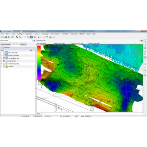
Gridding/Interpolation techniques
TIN and others
Grid attributes {Std., Mean, Max, etc.}
Minimum, Median, Maximum, Average, Center point, Mode, Deepest Mode, Strikes, Count, Z Range, Standard Deviation Sigma, CUBE (Depth, Uncertainty, H Count, Hypothesis, Ratio, Coverage.
Lay-back correction
Y
Siant range correction
Y
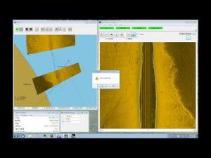
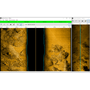
Mosaic creation
Y
Mosaic creation algorithms
Proprietary and Geocoder
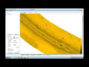
SSS Targeting
Yes
Video integration
Y
Assessment of bathymetry IHO Cat S-44
Y
Type of automatic cleaning algorithm(s)
Minimum, Median, Maximum, Average, Center point, Mode, Deepest Mode, Strikes, Count, Z Range, Standard Deviation Sigma, CUBE (Depth, Uncertainty, H Count, Hypothesis, Ratio, Coverage.
Multibeam water column imaging support
Y
Multibeam Backscatter Processing Functionality
Yes
Mulitbeam Calibration mehods
Automatic and Manual
Manual editing capability
Y
-
Geodetic Functionality
-
Supported coordinate systems
Over 100 International and US pre defined grids, including WGS84, NAD27, Sate Planes (US), Geoid Models, V-Datum, and User Defined.
Geographical Coordinates {Lat, Long}
Y
Ground Coordinates {E,N}
Y
Seven Parameter shift supported
Y
Supported vertical reference frames
Yes
Separation model for vertical datum shift support
Y
Local datum support
Y
Ellipsoidal reference support (GRS80)
Y
-
Product Generation
-
Automatic top of pipe calculation
N
Slope analysis
N
Dynamic event numbering
Y
Automatic cross profile creation
Y
Volume calculation
N
Contouring
N
Sounding Selection methods
Y
Export/Exchange options
XYZ, HS2, GeoTiFF
Combining bathymetry / terrestrial point clouds
Y
-
Visualisation and Editing
-
2D Editing
Y
2D Visualization
Y
Fly-throughs support
Y
3D fly-through movies {*.mov etc}
Y
Area based 3D editing
Y
Area based 3D View
Yes
3D View max number points
Unlimited
3D Integrated models
Yes
Sounding cleaning algorithms
CUBE, SPLINE, Savitsky Golay, Intensity, Deepest
4D support
Y
4D fly through movies {*.mov etc.}
No
-
Files and Registering
-
Input Formates {XTF, XYZ, GSF etc}
RAW, HSX, XYZ, XTF, IMG, CM2, JSF, XSE, GPX, GSF, .83P, .D1P, .81S, .ALL, .MST, .S7K, .SXI, .SXP, .TDY, .SDF, LAS, ASCII, and we can add custom formats.
Max. Number of Soundings
Unlimited and depends on the computer memory.
Supported Hydrographic Systems
HYSWEEP® Office supports a wide range of hydrographic systems including these manufatures: Atlas Bomasweep, Fansweep and Hydrosweep, Benthos, Blueview multibeam, Edgetech, GeoAcoustics GeoSwath, Imagenex Delta T, Kongsberg, Klein HydroChart, Klein, Odom ES3 (Single and Dual Head), Odom MB1 (Single and Dual Head), Odom Echoscan, PingDSP, R2Sonic Sonic, Reson, Ross Smart Sweep, Bathy SwathPlus, Seabeam, Tritech SeaKing, WASSP Multibeam, Riegl LMS and V Series, Optech ILRIS, MDL Dynascan, Reinshaw, Leica PS20.
Background format support {Google, Bing, OGC, CAD etc.}
Web base charts: NOAA Catalog, ACOE Catalog, Bing Maps, USGS Imagery Maps, NASA. Other formats are: BSB Files, ARCS Raster Charts, C-Map Files, DIG Files, DGN Files, DGW Files, DG2 Files, DXF Files, DWG Files, ECW Files, GML Files, MIF Files, JPEG 2000 Files, PDF Files, PNG Files, SHP Files, MR.SID Files, S57 Files, S63 Files, TIF Files, VPF Files.
Documents
Brochure
migrationtge34s.pdf
749.09 KB


