

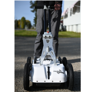
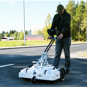
PinPointR Ground Penetrating Radar utility locator
Ground Penetrating Radar Utility Locator
PinPointR, a dedicated GPR utility locator instrument. The PinPointR has been developed to maximize in-field productivity by utilizing ImpulseRadar’s innovative real-time sampling (RTS) dual-channel antenna technology (400 and 800 MHz), which provides incredible bandwidth, speed, and resolution, all controlled via an intuitive Android-driven user interface.
ImpulseRadar
Mala, SE
Description
The ImpulseRadar PinPointR offers a clear and dependable way to quickly and easily locate, avoid or map underground utilities with the functionality required to meet approved industry standards, whilst offering market-leading performance and data quality.
The enhanced bandwidth of the PinPointR antenna provides resolution beyond that of any single-channel GPR system for the detection of near-surface utility targets and other internal reflectors of interest, as well as deeper utility targets with maximum depth penetration.
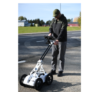
To maximize in-field productivity, PinPointR includes the features and functionality you use day to day in real-world scenarios. Consequently, PinPointR offers complete flexibility for collecting either single line profiles, or multi-line projects with user-defined lengths and profile spacing to suit actual site conditions and your specific utility locate objectives.
IPR Android App&CrossPoint Visualisation Software
The Android data acquisition App includes industry standard marker functionality (APWA, AS5488, or user-defined) to enable users to markup data in the field to correlate with the actual paint marks they put on the ground and any subsequent field sketches or report outputs.
PinPointR data files are compatible with CrossPoint software for Windows-based processing, interpretation, and analysis of GPR data. The user-friendly interface provides practical tools for filter assignment, data processing, marking points of interest within radar profiles, visualizing markers on support maps, and exporting markers for gee-referencing within suitable CAD/GIS platforms.
KEY FEATURES
- ImpulseRadar RTS-based antenna technology
- Internal data security
- Dual-channel operation 400 MHZ (LF) & 800 MHz (HF)
- Integrated GPS, with external GPS support (NMEA 0183 protocol)
- Android-driven interface
- Impressive 7-hour battery life
- Wireless data acquisition
- No survey speed limitation
Specifications
-
General
-
Year of initial introduction
2019
Application Type
Pipes & Cables, Archaelogical & Environmental
Mounting
Carriage
Total weight full configuration (including batteries, Control unit, datalogger, carrier) {kg}
20
Power type
DC
Max Power Consumption {W}
16
Battery Life (h)
7
Number of Channels
2
-
Antennae
-
Type
Dipole
Antenna Technology
Real Time Sampling
Certificates and Standards
CE, ETSI-EN302066, FCC
Bits per Sample
16 bit, 32 bit
Weight [kg]
20
Shielding
Shielded
Central Frequency (MHz)
400/800
Frequency Range
200-1200
Number of frequencies
2
Max acquisition speed (@ standard scan interval)
> 100 km/h
Bandwidth (GHz)
1.000
Antenna Seperation (cm)
0
Antenna Coupling
-
Control Module
-
Type
Integrated in antenna assembly
Size (mm)
Not Applicable
Pulse Repetition Frequency (Hz)
625000
Time Window (ns)
2500/625
Power consumption
Not Applicable
Samples Per Trace
2000
Number Of Antennas Connections
1
Hardware Amplification
N
Hardware Filtering
N
-
Datalogger
-
Type
Handheld
Operating System
Android
Display Type
LED
Data format
Proprietary
Power consumption [W]
3
Minimum Operating Temperature (Celsius)
-20
Maximum Operating Temperature (Celsius)
50
Weight (kg)
1.1
Display Size (inches)
10.1
Storage Size (GB)
32
Storage Type
Both
Display Resolution
1920x1200
Wireless Connection
Y
-
Positioning
-
Type
Odometer, GPS, Total Station
Videos


