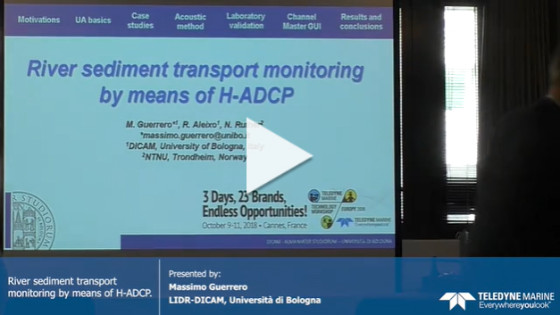
River Sediment Transport Monitoring by Means of H-ADCP
Monitoring stations in rivers and water courses are an important mean to obtain critical data about the different variables that play a role in the hydrodynamics and ecological processes. This is especially true during rough weather conditions when direct observations are not possible and even dangerous. A technique to determine the suspended sediment transport by means of fixed ADCPs at the side of a river channel (i.e., H-ADCP) is here presented. This technique relies on the Channel Master by Teledyne-RDI which continuously measures water velocity and echo intensity profiles along an horizontal alignment, these measurements are then transmitted to a remote server via GSM. In addition the proposed technique is based on an acoustic method to investigate poorly sorted sediment in the spectrum ranging from clay to fine sand. This combines the measurement of sound attenuation and backscatter to determine instrumental sensitivity to actual matter suspended in the horizontal alignment, thus relaxing the need of frequent calibrations to account for changes in the backscatter return not ascribable to a change in suspended sediment concentration, SSC. Last but not least a Matlab GUI was developed for the acoustic method implementation-validation and its coupling with discharge assessment using water velocity profiles from the Channel Master. The overall technique was applied in two very different case studies: i) the Devoll river in Albania that is a typical mountain stream with flow velocity and SSC larger than 5 m/s and 10 g/l during floods, respectively, in this case the monitoring serves hydropower industry; ii) the Secchia river where the observed peaks were close to 1.5 m/s and 2 g/l, this is the case of an embanked stream flowing in one of the most populous and heavily built areas of Italy where the monitoring station serves the prediction of sediments deposition and erosion close to existing infrastructures (e.g., bridge and levee). Presenter: Massimo Guerrero LIDR-DICAM, Università di Bologna at Teledyne Marine Technology Workshop Europe 2018
Do you have questions about this presentation?
Get in touch with Teledyne Marine, and they would be happy to answer any questions you have about pricing, suitability, availability, specs, etc.

