![ELCOVISION-10[1].jpg](https://cdn.geo-matching.com/wRWm7Gyp.jpg?w=300&h=300&crop=1&s=d9595e4eab382ce38f888d623cb550d7)
ELCOVISION ELTheo
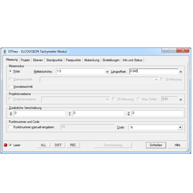
ELCOVISION 10 ElTheo is a "device driver" for total stations with serial or Bluetooth interface, which enables a CAD program to communicate directly with the total station. The main advantage is that every function of the CAD system becomes a measurement function. The total station can be used like a 3D Digitizer. A digital 3D drawing of the object is created on site. Visit our website to download a evaluation version of ELCOVISON ELTheo!

PMS Photo Mess Systeme AG
St. Margrethen, CH
Description
ELCOVISION 10 ElTheo is a "device driver" for total stations with serial or Bluetooth interface, which enables a CAD program to communicate directly with the total station. The main advantage is that every function of the CAD system becomes a measurement function. The total station can be an be used like a 3D Digitizer. A digital 3D drawing of the object is created online.
The integration of the measuring instrument into the CAD environment also offers the advantage that design and measurement are one. However, not only 3D measurement is supported, but also distances measured with a folding rule or the Leica DISTO can be incorporated without any additional effort.
ELCOVISION 10 ElTheo offers multiple methods to stationing a total station and supports multiple measurement modes like polar measurement, plane intersection and forward intersection.
ELCOVISION 10 ElTheo is seamlessly integrated into AutoCAD 2019-2022 and BricsCAD V19-V22 and offers multiple additional drawing functions especially suited for 3d reconstruction.
Do you have questions about this product?
- Questions about price, availability, and/or retailers
- Questions about technical specifications and usage
- Questions about suitability for your project or application
Specifications
-
Data management
-
Save standardization for drawings/maps
Spatial reference system
-
Geometry types
-
Points
Point, Multipoint, Symbol, Text
Lines
Line segment, Polyline, Multiline, Arc, B-spline, Others
Surfaces
Polygon, Circle, Multipolygon, Others
-
Other
-
License or freeware
License
Training
Y
Main users
Surveyors, Architects, Archaeologists, Craftsman
Main applications
3D Plans, Floor Plans, Documentation
Related products
ELCOVISION 10 Photogrammetry
Extensions
none
-
2D Editing
-
Select
By drawing attributes, Select by administrative attributes, Spatial selection, Multiple select, Others
Remove
Graphic transformations
-
2D Construction
-
Positioning by coördinates
Y
Positioning by snapping
Y
Positioning on virtual raster
Y
Positioning by Dimensions
Y
Positioning in relation to other element
Parallel, Extend, Collinear, Perpendicular, Particular angle, Others
-
Storage
-
Type of data storage
File, Database
Native storage format
DWG, DXF
Input formats
Dwg, Dxf, Jpg, Others
Export formats
Dwg, Dxf, Others
-
Visualisation
-
Types
Color, Pattern, Hatch, Gradient color
Change view
Zoomfactor, Target point, Twist angle
-
Data analysis
-
Clip
Y
Merge
Others
Measurement
Topology
Others
-
Interoperability
-
Web standards
None
Spatial database management systems
None
Messaging protocols
None
Publish standards
None
Extensions
none
-
General
-
Year of introduction
1998
Year of last update
2022
Supported operation system
Windows
Documents
Brochure
ELTheoV2_Englisch.pdf
Other documents
-
Broschüre ELTheoV2_Deutsch.pdf175.77 KB
-
ELTheoV2_English.pdf168.29 KB
Related products
