
Riegl and Z+F sensors now available in OxTS Georeferencer 2.7
OxTS Georeferencer is a software tool designed for LiDAR surveyors. With many automotive-grade sensors already integrated, version 2.7 sees the inclusion of survey-grade LiDAR sensors for the very first time!
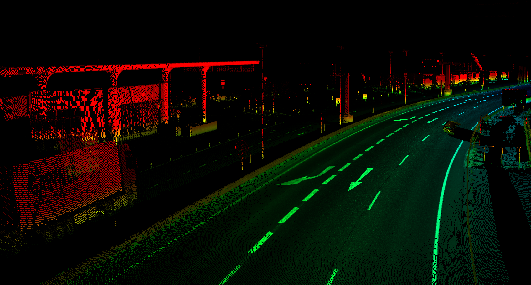
We’re delighted to announce that sensors from industry leaders Riegl and Z+F now exist within OxTS Georeferencer. This means that you can now use the boresight calibration tool to align the coordinate frames of your Riegl and Z+F sensors with your INS. You can then use OxTS Georeferencer to georeference the data.
Riegl and Z+F users – get the edge over your competition with OxTS Georeferencer 2.7.
Users of both 3rd party and OxTS GNSS/INS devices can now align the coordinate frames of their navigation device with that of their Riegl MiniVUX and Z+F Profiler LiDAR sensors. Accurate calibration will eliminate the error caused by sensor misalignment and therefore enhance the quality of your pointclouds.
The result? You, one step ahead of your competitors.
OxTS Georeferencer - one software suite, many possibilities
Whatever you’re using LiDAR for, OxTS Georeferencer has something for you.
The software includes out-of-the-box compatibility with a range of sensors from multiple LiDAR families and works seamlessly alongside other OxTS technology to enhance the quality, and improve the efficiency of your work.
Here are some of our favourite features…
+ Quickly and easily align the coordinate frames of your payload – eliminate blurring and double-vision from your pointclouds and win more business with the boresight calibration tool.
Compatible with any navigation device and LiDAR sensor combination, the boresight calibration tool will elimate the error caused by sensor misalignment and give you the edge over your competitors. The process is quick and simple, meaning you can begin creating more accurate pointclouds in minutes.
+ Spend more time surveying and increase revenue with batch processing – improve survey efficiency and increase productivity with the batch processing feature. Process multiple navigation (.CSV and .NCOM) and LiDAR (.LCOM and .PCAP) files simultaneously.
Conduct multiple surveys using the same vehicle(s) before processing the data at a more convenient time. This additional functionality allows you to spend more time out in the field collecting data and helps you to be more efficient with your time.
+ Use OxTS Georeferencer alongside any sensor combination with anyNAV – struggling to align the sensors on your existing payload? No need to worry. OxTS Georeferencer, with the anyNAV feature enabled, allows you to take advantage of OxTS’ boresight calibration tool and georeferencing software on your existing payload – whatever combination of sensors you’re using.
Read the OxTS Georeferencer datasheet to learn more - https://www.oxts.com/datasheet-oxts-georeferencer/
Do you have questions about this news item?
Get in touch with Oxford Technical Solutions - OxTS, and they would be happy to answer any questions you have about pricing, suitability, availability, specs, etc.


![YRBKMWXn[1].png](https://cdn.geo-matching.com/En53gY1o.png?w=320&s=7a38f8b5a386c40e410a744082db4a37)

