


Inertial Labs and E38 Company Announce Strategic Partnership for Advanced LiDAR Integration in E455 Drones
Inertial Labs, a leading innovator in the field of inertial sensor technology, and E38 Company, a prominent developer of cutting-edge drone solutions, are excited to announce a strategic partnership that will see the integration of Inertial Labs' RESEPI Payload LiDAR technology into E38's advanced E455 drone platform. This collaboration marks a significant milestone in utilizing unmanned aerial systems (UAS) for professional surveying, mapping, and inspection services.
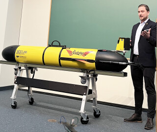
RESEPI (Remote Sensing Payload Instrument) is a sensor-fusion platform for accuracy-focused remote sensing applications. RESEPI utilizes a high-performance Inertial Labs INS (GPS-Aided Inertial Navigation System) and a high-accuracy single or dual-antenna GNSS receiver integrated with a Linux-based processing core and data-logging software. The RESEPI Payload LiDAR system will be seamlessly integrated with the E455 drone, enhancing its capabilities to capture high-resolution, 3D spatial data across various environments. This integration is set to revolutionize how industries such as construction, agriculture, and environmental monitoring conduct their operations, offering unprecedented detail and accuracy.
The E455 is an innovative fixed-wing vertical takeoff and landing (VTOL) UAS designed to operate on battery power with a maximum takeoff weight of up to 65 lbs. It features a removable payload bay with an open architecture at the center of gravity, ensuring maximum utility and flexibility for various mission requirements. The E455 can fly for over 2 hours or carry up to 15 lbs of payload, making it an ideal platform for extensive surveying and mapping missions with the integrated RESEPI Payload LiDAR system.
Jamie Marraccini, Inertial Labs CEO, expressed enthusiasm about the partnership, stating, "By combining our advanced RESEPI Payload LiDAR with E38's sophisticated E455 drone, we are setting a new standard for aerial surveying and mapping technology. This collaboration represents a leap forward in our mission to provide comprehensive, turnkey solutions that empower industries to achieve more."
Andrew Wilber, Business Development Specialist for Event 38 Unmanned Systems, Inc., added, "The E455's unique VTOL capabilities, extended flight duration, and versatile payload capacity, combined with Inertial Labs' leading RESEPI LiDAR technology, enhance our offering to the market. It provides our clients an unparalleled, accurate, efficient, and safe data collection tool. We're proud to partner with Inertial Labs and excited for the opportunities this partnership opens up."
Combining the E455 drone's robust flight capabilities with the high-precision LiDAR technology of the RESEPI payload will enable users to gather detailed topographic data in challenging terrains and under diverse conditions.
About Inertial Labs
Founded in 2001 and based in Northern Virginia, Inertial Labs is a trailblazer in developing innovative essential navigation solutions for our customers by providing state-of-the-art products and services so that they can achieve their ideas and aspirations. We plan to continue providing high-quality, cost-competitive, quick turnaround service while adding cutting-edge technology to our capabilities.
For further information and specifications on the Inertial Labs products, please call +1-703-880-4222, e-mail [email protected], or visit us on the Web: www.inertiallabs.com
About E38
Event 38 Unmanned Systems is recognized as a premier Unmanned Aircraft Systems (UAS) provider. Their customers leverage the drones for various applications, including Security, Surveying, and Environmental Conservation.
The company's hybrid fixed-wing VTOL aircraft boast extended endurance capabilities, capable of covering vast distances of dozens of miles or spanning hundreds of acres. Offering many payload options and customizable solutions, these aircraft are designed to collect thermal, multispectral, and high-resolution imagery with centimeter-level geotagging accuracy.
For further information, visit the Web: https://event38.com/
For more information:
Leo Liu
Director of Mapping Solutions
Email: [email protected]
Website: https://inertiallabs.com
Do you have questions about this news item?
Get in touch with Inertial Labs, Inc., and they would be happy to answer any questions you have about pricing, suitability, availability, specs, etc.


