
About Viametris
Since 2008, Viametris has been developing innovative mobile scanning technologies in response to the complex challenges posed by 3D scanning. The French company offers precise, added-value solutions to improve acquisition processes and data management for Lidar-based mapping, management of point clouds and integration of the subsequent data collection. Always in search of new technological approaches, Viametris has now become a key player in mapping, offering a full range of indoor and outdoor mobile mapping systems: portable indoor and outdoor 3D system (bMS3D), outdoor mobile vehicle scanner (vMS3D), continuous 3D indoor mobile scanner (iMS3D) and continuous 2D indoor scanner (iMS2D).
Viametris also offers a range of post-processing (PPiMMS) and automatic data recognition (MaGeLAAn) software, specially adapted for surveying, architecture and BIM projects. Viametris: at the heart of SLAM technology For over ten years, Viametris has been a pioneering company thanks to its capacity to innovate and evolve its algorithms while offering mobile robotic technologies. The company has developed a unique, hybrid approach which brings together IMU (Inertial Measurement Unit), GNSS and SLAM (Simultaneous Localisation and Mapping) to respond to all the constraints that might skew a trajectory.
• The IMU can independently calculate a trajectory, but over a short period.
• The satellite positioning has long-distance coherence, but the slightest obstacle (tunnels, urban canyons, trees, etc.) disturbs the signal. In the event of outage, the IMU filters the signals for a limited time, but the position deviation increases by time.
• The SLAM is autonomous, using keypoints in the environment. However, the deviation increases by distance. Viametris’s hybrid approach, which is unique on the market, offers an uninterrupted trajectory computation which is also more accurate, and it does so by making IMU, GNSS and SLAM work together. Regardless of technical or environmental constraints, this trio makes it possible to obtain a precise trajectographic measurement.
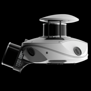
Featured products
Main office
-
Boulevard de la Communication / Koi centre d'Affaires
53950 Louverné
France -
+33 2 43 49 77 91
- https://www.viametris.com/


