VUX-160²³
„NFB“ (Nadir/Forward/Backward) Scanning UAV LiDAR Sensor
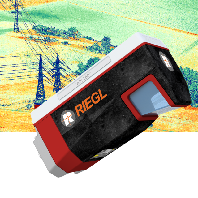
The new RIEGL VUX-160²³ is a lightweight and versatile airborne laser scanner offering a wide field of view of 100 degrees and an extremely high pulse repetition rate of up to 2.4 MHz. Thus, it is perfectly suited for high point density corridor mapping applications.

RIEGL | Innovation in 3D
Horn, AT
Description
The new RIEGL VUX-16023 is a lightweight and versatile airborne laser scanner offering a wide field of view of 100 degrees and an extremely high pulse repetition rate of up to 2.4 MHz. Thus, it is perfectly suited for high-point density corridor mapping applications.
The measuring beam of the RIEGL VUX-16023 is consecutively emitted in three different directions: it alternates from strict nadir to +10 degrees forward and -10 degrees backward. This allows data acquisition with unrivalled completeness in data capture, especially in challenging environments with vertical surfaces and narrow canyons.
The scanner provides an internal data storage capacity of 2 TByte and a removable CFast card and is equipped with interfaces to integrate an external INS/GNSS system. Additionally, interfaces for up to five optional external cameras are available.
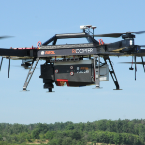
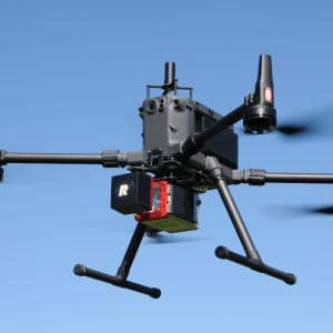
The sophisticated design of the RIEGL VUX-16023 allows smooth integration on UAS/UAV/RPAS, small manned aeroplanes (like gyrocopters), and helicopters. It is offered both as a stand-alone UAV LiDAR sensor and also in various fully-integrated UAV-based laser scanning system configurations with appropriate INS/GNSS systems to meet all the specific requirements of thcustomer'ss‘ applications perfectly and optional cameras. This allows the scanner to perfectly meet all the specific requirements of thcustomer'ssto meet all the specific requirements of thcustomer'ss‘ applications perfectly‘ applications.
Do you have questions about this product?
- Questions about price, availability, and/or retailers
- Questions about technical specifications and usage
- Questions about suitability for your project or application
Specifications
-
Application
-
Main applications
• Corridor Mapping: Power Line, Railway Track and Pipeline Inspection • Topography in Open-Cast Mining • Surveying of Urban Environments • Archeology and Cultural Heritage Documentation • Agriculture & Forestry
Distinguishable features
• laser pulse repetition rate up to 2.4 MHz • measurement rate up to 2,000,000 meas./sec • scan speed up to 400 lines/second • operating flight altitude up to 900 m / 2,950 ft • Field of View up to 100° • compact & lightweight (2.65 kg / 5.8 lbs) • Nadir/Forward/Backward Scanning for unrivaled completeness of scan data even on vertical structures and narrow canyons • cutting edge RIEGL technology providing: echo signal digitization, multiple target capability, online waveform processing, multiple-time-around processing • easily mountable to unmanned platforms (UAVs) and small manned aircraft • mechanical and electrical interface for INS/GNSS integration • interfaces for up to 5 external cameras • scan data storage on internal SSD Memory • removeable CFAST® memory card
-
Measurement Characteristics
-
Scanning method
rotating polygon mirror
Range accuracy [mm]
5
Scanning Speed [measurements p second]
2000000
multiple pulses in air
Y
Min. pulse frequency [Hz]
300000
Max. pulse frequency [Hz]
2400000
Max. field of view [degrees]
100
Max. number of recorded echoes per pulse
32
-
Physical Properties
-
Height [cm]
13.4
Length [cm]
28.2
Width [cm]
11.7
Weight [kg]
2.65
Water and dust proof
64
-
Laser Pulse Characteristics
-
Laser Class
1
Beam divergence [mrad]
0.4
Min. range of laser pulse [m]
5
Max. range of laser pulse [m]
900
-
Power Supply
-
Power consumption
60
Power requirements
18 - 34 V DC
-
Operation Characteristics
-
Camera included
-
Data and Software
-
Type of storage
SSD
Max. storage space [mb]
2000000
-
General
-
Year of introduction
2022
Documents
Brochure
datasheet_vux-160-23
Other documents
-
Infosheet ULS Overview.pdf2.63 MB
-
RiPROCESS Datasheet.pdf3.99 MB


