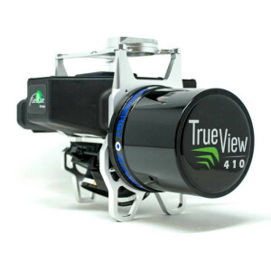
True View 635/640
Featuring RIEGL miniVUX-3UAV laser scanner, dual GeoCue Mapping Cameras and Applanix Position and Orientation System (POS) and includes post-processing software.
The True View 635/640 is a compact, survey-grade 3D Imaging Sensor (“3DIS”) designed for small Unmanned Aerial Systems (sUAS or drone). It comprises a survey-grade RIEGL laser scanner with dual photogrammetric cameras that have been carefully configured to provide a fused LIDAR/imagery field of view (FOV). The system includes full post-processing software that generates a ray-traced 3D colorized point cloud and geocoded images.
GeoCue Group Inc.
Madison, US
Description
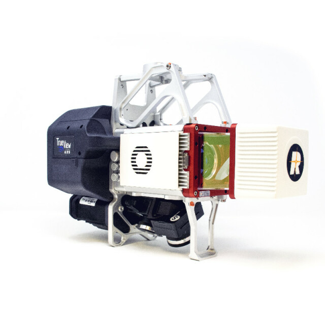
True View® 635/640
The True View® 635/640 is GeoCue’s second generation of integrated LIDAR/camera fusion platform designed from the ground up to generate high accuracy 3D colorized LIDAR point clouds using the RIEGL miniVUX-3UAV. Featuring dual GeoCue Mapping Cameras, a Riegl miniVUX-3UAV laser scanner and Applanix Position and Orientation System (POS), the result is a true 3D high accuracy imaging sensor (3DIS). With its wide 120° fused field of view, the True View 615/620 provides high accuracy 3D color mapping with excellent vegetation penetration and wire detection in a payload package of 3.2-3.6 kg.
The RIEGL miniVUX-3UAV laser scanner provides range of up to 120m with up to five returns per outgoing pulse. The miniVUX-3 is RIEGL's update of the miniVUX-2, with selectable pulse Repitition Rate to 200,000 pulses per second.
True View EVO is the software used to post-process your raw flight data. EVO will generate a 3D LIDAR point cloud in LAS format, colorize the point cloud, and geotag the images collected. It is based on GeoCue’s LIDAR point cloud exploitation software, LP360, and comes with all the same tools as LP360 Advanced. Tools such as accuracy assessment, automatic and manual ground classification, and contour/ surface exporting.
True View EVO gives mappers and surveyors the ability to deliver high quality analytic data with exacting accuracies. True View EVO lets users ingest data from a True View sensor and process to end products without the need to employ other software applications. This is a huge reduction in workflow complexity and a big-time saver.
True View 6XX Specifications
| Specification | True View 635 | True View 640 |
|---|---|---|
| LIDAR Scanner | RIEGL miniVUX-3UAV | - |
| LIDAR Range - usable | 100 m for targets with > 20% reflectivity | - |
| Cross-track Field of View -usable | 120° | - |
| LIDAR Returns | Up to 5 per outgoing pulse | - |
| Pulse Repetition Rate | 100,000 or 200,000 pulses/sec (selectable) | - |
| Accuracy | Better than 3 cm RMSE | Better than 2 cm RMSE |
| Precision | Better than 2.5 cm at 1 σ | Better than 2 cm at 1 σ |
| Dual Camera (Port, Starboard) | ±25° off-nadir, cross-track | - |
| Camera Sensor | Sony 1” CMOS IMX-183 1’’ mechanical shutter, hardware mid-exposure pulse, 20 MP, RGB | - |
| Camera Lens | 28 mm ƒ, 2.8 Max F Stop, fixed focus | - |
| Camera Cross-track FOV | 120°, total | - |
| Camera Trigger | Interval or Distance | - |
| Mass | 3.0 kg with battery | 3.5 kg with battery |
| Operating Time (per battery) | > 1 hr | - |
Specifications
-
Application
-
Training, maintanence and support
Training, 1st year maintenance included
Distinguishable features
Integrated dual cameras with FOV matched to LIDAR, full-post-processing software
Main applications
Survey grade UAV-based topographic survey
-
Measurement Characteristics
-
Min. pulse frequency [Hz]
100000
Max. pulse frequency [Hz]
200000
Max. field of view [degrees]
120
Scanning method
Rotating mirror
Range accuracy [mm]
15
Scanning Speed [measurements p second]
100
multiple pulses in air
N
Max. number of recorded echoes per pulse
5
Recording of intensity of return signal [bits]
16
-
Physical Properties
-
Height [cm]
24.5
Length [cm]
35.3
Width [cm]
170
Weight [kg]
3.5
Water and dust proof
Resistant
-
Laser Pulse Characteristics
-
Wavelength [nm]
900
Beam divergence [mrad]
0.5
Laser Class
Class 1
Min. range of laser pulse [m]
3
Max. range of laser pulse [m]
160
-
Power Supply
-
Power requirements
RRC-2054 batteries (Included)
Type of battery
Lithium Ion
Operation time on single battery [minutes]
60
Power consumption
35 W, Self-contained power
-
Positioning System
-
Number of GNSS positioning sensors
1
Type of GNSS positioning sensors
Applanix APX-15/Applanix APX-20
Type of INS or IMU
Applanix APX-15/APX-20
Typical positioning accuracy [cm]
2
Heading, Pitch and Role internally captured
Y
-
Operation Characteristics
-
Camera included
Yes
Mounting
Flat plate or Ronin dove tail
Requirements for compatible UAVs
Any drone capable of carrying 3.2 kg(615), 3.5 kg (620)
Camera specifications
Dual, 20 MP each, mechanical shutter, electronic mid-exposure pulse, fixed focus lens
Control and user interface
USB
-
Data and Software
-
Type of storage
SSD
Included software
POSPac, True View EVO
Max. storage space [mb]
128000
-
General
-
Year of last update
2021
Year of introduction
2020
Related products


