
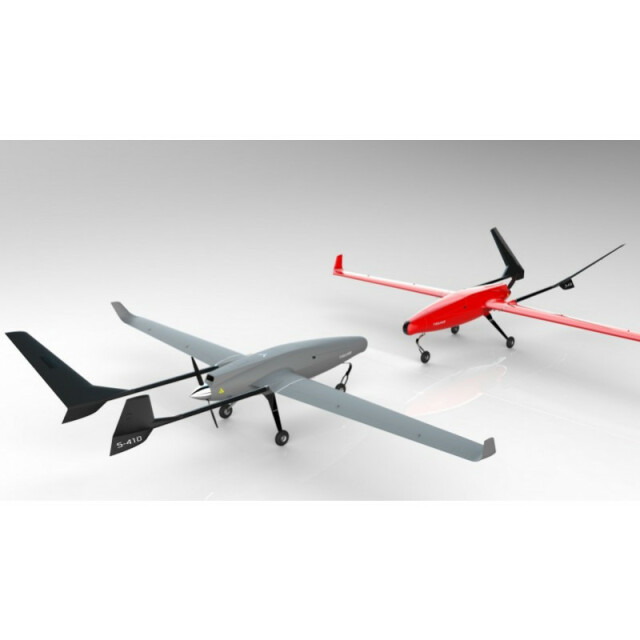
Description
Tiguar is a fully integrated, state-of-the-art unmanned system that fits under the U.S. Federal Aviation Administration 55 lbs. regulation and meets Polish Civil Aviation Authority requirements rgarding UAVs. It is a high endurance, safe and modular systems that can be deployed for aerial inspection, monitoring and surveillance missions
Specifications
-
Environment
-
Min. operation temperature [°C]
-20
Max. operation temperature [°C]
+40
Max. wind speed [m/sec]
0
Max. humidity [%]
0
-
Imaging/scanning devices
-
Onboard imaging/scanning devices
RGB Camera, Lidar, Additional sensors, Gimbal, NIR Camera, SWIR Camera
Type of Camera
FPV, 30x Zoom
Type of Lidar
Yellowscan
Additional Sensors and additional information
Thermal, Infrated scanners,
Build-in Stablilsation
Y
Exchangeable
Y
Sensor tilting to allow oblique views
Y
-
Platform
-
Platform
Aircraft
Brand
Tiguar
Max. payload [kg]
25
Max. stay in the air [min]
1440
Max. speed [km/h]
144
Max. height above sea level [m]
0
Propulsion
electric-gasoline
-
Accessories
-
Transportation accessories
-
Included batteries and charger
-
More included products and spare parts
-
-
Operation Characteristics and Safety
-
Min. ø of launch/landing site [m]
100
Launching method
automatic takeoff
Automatic launch and landing
Y
Training provided
Y
Collision avoidance systems (CAS)
Y
Autonomous emergency landing
Y
-
Dimensions
-
ø / wingspan [cm]
401
Height [cm]
232
Weight [kg]
0
Weight of battery [kg]
0
Weight of filled fuel tank [kg]
0
Number of rotors
1
Transport on human back
N
-
Base Station
-
Ground computer included
N
Type of Ground computer
-
Sensor control
Y
Real time image and video download link
Y
-
Navigation Sensors
-
Type of GNSS receiver and captured signals
-
Type of IMU
-
Other sensors and additional information
-
Correction services [PPK, RTK]
-
-
General
-
Year of last update
2016
Typical applications
S&R, Geomodeling, Monitoring
-
Included software and automatically generated
-
Type of software included
Block adjustment, Camera self-calibration, Flight planning, Photogrammetric software, Point cloud processing software
Flight planning software
-
Photogrammetric software
-
Point cloud processing software
-
Automatically Generated Products
3D City Models, Point Clouds, 3D Landscape Models, DEMs, DTMs, Orthomosaics, NDVI maps
Additional information on software or automatically generated products
-


