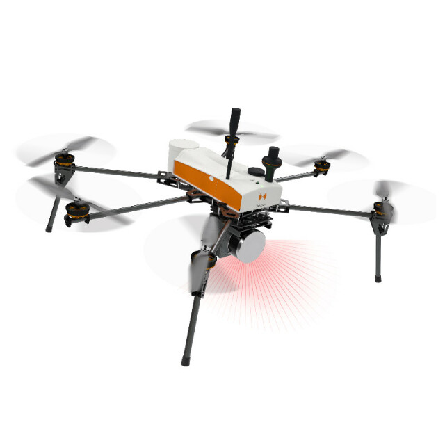
Description
The SuperFox6 drone surveyor has 43 minutes autonomy. Thus, it triples the capabilities of its predecessor: the Fox6. A single flight of SuperFox6 is equivalent to 3 flights of Fox6. In addition, this aerial multi-rotor drone is fully automated. It can carry out a wide variety of topographic surveys up to 150 hectares (370 acres). The SuperFox6 drone surveyor is designed for large photogrammetric missions. It allows the orthophotos, point clouds and DTM production. It is also compatible with the new Hélicéo LiDAR System.
Hélicéo drones are known for their exceptional wind resistance. The SuperFox6 further pushes the limits of the exercise with 55 Km / h of wind resistance. With a new engine power generation offering a 20% increase in wind resistance, it is even more powerful. It allows you to fly in extreme conditions for more mission opportunities.
In order to save you even more time during your missions, Hélicéo designed the Trimble RTK Drone Box and the HASK software. They allow you to break free from the time-consuming stage of target positioning in the field. The HASK and the DroneBox allow you to achieve a 3 cm accuracy in X and Y and 5 cm in Z.
Specifications
-
Environment
-
Min. operation temperature [°C]
-10
Max. operation temperature [°C]
45
-
Imaging/scanning devices
-
Onboard imaging/scanning devices
RGB Camera, Lidar, Additional sensors, Gimbal
-
Platform
-
Platform
Copter
Brand
Hélicéo
Max. payload [kg]
4
Max. stay in the air [min]
43
Max. speed [km/h]
50
Max. height above sea level [m]
150
-
Accessories
-
Transportation accessories
Rolling FligtCase
Included batteries and charger
Yes
-
Operation Characteristics and Safety
-
Min. ø of launch/landing site [m]
5
Launching method
VTOL
Automatic launch and landing
Y
Training provided
Y
Collision avoidance systems (CAS)
N
Autonomous emergency landing
Y
-
Dimensions
-
Height [cm]
53
Weight [kg]
6
Weight of battery [kg]
0.3
Weight of filled fuel tank [kg]
0
Number of rotors
6
Transport on human back
N
-
Base Station
-
Ground computer included
Y
Type of Ground computer
Computer or Tablet
Sensor control
Y
Real time image and video download link
Y
-
Navigation Sensors
-
Type of GNSS receiver and captured signals
TRIMBLE RTK L1/L2
Other sensors and additional information
Alpha 6000 24 mpxAlpha 7R 36 mpxParrot SequoiaFlir Vue ProR 336Flir Vue ProR 640
Correction services [PPK, RTK]
PPK & RTK
-
General
-
Year of last update
2018
Typical applications
photogrammetry, 3D mapping, surveying, LiDAR
-
Included software and automatically generated
-
Photogrammetric software
Pix4D
Point cloud processing software
Trimble Real Works
Type of software included
Flight planning, Photogrammetric software, Point cloud processing software
Automatically Generated Products
3D City Models, Point Clouds, 3D Landscape Models, DEMs, DTMs, Orthomosaics


