
Description
SkyWalker X62 can load various payloads: DSLR camera, airborne RTK/PPK Receiver, 2-Lens camera, Integrated 5-lens camera system, 3D Laser Scanner, Digital wireless video transmitter, Hyperspectral Imager, Infrared Thermal Imager, etc. We are dedicated to provide various products (Orthomosaic, DOM, DSM, DEM, TDOM, DLG, contour lines 3D model, etc.) for users.
Specifications
-
Environment
-
Min. operation temperature [°C]
-10
Max. operation temperature [°C]
45
Max. wind speed [m/sec]
10
Max. humidity [%]
90
-
Imaging/scanning devices
-
Onboard imaging/scanning devices
RGB Camera, Lidar, Additional sensors, Gimbal, NIR Camera, SWIR Camera
Type of Lidar
South SZT-V1 recommended
Additional Sensors and additional information
Large variety of payloads available: Airborn LiDAR, Multi-Lens Camera systems, Infrared Thermal Imager, Hyperspectral Imaging Camera, Digital Wireless Video Transmitter, Ultrahigh Resolution (100MP) Camera. Easy to install due to guide-rail typed connection.
Build-in Stablilsation
Y
Exchangeable
Y
Sensor tilting to allow oblique views
Y
-
Platform
-
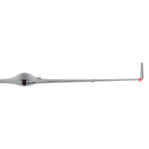
Platform
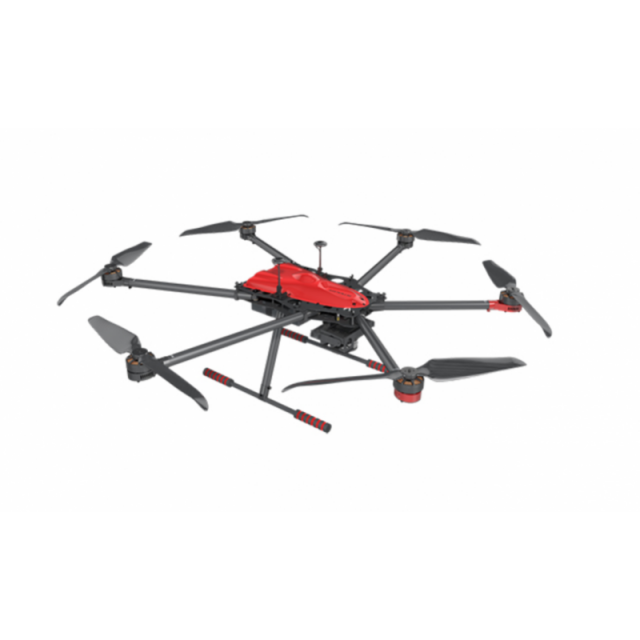
Copter
Brand
South
Max. stay in the air [min]
60
Max. speed [km/h]
36
Max. height above sea level [m]
3500
Propulsion
Electric pusher propeller, 6 brushless motors
-
Operation Characteristics and Safety
-
Launching method
Vertical Take-off & Landing System (VTOL)
Automatic launch and landing
Y
Autonomous emergency landing
Y
-
Dimensions
-
ø / wingspan [cm]
120
Height [cm]
40
Weight [kg]
4
Number of rotors
6
Transport on human back
Y
-
Base Station
-
Sensor control
Y
Real time image and video download link
Y
-
Navigation Sensors
-
Type of GNSS receiver and captured signals
Attachable module SkyLines-mini, L1/L2 (GLONASS, Beidou, Galileo)
Type of IMU
2 Gyroscopes, 6 Accelerometers
Other sensors and additional information
Magnetometer (magnetic heading), Barometer (altitude), 2s GPS Receiver (Spatial positioning and Waypoint navigation)
Correction services [PPK, RTK]
PPK
-
General
-
Typical applications
Agriculture, 3D Cartography, Rescue Operations
-
Included software and automatically generated
-
Automatically Generated Products
3D City Models, Point Clouds, 3D Landscape Models, DEMs, DTMs, Orthomosaics, NDVI maps
Type of software included


