Geoscan Lite
Light the way of your survey
Geoscan Lite is fixed-wing drone (automatic aerial survey system), designed to boost the quality and efficiency of mapping. With the ability to install various cameras, Geoscan Lite helps you handle any project and simplify and optimize workflows.
GEOSCAN GROUP
St. Petersburg, RU
Description
Geoscan Lite is fixed-wing drone (automatic aerial survey system), designed to boost the quality and efficiency of mapping. With the ability to install various cameras, Geoscan Lite helps you handle any project and simplify and optimize workflows.With the ability to install various cameras, Geoscan Lite helps you handle any project and simplify and optimize workflows.
With its flight time up to 80 minutes it offers up to 500 ha with GSD up to 3 cm/px. And onboard receiver GNSS Topcon (PPK) helps you achieve absolute accuracy of down to 3 cm, without GCPs.
Automated aerial photography process
Simply select the area and set parameters needed to start an aerial survey. The flight plan will be loaded to autopilot, and you need only to confirm the launch. Geoscan Lite will perform the mission with the specified altitude and images’ overlap.
Specifications
-
Environment
-
Min. operation temperature [°C]
-20
Max. operation temperature [°C]
40
Max. wind speed [m/sec]
13
-
Imaging/scanning devices
-
Onboard imaging/scanning devices
RGB Camera, NIR Camera
Type of Camera
Modernized Sony A6000
Exchangeable
Y
-
Platform
-
Brand
Geoscan
Max. stay in the air [min]
80
Max. speed [km/h]
130
Max. height above sea level [m]
4000
Platform
Aircraft
Max. payload [kg]
0.8
Propulsion
single pusher propeller, brushless electric motor
-
Accessories
-
Transportation accessories
Transport case with wheels and troley handle
Included batteries and charger
2 batteries with charging station
More included products and spare parts
spare parts, propellers. rubbers for catapult
-
Operation Characteristics and Safety
-
Launching method
catapult, automated mode
Automatic launch and landing
Y
Min. ø of launch/landing site [m]
60
Training provided
N
Autonomous emergency landing
Y
Collision avoidance systems (CAS)
N
-
Dimensions
-
ø / wingspan [cm]
138
Weight [kg]
3.1
Transport on human back
Y
-
Base Station
-
Ground computer included
N
Type of Ground computer
Windows-based laptop
Real time image and video download link
N
-
Navigation Sensors
-
Type of GNSS receiver and captured signals
GPS+GLONASS
Correction services [PPK, RTK]
PPK (additional)
-
General
-
Year of last update
2020
Typical applications
Urban development; Construction;
Product Name
Geoscan Lite
-
Included software and automatically generated
-
Type of software included
Flight planning
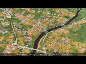
Automatically Generated Products
3D City Models, Point Clouds, 3D Landscape Models, DEMs, DTMs, Orthomosaics, NDVI maps
Flight planning software
Geoscan Planner
Photogrammetric software
Agisoft Metashape (to be purchased additionally)
Point cloud processing software
Agisoft Metashape (to be purchased additionally)
Additional information on software or automatically generated products
Sputnik GIS (free)
Videos


