Geoscan 401
Geoscan 401 Geodesy
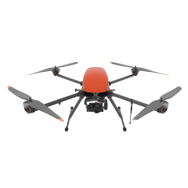
Aerial photography system with vertical take-off and landing with Flight time up to 1 hour. Can work in a confined space and accurately bend the relief. With Geoscan 401 Geodesy, you can survey high-rise structures (pipes and utility poles), objects with pronounced relief and significant altitude differences (quarries) or vertical surfaces (facades). Due to the onboard geodetic GNSS receiver, the obtained images allow the creation of the precise georeferenced orthophotos and 3D models.
GEOSCAN GROUP
St. Petersburg, RU
Description
Overview
Aerial photography system with vertical take-off and landing. Complex takes-off from a site with a diameter of 5 m, can work in a confined space and accurately bend the relief. With Geoscan 401 Geodesy, you can survey high-rise structures (pipes and utility poles), objects with pronounced relief and significant altitude differences (quarries) or vertical surfaces (facades). Due to the onboard geodetic GNSS receiver, the obtained images allow the creation of the precise georeferenced orthophotos and 3D models.
Survey area per one flight: at a scale of: 2 cm GSD- 0,95 km2; 3 cm GSD - 1,4 km2; 5 cm GSD - 2,1 km2
Geoscan 401 models:
- Geoscan 401 Lidar
- Geoscan 401 Geophysics
- Geoscan 401 Tethered
Geoscan 401 equipment
Geoscan 401 comes in two protective containers IP67, one for charging station, and another one is for ground control station and the UAV.
Basic package consist of:
- Unmanned aerial vehicle (UAV) Geoscan 401
- Battery with a protection system - 1 pc.
- Upgraded Sony DSC-RX1RII digital camera (42.4 MPix, 35 mm lens, full-size matrix, central shutter)
- Triple-system (GPS/GLONASS/BeiDou) Topcon GNSS receiver with dual band (L1/L2) antenna
- spare parts and accessories kit
- Flight management(or ground control station) software : Geoscan Planner
- Radio link modem for connection with UAV
- Charging station in transport container (IP67, sizes 50x40x19 cm, weight without batteries: 7.5 kg)
- Transport case (IP67, size: 80x52x31 cm, gr.weight: 16 kg)
- User manual
- UAV operator training course
Extra equipment
- Additional quadcopter Geoscan 401 (quadcopter, electronics, data link control/telemetry, protective IP67 container, spare parts)
Software to consider
- Metashape Professional
- GIS Sputnik
- GIS Sputnik Agro
- MAGNET Office Tools Adv. Post processing
Operator Training
- Introduction to Geoscan UAV & workflow
- Flight planning & management with Geoscan Planner
- Practical work in the field
Specifications
-
Environment
-
Min. operation temperature [°C]
-35
Max. operation temperature [°C]
50
Max. wind speed [m/sec]
12
Max. humidity [%]
95
-
Imaging/scanning devices
-
Onboard imaging/scanning devices
RGB Camera, Additional sensors
Type of Camera
Sony RX1 / A6100 / A7
Additional Sensors and additional information
Gyro-stabilized platform with FullHD / Thermal cam
Build-in Stablilsation
Y
Exchangeable
Y
Sensor tilting to allow oblique views
Y
-
Platform
-
Platform
Copter
Brand
GEOSCAN
Max. payload [kg]
2
Max. stay in the air [min]
60
Max. speed [km/h]
50
Max. height above sea level [m]
500
Propulsion
Electric
-
Accessories
-
Transportation accessories
Transport case with wheels and troley handle
Included batteries and charger
1 batteries with charging station
More included products and spare parts
spare parts
-
Operation Characteristics and Safety
-
Min. ø of launch/landing site [m]
5
Launching method
From ground (vertical take-off)
Automatic launch and landing
Y
Training provided
Y
Collision avoidance systems (CAS)
N
Autonomous emergency landing
Y
-
Dimensions
-
ø / wingspan [cm]
150
Height [cm]
56
Weight [kg]
3.4
Weight of battery [kg]
2.9
Weight of filled fuel tank [kg]
0
Number of rotors
4
Transport on human back
N
-
Base Station
-
Ground computer included
N
Type of Ground computer
Laptop
Sensor control
Y
Real time image and video download link
N
-
Navigation Sensors
-
Type of GNSS receiver and captured signals
GPS+GLONASS
Correction services [PPK, RTK]
PPK
-
General
-
Year of last update
2020
Typical applications
Surveying, GIS, Mining, Consruction, Inspection
Product Name
Geoscan 401
-
Included software and automatically generated
-
Type of software included
Block adjustment, Camera self-calibration, Flight planning, Photogrammetric software, Point cloud processing software
Flight planning software
GeoScan Planner
Photogrammetric software
Agisoft Metashape Pro
Point cloud processing software
Agisoft Metashape Pro
Automatically Generated Products
3D City Models, 3D Landscape Models, DEMs, Orthomosaics
Videos


