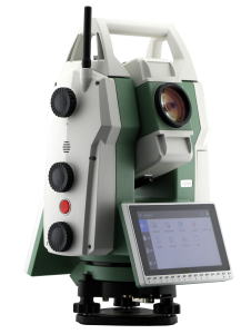
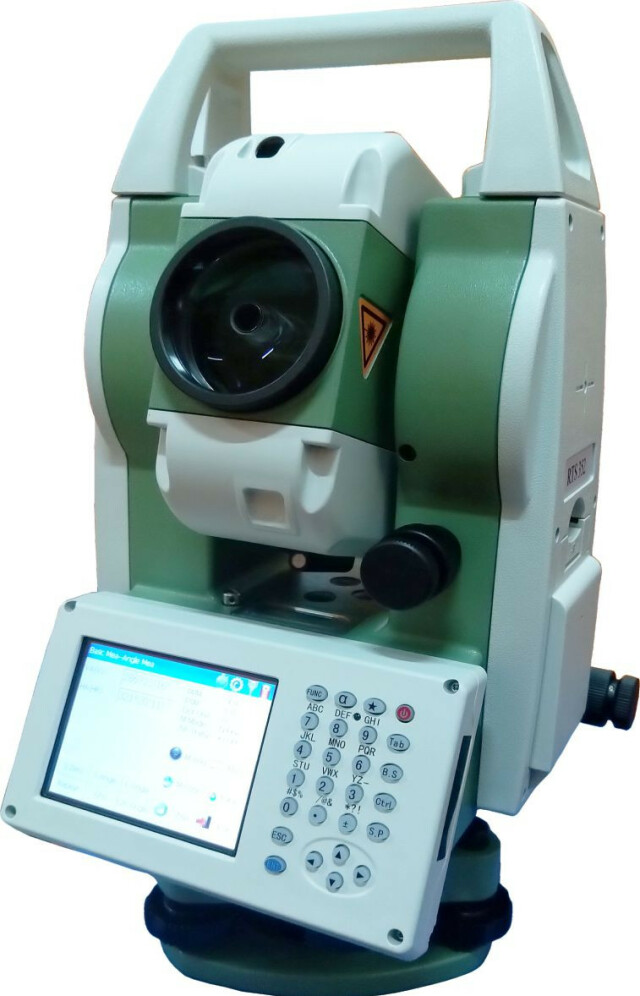
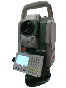
RTS350 Manual Total Station
The FOIF RTS350 series total station sets a new standard for advanced surveying and geospatial measurement technology. Meticulously engineered to cater to the diverse needs of surveying professionals, construction experts, and engineers, the RTS350 series combines cutting-edge innovation with user-friendly design to redefine efficiency and accuracy in the field.

FOIF
Suzhou, CN
Description
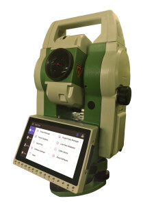
Designed with both form and function in mind, the FOIF RTS350 total station showcases a sleek and ergonomic build that ensures comfort during prolonged surveying sessions, even in challenging outdoor environments. This series is characterized by its exceptional precision, making it an indispensable tool for a wide array of applications, from land surveying and topographic mapping to architectural layout and infrastructure development.
Key features that define the FOIF RTS350 series include:
-
Unparalleled Accuracy: The total station offers industry-leading angle and distance measurement accuracy, enabling users to achieve precision down to sub-millimeter levels. This level of exactness is crucial for tasks demanding precise positioning and alignment.
-
Extended Range Capabilities: With impressive distance measurement ranges, including reflectorless measurements, the RTS350 series facilitates the efficient surveying of large areas and hard-to-reach points.
-
Advanced EDM Technology: Equipped with advanced Electronic Distance Measurement (EDM) technology, the total station delivers rapid and reliable distance measurements, even in challenging atmospheric conditions.
-
Intuitive Interface: The user-friendly interface and intuitive controls of the RTS350 series streamline surveying operations, allowing both seasoned professionals and newcomers to operate the instrument seamlessly.
-
Integrated Software Suite: The total station comes equipped with robust integrated software, facilitating data collection, processing, and analysis. This software accelerates project timelines by enabling users to swiftly generate accurate maps, plans, and reports.
-
Seamless Wireless Connectivity: Built-in wireless communication capabilities allow for effortless data transfer between the total station and external devices such as data collectors or computers.
-
Extended Battery Life: The RTS350 series is engineered to provide extended battery life, minimizing downtime caused by frequent battery changes and ensuring uninterrupted fieldwork.
-
Durable Construction: Built to withstand the rigors of outdoor usage, the total station's robust construction is designed to resist dust, water, and rough handling.
-
Versatile Surveying Modes: The FOIF RTS350 total station offers a range of surveying modes, including angle measurement, distance measurement, stakeout, and coordinate calculations, catering to a diverse range of project requirements.
Do you have questions about this product?
- Questions about price, availability, and/or retailers
- Questions about technical specifications and usage
- Questions about suitability for your project or application
Specifications
-
General
-
Area of Application
Construction, land management, geodesy, heritage protection, etc.
Depth [m]
0.22
Height [m]
0.36
Weight [kg]
6.5
Width [m]
0.185
Year of introduction
2013
Year of last update
2019
Display Panel
3.5" colour TFT LCD (320 x 240 dots) touch screen
-
User Interface
-
No. keys
26
Color display
Y
No. faces
2
Note recording capability
Y
On-board survey software
FOIF BaseMeasure, FOIF Surpad
Operating System
wince 7.0
Resolution [px rows x columns]
320*240
Screen type
TFT LCD
Screen size: length of diagonal ["]
3.5
Touchscreen
Y
-
Distance Measurement with Prism
-
Maximum range with 1 mini prism [m]
800
Maximum range with combined prisms [m]
5000
Maximum range with 1 standard prism [m]
5000
No. prisms for maximum range
3
Standard deviation: variable part [ppm}
2
Standard deviation: constant part [mm]
2
Prism EDM Range [m]
5000
Prism EDM Accuracy [mm]
2mm+2ppm
Measuring Time [s]
1
-
Integrated camera
-
Integrated camera available [Y/N]
N
-
Data Storage & Connectivity
-
Bluetooth {Y/N}
Y
Compact Flash [Y/N]
Y
Internal memory [GB]
4
Radio [Y/N]
N
RS-232 /422 Serial [Y/N]
Y
SD Card [Y/N]
N
USB [Y/N]
Y
WiFi {Y/N}
N
-
Miscellaneous
-
Guiding light
Y
Integration with GNSS receiver possible [Y/N]
N
Laser plummet
Standard
-
Automatic Tracking and Locking
-
Maximum Range [m]
No
Tracking and recovery of moving prism
N
-
Integrated Laser Scanning
-
Integrated laser scanning available [Y/N]
N
-
Operation
-
IP dust/water protection class [IPxx]
IP54
Maximum working temperature [degC]
50
Minimum working temperature [degC]
-20
-
Distance Measurement without Prism
-
Maximum range on Kodak white [m]
1000
Maximum range on Kodak gray [m]
1000
Minimum size of spot at maximum range [mm2]
31400
Minimum size of spot at 100m [mm2]
314
Standard deviation: constant part [mm]
3
Standard deviation: variable part [ppm]
2
Non-Prism Range [m]
1000
Non-Prism Accuracy [mm]
3mm+2ppm
-
Power Supply
-
Batteries hot-swappable
Y
Battery
lithium
Capacity
3400mAh
Max. operation time on one battery [hr]
8
-
Support
-
Reach of global support network
Yes
Standard warranty [years]
1
-
Angle Measurement
-
Division [arcsec]
2
Standard deviations of other versions in serie
2
Standard deviation [arcsec]
2
Compensation
Dual axis
IACS
No
Vertical Coverage
360°(dms/d)/400gon/6400mil
Horizontal Rotation
360°(dms/d)/400gon/6400mil
Guide Light
Yes
-
More information
-
Distinguishable features
Windows CE 7.0, trigger key, endless drives, on-board FieldGenius
-
Hardware
-
Laser Plummet
Yes
Auto Leveling
No
LED Indicators
No
Documents
Brochure
RTS350 brochure_En.pdf
5.76 MB

