

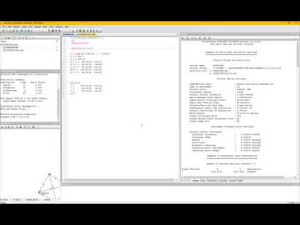
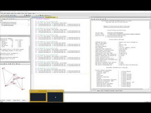
STAR*NET
MicroSurvey STAR*NET is an easy-to-use, highly adaptable least squares adjustment package for Surveying professionals.
Recognized worldwide as the best least squares adjustment software on the market, STAR*NET sets the standard as the easiest, most widely used and respected Least Squares software with the most understandable results. Let STAR*NET help you improve both the precision of your work and your confidence.

MicroSurvey Software Inc.
West Kelowna, CA
Description
Do you have questions about this product?
- Questions about price, availability, and/or retailers
- Questions about technical specifications and usage
- Questions about suitability for your project or application
Specifications
-
Laser scanning
-
Laser scan data collection
N
Compute unregistered point cloud
N
Point cloud registration to targets in cloud
N
Cloud to cloud registration
N
-
Photogrammetric data processing
-
Photo planning
N
Processing in cloud / on-premise
N
Airborne photography
N
Handheld terrestrial photography
N
Can more than one camera be used?
N
Camera calibration computed for all cameras used
N
Accepts input camera calibration data
N
Data from more than one camera supported
N
Accepts GNSS RTK photo exposure positions
N
Supports registration to ground control
N
-
GNSS data and processing
-
GNSS static / RTK data collection
N
GNSS setting out
N
Input data formats supported
Supports GNSS Vector import from all major manufacturers and software providers.
Static baseline post-processing
N
Output data for least squares adjustment with data from other sources
Y
Base and rover RTK
Y
Post processed kinematic
Y
Network RTK
Y
-
GNSS + dead reckoning data (mobile mapping)
-
IMU data used trajectory computation
N
SLAM data used in trajectory computation
N
Wheel odometer data used in trajectory computation
N
SfM (photogrammetry) used in trajectory computation
N
Adjust trajectory to fit overlapping point cloud data
N
Adjust trajectory to fit ground control points
N
Adjust point clouds (not trajectory) to fit ground control points
N
Trajectory provided with precision data
N
-
Levelling and Orientation
-
Import of instrument data
Supports raw Level observation import from all major manufacturers and software providers.
Rise and fall level book format output
N
Height of collimation level book format output
N
Unadjusted levels, adjustment and adjusted level shown
Y
Output data for least squares adjustment with data from other sources
Y
-
Total Station (TS) data processing
-
Traverse computation
Y
Output data for least squares adjustment with data from other sources
Y
Compute 3D radial observations
N
TS setting out
N
Feature attribute coding
N
Feature geometry coding
N
Data input formats supported
Supports raw Total Station observation import from all major manufacturers and software providers.
Data output formats supported
CSV, TXT, DXF, LandXML
-
CAD functions
-
CAD functions for Internal measured building surveys
N
CAD functions for open drainage modelling
N
CAD functions for Rail applications
N
CAD functions for Road applications
N
CAD functions for Pipeline applications
N
CAD functions for Overhead Power Line applications
N
CAD functions for Site development applications
N
CAD functions for Industrial plant applications
N
Output formats supported
CSV, TXT, KML, DXF, LandXML
-
General
-
Software version
10.0
Mobile (real time connected to instrument)
N
Laptop / Office computer (post processing)
Y
-
Integrated environment for
-
GNSS data
Y
GNSS + dead reckoning data (Mobile Mapping)
N
TPS data
Y
Point cloud data
N
Level data
Y
Integrated least squares computation of control
Y
Transformation between map projections
Y
Compute grid DTM
N
Compute TIN
N
Computation of sections through surfaces
N
Volume computation from sections
N
Volume computation by substracting surfaces
N
-
More information
-
Distinguishable features
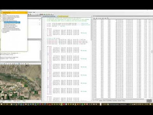
Easy to understand and modify input files. Support for all major file formats used in the industry.
Documents
Brochure
migrationyhxurk.pdf
5.56 MB
Other documents
-
Features and Benefits210.15 KB


