

eCognition Suite
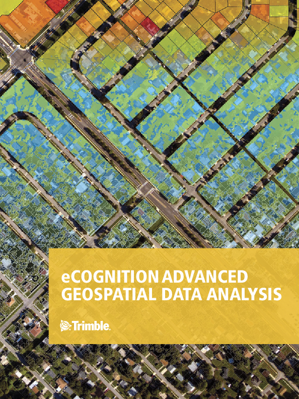
Trimble eCognition Suite is an advanced image analysis software available for geospatial applications. It is designed to improve, accelerate, and automate the interpretation of a variety of geospatial data and enables users to design feature extraction or change detection solutions to transform geospatial data into geo-information.

Trimble, Inc.
Westminster, US
Description
Trimble eCognition Suite is an advanced image analysis software available for geospatial applications. It is designed to improve, accelerate, and automate the interpretation of a variety of geospatial data and enables users to design feature extraction or change detection solutions to transform geospatial data into geo-information.
Do you have questions about this product?
- Questions about price, availability, and/or retailers
- Questions about technical specifications and usage
- Questions about suitability for your project or application
Specifications
-
Application
-
Main users
data providers (Woolpert; Blom; 3001; Photoscience etc.) Government Agencies (USDA; USFS; Ordnance Survey etc) research (NASA; JPL; Universities worldwide)
Main applications
forestry; urban planning; water management; environmental monitoring; Security&Defense
Distinguishable features
object-based image analysis leveraging context; scale; shape; colour and texture; works on raster; vector and point-clouds; client-server architecture optimized for large-scale production.
-
General
-
Year of introduction
2000
Year of last update
2018
Supported hardware
Intel x86_64 hardware platforms (64 bit)
User definable operations and extensions
Cognition Network Language & SDK
Other input data supported
GIS vectors (SHP & FileGDB), Point Clouds (LAS)
-
Object-based classification
-
Line extraction
skeletons; object resizing / surface tension
Region growing segmentation
Y
Multiresolution image segmentation
Y
Multiscale approach
Y
Generalisation
squaring of buildings; smoothing of contours; removing of clutter
-
Editing
-
Manual removal and addition of points; lines; polygons
Y
Addition of text and symbols
Y
Overlay with map data
Y
-
Classification in general
-
Ancillary data integration
Y
Sub-pixel classification
N
Training sample selection
Y
Accuracy assessment
Y
-
Radiometric and image processing
-
Radiometric corrections
normalisation adjustment; flexible channel arithmetics
Spatial convolutions
extensive pixel filtering algorithms
Image transforms
Y
Morphological operations
binary; grayscale; opening; closing; skeletonising; user definable structural elements
Filtering of radar imagery
Y
-
Pixel-based classification
-
Unsupervised classification
Y
Supervised classification
Y
Vegetation index
Y
Principal component analysis
N
-
Geometric processing
-
Correction models
N
Transformations
N
Cartographic projections
N
Ortho-image generation using DEM
N
Resampling
Y
Geometric accuracy assessment
N
Documents
Brochure
migrationv8e06a.pdf
1.7 MB
Related products


