VRMesh Feature Highlights
0
views
Join 40,000+ geospatial professionals and get technology news delivered straight to your inbox every week. Subscribe today.
VitualGrid
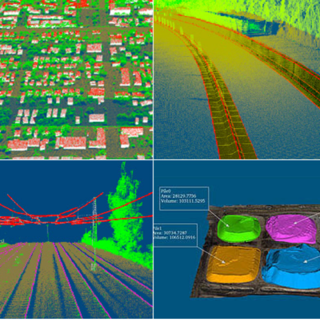
VRMesh is a point cloud processing software covering classification, feature extraction, construction modeling, point cloud meshing, and inspection. It is used for land surveying, infrastructure, construction, mining, etc.
VRMesh is an advanced 3D point cloud and mesh processing software tool. Our innovative technologies are aimed to provide powerful and easy solutions for engineering industries. The entire family of VRMesh consists of three packages targeted to different customers.
VRMesh Studio
A comprehensive solution covering automatic point cloud classification, feature extraction, accurate point cloud meshing, and advanced construction module. It includes all features in VRMesh.
VRMesh Survey
A next-generation solution for automatic point cloud classification and feature extraction. It enables you to easily classify vegetation, building roofs, and ground points in LiDAR data or from images. It can automatically detect building footprints, powerlines, poles, tree crowns, curbs and railway tracks in point clouds. It is also able to adjust airborne/mobile LiDAR strips with high accuracy.
VRMesh Reverse
A complete reverse engineering workflow for users to wrap point cloud data into accurate triangle meshes as well as NURBS surfaces. It delivers best-in-class point cloud processing and various mesh repair/editing tools. It also provides you automatic registration, inspection, volume calculation, and deviation measurement tools.
RAM [GB]
16
HD [GB]
500
Use of GPU
Y
Processor
["64-bit"]
Stereo Display
N
Stand-alone
Yes
Support
Training
Y
Typical applications
land surveying, infrastructure, construction, mining, utilities, etc.
Distinguishing features
point cloud classification, feature extraction, construction modeling, point cloud meshing, mesh editing, registration and measurement
Input formats
e57, las, laz, zlas, ptx, pts, xyz, rcp/rcs, dxf, shp, stl, obj, ply, fls, zfs, rdbx, 3ds, wrl, vtk, csv
Output formats
las, laz, zlas, pts, xyz, rcp/rcs, dxf, fbx, shp, igs, stl, obj, grid, wrl, ply, vtk, csv, x3d, pdf
Geo-referencing
N
Automatic Target Detection
Y
Stitching multiple scans
Y
Image matching facilities
N
Frequency domain decoding for data reduction
N
Removal of individual outliers
Y
Removal of vegetation
Y
Removal of buildings
Y
Bare ground DEM generation
Y
3D Coordinates extraction
Y
Length and Height
Y
Angle
Y
Distance
Y
Area
Y
Volume
Y
CAD software
AutoCAD, MicroStation, etc.
Assigning colour from imagery to points
N
Image overlay on TIN
N
Year of initial introduction
2004
Year of last update
2019
Modules
VRMesh is a standalone software including the following modules: Point Cloud Classification, Feature Extraction, Construction Module, LiDAR Strip Adjustment, Point Cloud to Mesh, Mesh Repair & Editing, Inspection & Measurement
Source of Point Clouds
Airborne Lidar, Indoor TLS, Outdoor TLS, Photogrammetric
Line of sight
Y
Aspect and slope
Y
Individual tree heights
Y
Simulation facilities
N
Time series analysis
Y
Regular Grid DEMs
Y
Cross sections
Y
TIN
Y
Contour Lines
Y
Break lines
Y
Boundary detection of solids
Y
Building footprints
Y
Building roofs
Y
3D City modelling
N
Lines
Y
Cubes
Y
Spheres
Y
Cylinders
Y
NURBS
Y
Zoom, pan and rotate
Y
Fly-throughs
Y
Adding Points
Y
Removing Points
Y
Point Reduction
Y
VRMesh team is happy to assist.
By completing this form, you acknowledge and agree to abide by our Terms and Conditions, Privacy Policy and Cookie Policy.


