
Pointly Platform
Point Cloud Classification Platform (SaaS)
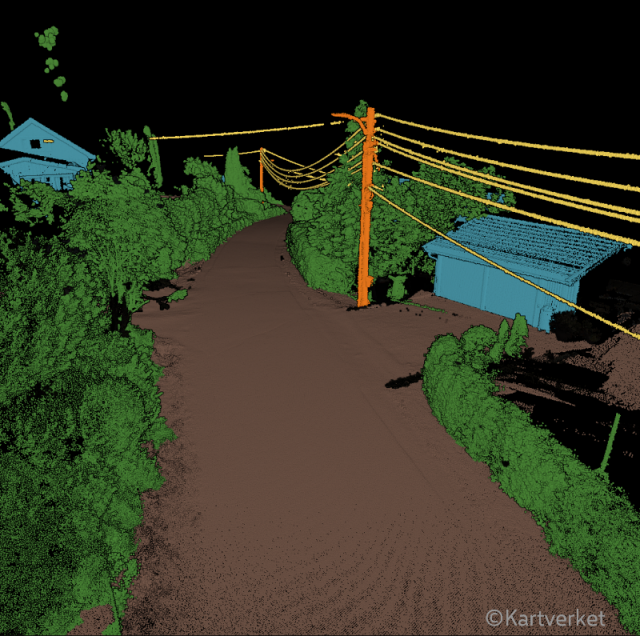
Pointly is an intelligent, cloud-based B2B software solution to manage and classify big data in 3D point clouds. Our innovative AI techniques enable an automatic as well as accelerated manual classification of data points within point clouds – making it faster and more precise for you than ever before.
Pointly GmbH
Berlin, DE
Description
Fast manual labeling
Using innovative AI approaches, points that belong together can be selected with minimal effort and high accuracy. With the automatically pre-processed segments, you can apply classification to complex objects with just a few clicks.
Standard Classifiers
By building on deep learning, we train standard classifiers for semantic segmentation. With a steady input of training data, the standard classifiers will be able to automatically classify your point clouds for certain use cases such as:
- Airborne Laser Scans
- City Inventories & Urban Objects
- Highway Scans
Benefit from automatic point cloud object classification right upon uploading your data.
Custom Classifiers
Make use of our Pointly 3D Point Cloud Services to train a custom classifier, should our standard classifiers not meet the requirements of your cloud data. Our custom classifiers are trained explicitly for the specific needs of our clients.
These classifiers are fully customizable for the proper visualization and analysis of your data. By supplying it with enough information, the custom classifier is able to automatically recognize the fitting class for your point cloud on upload.
We also offer Training Data Generation as Labeling Services to create the perfect alignment of training data and AI model.
Secure Cloud Processing
Pointly uses Microsoft’s fast, flexible, and secure Azure Cloud Computing Services. The parallel processing architecture allows elastic and independently scalable processing of even extensive amounts of data.
Everything you need to use Pointly is Internet access and a browser. No installation is required – simply sign up and benefit from the power of cloud storage and computing.
There is no need to invest in building data centers, external hardware, or maintenance. “Point out what matters to you,” right out of the box.
Your data is safe with us. Building on Azure’s 256-bit AES encryption standard and advanced threat protection, we protect your information whether in storage or transit.
Your user identity is managed through Azure B2C and ensures that only you have access to your data.
Collaboration
Pointly allows multiple individuals to access a project or point cloud simultaneously. Share it with your clients or your team – our tool allows you to perform classifications on various point clouds at once from several end points.
Streamline work processes by applying tags to:
- add properties
- document a status
- assign tasks to team members
API & On-Premise Classification
Via an API you can access the point cloud classification to utilize standard as well as custom classifiers without using the Pointly interface. The classification models can also be implemented into other platforms.
Instead of using the Pointly point cloud classification through a cloud, you can also order the standard or custom classifiers as a software package on-premise, allowing you to directly run it on local computers on client side.
Specifications
-
Hardware/software requirements
-
RAM [GB]
4
HD [GB]
0
Use of GPU
N
Stereo Display
N
Stand-alone
Yes
List software environment, e.g. Microstation
Microsoft Azure cloud platform
-
Other
-
Support
personal email support
Training
Y
Typical applications
training data generation for AI models, large scale surveys, forest inventory creation, city inventory creation, utilities / power line classification
Distinguishing features
automatic classification with Standard and Custom Classifiers & easy manual classification
-
Files and Registering
-
Input formats
LAS, LAZ
Output formats
LAS, LAZ
Geo-referencing
Y
Automatic Target Detection
Y
Stitching multiple scans
N
-
Pre-processing and Automatic Filtering
-
Image matching facilities
N
Removal of individual outliers
Y
Removal of vegetation
Y
Removal of buildings
Y
Bare ground DEM generation
Y
-
Manual Measurements
-
3D Coordinates extraction
N
Length and Height
N
Angle
N
Distance
N
Area
N
-
Interoperability
-
Assigning colour from imagery to points
N
Image overlay on TIN
N
-
General
-
Year of initial introduction
2020
Year of last update
2022
Modules
Standard Classifiers for Point Cloud segmentation
Source of Point Clouds
Airborne Lidar, Indoor TLS, Outdoor TLS, Photogrammetric, Radar
Supported Systems
LAS/LAZ format
-
Analysis
-
Line of sight
N
Aspect and slope
N
Individual tree heights
N
Time series analysis
N
-
Automatically Generated Products
-
Regular Grid DEMs
N
Cross sections
N
TIN
N
Contour Lines
N
Break lines
N
Boundary detection of solids
N
Building footprints
N
Building roofs
N
3D City modelling
Output of point clouds with point-wise classification
-
Solid Modelling
-
Lines
N
Planes
N
Cubes
N
Spheres
N
Cylinders
N
NURBS
N
-
Visualisation and Editing
-
Zoom, pan and rotate
Y
Fly-throughs
Y
Adding Points
N
Removing Points
N
Point Reduction
N


