
BayesStripAlign
High performance strip adjustment for airborne, UAV, mobile and Sonar
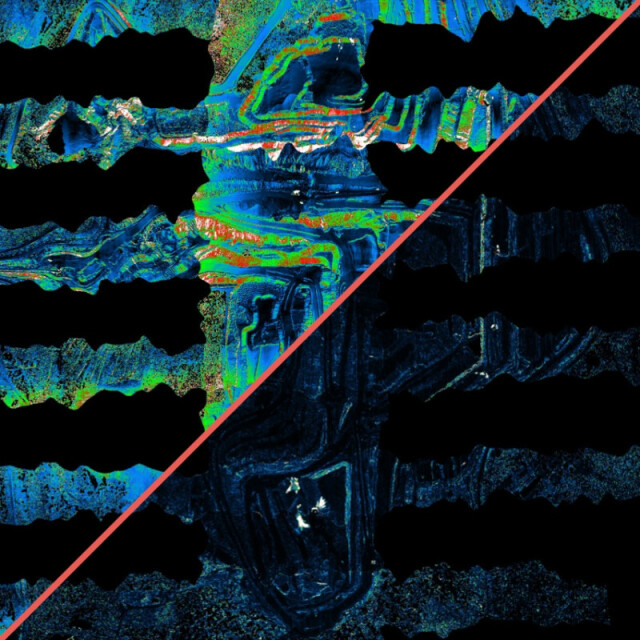
Perform LiDAR strip alignment faster and more accurately than existing software using advanced, fully automatic algorithms. No need to preprocess, classify or filter the data. From small scale UAV and mobile point clouds to very large scale airborne surveys, even topo-bathymetric data and Sonar, align anything! Also outputs QC maps, images, reports, logs, can use GCP, and much more...
Bayesmap Solutions
Le Rove, FR
Description
Input
- LAS/LAZ 1.4 or ASCII separate flight lines, projected
- SBET/SOL/TRJ/POF/ASCII position & orientation, projected or geodetic, flexible
- [GCP file] [parameters]
Output
- Corrected LAS/LAZ strips
- QC maps, images, stats, logs
- Updated PO and corrections
Features
- Fast point cloud registration compared to ICP or feature matching
- No flight line geometry restrictions, use all swath overlaps
- No classification required: robust to vegetation, viewpoint, changes, noise
- Effective relative accuracy improvement AND minimal absolute error
- Integrated boresight, lever arm and internal geometry calibration correction components help minimize biases
- High frequency trajectory/attitude drift corrections up to 2 Hz
- Automatic boresight and internal distortion calibration option without correction
- Multi-channel capability for scanners such as Riegl *1560
- Compatible with circular/elliptical and multi-beam scanners
- Large-scale and complex projects: use groups and match to reference datasets (such as 3DEP tiles)
- Useful LiDAR and PO files scanning module to check time sync and data consistency
- Fast QC with GCP, user friendly reports
- 3D error analysis, vector images, scatterplots, stats
- Z-differences, point density, hill shade, roughness, elevation maps
- Advanced corrections such as blending and warping available
- Simple command-line interface allows integration into complex workflows
- Multi-platform and cloud-compatible
- Flexible floating licensing system
- No dependencies - run on its own, simple to install
Coming soon…
New 3D registration algorithm able to register vegetation, vertical walls, overhangs and multiple surfaces, allowing accurate alignment of mobile mapping datasets, or complex UAV scenes
Specifications
-
Hardware/software requirements
-
Use of GPU
N
Processor
64-bit
Stand-alone
Yes
HD [GB]
32
List software environment, e.g. Microstation
none
RAM [GB]
4
Stereo Display
N
-
Other
-
Support
email support included in subscription
Distinguishing features
fast, robust, automatic
Training
Y
Typical applications
point cloud accuracy improvement
-
Files and Registering
-
Input formats
LAS LAZ ASCII
Output formats
LAS LAZ ASCII JPEG TIFF
Stitching multiple scans
Y
Geo-referencing
Y
Automatic Target Detection
Y
-
Pre-processing and Automatic Filtering
-
Removal of individual outliers
Y
Removal of vegetation
Y
Bare ground DEM generation
N
Image matching facilities
Y
Removal of buildings
N
-
Interoperability
-
Integration with other data types
Position/Orientation data (SBET, POF, SOL, TRJ, ASCII) and LAS/LAZ point clouds
-
General
-
Year of initial introduction
2016
Year of last update
2024
Source of Point Clouds
Airborne Lidar, Outdoor TLS
Modules
UAV, Airborne, Sonar, Mobile
-
Analysis
-
Aspect and slope
Y
-
Automatically Generated Products
-
Regular Grid DEMs
Y
Boundary detection of solids
N
Building roofs
N
Break lines
N
Building footprints
N
Contour Lines
N
Cross sections
Y
TIN
N


