
Reality Modeling Cloud Services
Quickly create, analyze, and share 3D models from anywhere
Reality Modeling Cloud Services includes: - ContextCapture Cloud Processing Service to quickly generate 3D engineering-ready reality meshes, orthophotos, digital surface models, and point clouds using ContextCapture Mobile or ContextCapture Cloud Processing Console. - ProjectWise ContextShare to securely manage, store, and share large amounts of reality modeling data across teams and applications.
Bentley Systems
Exton, US
Description
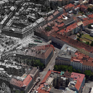
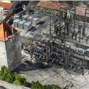
ContextCapture Cloud Processing Service enables you to upload photos and quickly generate 3D engineering-ready reality meshes, orthophotos, digital surface models, and point clouds. Without the need for high-end hardware requirements or IT constraints, you can simplify and scale your projects allowing anyone on your team to easily document as-is situations affordably, with less investment of time and resources, reducing your costs. Using a desktop or mobile application, you can access the cloud processing service.
ContextCapture Cloud Processing Console
This console enables you to instantly upload images, define your ContextCapture settings such as ground control points, and create a 3D reality mesh using the latest cloud technology.
ContextCapture Mobile
With this easy-to-use reality modeling app, you can quickly create 3D models using images taken with your phone or tablet and display the model on your device. The app is available on iOS and Android.
ProjectWise ContextShare is a reality modeling data sharing service that allows you to securely manage, store, and share large amounts of reality modeling data. Working in a connected data environment improves your workflow by sharing
and syncing your reality modeling data instantly across project teams and applications. Leverage capabilities such as Reality Data Web Viewer and ContextCapture Insights to streamline your inspection workflows.
Reality Data Web Viewer
This web-based collaborative tool adds value to your reality meshes. Easily link your reality mesh with asset data and annotate your scene.
Specifications
-
Feature Extraction and Mapping
-
Mapping facilities
N
Semi-automatic corner point extraction
N
Semi-automatic line feature extraction
N
Semi-automatic building extraction
N
3D superimposition
N
Integration with scanned maps
N
Integration with 2D vector maps
Y
Integration with 3D vector maps
Y
Integration with point clouds
Y
Automatic texturing
Y
-
Required Computer System
-
System includes hardware
Y
Operating system(s)
Azure cloud service
CPU (min.)
Intel® Xeon® Processor E5-2690 v3
CPU (preferred)
Intel® Xeon® Processor E5-2690 v3
Min. RAM memory [Mb]
56000
Preferred RAM memory [Mb]
56000
Min. graphic card
M60 GPU
Supported special hardware
all cameras and laser scanners
64-bit version of software available
Y
Distributed processing capacity
Y
Hardware handling of big data sets
M60 GPU
GPU based calculations
Y
-
Images and data
-
Source data
All kind of digital RGB image (digital camera, airborne, UAV/drone, smartphone) Thermal imagery Video Frames Up to 300Gpixel
Input image formats
JPEG, TIFF, RAW, JPEG2000, ECW (RGB and thermal) video frames extraction from: MP4, WMV, AVI, MOV and MPG files.
Export data formats
3D textured meshes: 3MX, S3C, OBJ, 3SM Orthophotos and DSM Pointclouds: LAS, POD Unique mesh with level of details: 3MX with LOD (large scene) Cesim 3D tiles Bentley Microstation: DGN Other available formats: FBX, DAE, STL, OSGB
Scanned analogue Aerial Photos
N
Digital Aerial Nadir Frames
Y
Oblique Images
Y
Linear array sensors
N
Optical Satellite Images
N
UAS Images
Y
Radar Images
N
-
DEMs & Orthoimages
-
Automatic breakline extraction
N
Checking facilities (DEM editing)
N
Automatic contour generation
Y
Mosaicing of orthoimages
N
True orthoimage generation
Y
Dense DSM creating capability
Y
DSM to DTM filtering
Y
Automatic seam line creation
N
Dense Image Matching
Y
-
Viewing System
-
Pref. display memory [Mb]
8000
-
General
-
Year of introduction
2017
Year of last update
2018
Modular
It consists of 2 modules: ContextCapture Cloud Processing Service and ProjectWise ContextShare
License configuration
Yes
Regional settings available
Yes
-
Orientation and triangulation
-
Automatic interior
Y
Relative
Y
Automatic aerotriangulation
Y
Automated blunder detection
Y
Self calibration
Y
images simultaneously processed
Y
-
Measurement tools
-
Length
Y
Area
Y
Volume
Y
-
Image manipulation & processing
-
Automatic contrast manipulations
Y
Spatial convolution
Y
Resampling
Y
Radiometric corrections
Y
Radiometric adjustment for mosaicing
Y
-
More information
-
Main applications
ContextCapture Console and ContextCapture Mobile
Distinguishable features
Can reconstruct textured 3D Reality Meshes from point clouds and images

![ELCOVISION-10[1].jpg](https://cdn.geo-matching.com/wRWm7Gyp.jpg?w=300&h=300&crop=1&s=d9595e4eab382ce38f888d623cb550d7)


