
PHOTOMOD UAS
Stand-alone full photogrammetric UAS-oriented software
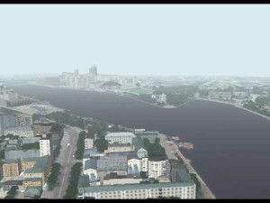
PHOTOMOD UAS is a stand-alone full photogrammetric UAS-oriented software that allows the user to process UAS data and acquire all types of value-added photogrammetric products: DEM, 2D and 3D-vectors, orthomosaics.
Racurs
Moscow, RU
Description
PHOTOMOD UAS is a stand-alone full photogrammetric UAS-oriented software allows the user to process UAS data and acquire all types of value added photogrammetric products: DEM, 2D and 3D-vectors, orthomosaics.
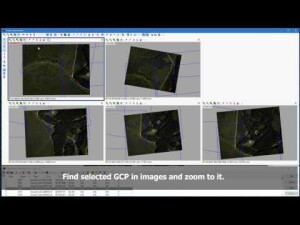
The main techniques of UAS data processing in the PHOTOMOD system are rigorous photogrammetric processing of images with accuracy comparable with ground sample distance (GSD), and simplified method with absolute accuracies of about tens of meters. Functionality, high performance, simplified user-friendly interface and automation of photogrammetric operations are key benefits, allowing the user to consider PHOTOMOD UAS as the optimal solution for UAS data processing. The system allows the user to improve processing performance due to distributed processing approach, and uses most effectively the computational capabilities available. Block layout creation, cutlines building, tie points search and measurement, as well as DEM building and filtering are available in the system in fully automatic mode.
PHOTOMOD UAS advantages
- PHOTOMOD UAS allows the user to process UAS data and acquire all types of value added photogrammetric products: DEM, dDSM, 2D and 3D-vectors, orthomosaics.
- Complete image data processing workflow without third party products.
- Functionality, high performance, simplified user-friendly interface and automation of photogrammetric operations are key benefits, allowing the user to consider PHOTOMOD as the optimal solution for UAS data processing.
UAS projects processing
- The main techniques of UAS data processing in the PHOTOMOD system are rigorous photogrammetric processing of images with accuracy comparable with ground sample distance (GSD), and simplified method with absolute accuracies of about tens of meters.
- While there are many advantages of an unmanned survey, the features of the UAV data pose serious problems for photogrammetric processing. The low quality of images, the low accuracy of the on-board GPS / IMU data, the use of uncalibrated consumer cameras and bugs related to the instability of the flight — all this required adding to the PHOTOMOD system special tools to neutralize these disadvantages and to obtain high-quality deliverables.
Support and Training
- Ease of use: you are guided step-by-step through all stages of project processing.
- Prompt and effective technical support.
- Chinese, English, Greek, Russian, Spanish localizations.
- Full user manual.
- An international dealer network helps us to market, sell and support our products in 80 countries.
Specifications
-
Feature Extraction and Mapping
-
Mapping facilities
Y
Semi-automatic corner point extraction
Y
Semi-automatic line feature extraction
Y
Semi-automatic building extraction
Y
3D superimposition
Y
Integration with scanned maps
Y
Integration with 2D vector maps
Y
Integration with 3D vector maps
Y
Integration with point clouds
Y
Automatic texturing
N
-
Required Computer System
-
System includes hardware
N
Operating system(s)
Microsoft Windows
CPU (preferred)
Intel Core i7
Preferred RAM memory [Mb]
32
Preferred data storage capacity [Gb]
4000
64-bit version of software available
Y
Distributed processing capacity
Y
GPU based calculations
Y
-
Images and data
-
UAS Images
Y
-
DEMs & Orthoimages
-
Automatic matching
Y
Automatic breakline extraction
N
Checking facilities (DEM editing)
Y
Automatic contour generation
Y
Mosaicing of orthoimages
Y
True orthoimage generation
N
Dense DSM creating capability
Y
DSM to DTM filtering
Y
Automatic seam line creation
Y
Dense Image Matching
Y
-
General
-
Year of introduction
2015
Year of last update
2019
License configuration
Lite, time-limited, cloud
Regional settings available
English, Chinese, Greek, Russian, Spanish
-
Orientation and triangulation
-
Automatic interior
Y
Relative
Y
Automatic aerotriangulation
Y
Automated blunder detection
Y
Self calibration
Y
images simultaneously processed
Y
Automatic Relative
Y
-
Measurement tools
-
Length
Y
Area
Y
Volume
Y
-
Image manipulation & processing
-
Automatic contrast manipulations
Y
Spatial convolution
Y
Radiometric corrections
Y
Radiometric adjustment for mosaicing
Y
-
More information
-
Distinguishable features
Professional photogrammetric UAS-oriented software

![ELCOVISION-10[1].jpg](https://cdn.geo-matching.com/wRWm7Gyp.jpg?w=300&h=300&crop=1&s=d9595e4eab382ce38f888d623cb550d7)


