
PhotoMesh - 3D Geospatial Authoring Tool
Fully automated generation of high-resolution large scale 3D models from standard photographs.
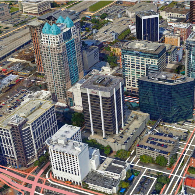
PhotoMesh fully automates the generation of high-resolution, textured, 3D mesh models from standard 2D photographs. This breakthrough application combines unlimited scalability with superior precision to produce consistent and accurate 3D models that enhance the realism of any 3D visualization.
Skyline Software Systems
Herndon, US
Description
Skyline’s PhotoMesh fully automates the generation of high- resolution, textured, 3D mesh models from standard 2D photographs, offering a significant reduction in cost and time compared to traditional modeling methods. PhotoMesh’s breakthrough technology is based on the highest-performance photogrammetry, computer vision, and computational geometry algorithms. Combining any number of photographs, in a wide range of formats and resolutions, PhotoMesh generates highly-detailed 3D models that can be viewed and queried using TerraExplorer or other 3D, GIS products. PhotoMesh employs elaborate tiling mechanisms to efficiently handle projects with even hundreds of thousands of photos. Running on standard hardware, PhotoMesh can also exploit computer clusters and cloud computing to accelerate database creation. A single project can run simultaneously on hundreds of fuser machines, each processing different build steps and communicating with PhotoMesh Manager.
Specifications
-
Feature Extraction and Mapping
-
Mapping facilities
Y
Semi-automatic corner point extraction
Y
Semi-automatic line feature extraction
Y
Semi-automatic building extraction
N
3D superimposition
Y
Integration with scanned maps
N
Integration with 2D vector maps
N
Integration with 3D vector maps
N
Integration with point clouds
Y
Automatic texturing
yes
-
Required Computer System
-
System includes hardware
N
Operating system(s)
Windows
CPU (min.)
I7
CPU (preferred)
I9
Min. RAM memory [Mb]
16
Preferred RAM memory [Mb]
32
64-bit version of software available
Y
Distributed processing capacity
Y
GPU based calculations
Y
Min. graphic card
on board
Hardware handling of big data sets
GEForce - Nvidia
User definable operations and extensions
available API
-
Images and data
-
Source data
aerial, drone, terrestrial
Input image formats
jpg, tif
Export data formats
3DML, 3D Tiles (Cesium), I3S, OBJ, DAE, OSGB, GEOTIF, LAS
Scanned analogue Aerial Photos
N
Digital Aerial Nadir Frames
Y
Oblique Images
Y
Linear array sensors
N
Optical Satellite Images
N
UAS Images
Y
Radar Images
N
-
DEMs & Orthoimages
-
Automatic matching
yes
Automatic breakline extraction
Y
Checking facilities (DEM editing)
N
Automatic contour generation
N
Mosaicing of orthoimages
N
True orthoimage generation
Y
Dense DSM creating capability
Y
DSM to DTM filtering
Y
Automatic seam line creation
N
Dense Image Matching
Y
-
General
-
Year of introduction
2014
Year of last update
2019
Regional settings available
American, European
License configuration
stand alone, multi-computer, cloud
-
Orientation and triangulation
-
Automatic interior
Y
Relative
Y
Automatic aerotriangulation
Y
Automated blunder detection
Y
Self calibration
Y
images simultaneously processed
Y
Automatic Relative
yes, no gps input required
-
Measurement tools
-
Length
Y
Area
Y
Volume
Y
-
Image manipulation & processing
-
Automatic contrast manipulations
Y
Spatial convolution
Y
Resampling
Y
Radiometric corrections
Yes
Radiometric adjustment for mosaicing
Y
-
More information
-
Main applications
3D reconstruction from variable image sources & integration with LiDAR
Distinguishable features
unlimited scale, high quality optimization, customizable API for unique workflows
![ELCOVISION-10[1].jpg](https://cdn.geo-matching.com/wRWm7Gyp.jpg?w=300&h=300&crop=1&s=d9595e4eab382ce38f888d623cb550d7)


