ContextCapture Center
Quickly create 3D reality meshes from photos and/or point clouds
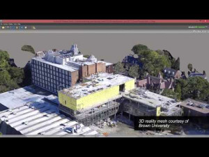
ContextCapture enables you to use ordinary photographs to cost effectively produce 3D models of the most challenging existing conditions for every infrastructure project. For additional accuracy, adding point clouds from laser scans results in fine details, sharp edges, and geometric precision. You can quickly create and use these highly detailed 3D reality meshes to provide precise real-world context for design, construction, and operations decisions throughout the lifecycle of projects.
Bentley Systems
Exton, US
Description
Create 3D Engineering-ready Reality Meshes
With ContextCapture, you can cost effectively produce 3D models of the most challenging existing conditions for use on every infrastructure project, using ordinary photographs. You can add point clouds for additional accuracy resulting in fi ne details, sharp edges, and geometric accuracy. You can quickly create and use these highly detailed 3D reality meshes to provide precise real-world context for design, construction, and operations decisions for use throughout the lifecycle of projects.
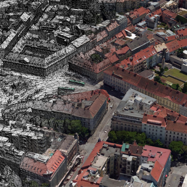
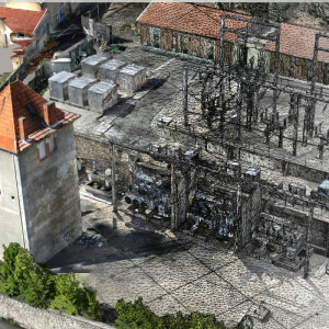
ContextCapture allows you to reliably and quickly produce 3D models of any scale, from objects of a few centimeters to entire cities. The only limit in the precision of the resulting 3D model is the resolution of the input data.
Affordable, Precise 3D Models
You can affordably develop precise reality meshes faster without investing time and resources in specialized acquisition devices and associated training, since ordinary cameras are all that is required.
Confidence to Model any Scale Project
You can confidently and reliably deliver highly detailed models of any scale, faster than before due to ContextCapture’s use of general-purpose computation on graphics processing units (GPGPU) as well as multi-core computing. ContextCapture can process about 20 gigapixels per day, per computer.
Integrate Models into any Workflow
You can access and share these richly photo-textured 3D models of existing conditions in any CAD or GIS workfl ow on desktop and mobile devices, in many formats, including for native use within MicroStation® and other Bentley applications.
ContextCapture Product Line
Depending on your reality modeling workflow needs, ContextCapture is available as an on premise or cloud-processing service solution.
ContextCapture has three main modules master, engine, and editor. The master module provides a graphical user interface that allows you to define input data, processing settings, submit processing tasks, monitor progress, and visualize results. The engine module runs on a computer in the background, without user interaction, and performs the computationally intensive algorithms. This master-worker pattern allows ContextCapture to support grid computing and dramatically reduces processing time simply by running multiple ContextCapture engines on several computers and working on a shared job queue. ContextCapture Editor is a 3D CAD module for editing and analyzing reality data and is included with ContextCapture and ContextCapture Center.
You can quickly produce reality meshes using your local machine or upgrade to ContextCapture Center to save time by employing scalable computing power to speed production of your 3D models leveraging the latest parallel computing systems.
ContextCapture vs ContextCapture Center
When creating extremely large models, take advantage of greater computational power with ContextCapture Center. It adds the capability to leverage grid computing to dramatically speed processing time by running multiple engines on several computers, and associating them to a single job queue. If you have projects larger than 300 gigapixels of imagery, use ContextCapture Center to seamlessly handle terabytes of input imagery.
You can speed production using the latest computing systems for desktop and cluster processing units, including leveraging GPU computing, multi-core computing, advanced bundle block adjustment, tiling mechanisms, task queuing and monitoring, grid computing, and ultra-large project management.
| CAPABILITIES | CONTEXTCAPTURE | CONTEXTCAPTURE CENTER |
|---|---|---|
| Imagery dataset size per project | Up to 300 Gigapixels | Unlimited |
| Scanned point clouds limitation per project | 3 Billion | Unlimited |
| Mesh export formats (3MX/3SM/DGN/I3S/OBJ/FBX/STL/DAE/OSGB/Cesium) | * | * |
| Colored point cloud export (POD/LAS) | * | * |
| True orthophoto / 2.5D Digital Surface Model (TIFF/GEOTIFF/KML) | * | * |
| Georeferencing | * | * |
| Parallel (cluster) processing for unlimited scalability | * | |
| Software development kit | * | * |
Specifications
-
Feature Extraction and Mapping
-
Mapping facilities
N
Semi-automatic corner point extraction
N
Semi-automatic line feature extraction
N
Semi-automatic building extraction
N
3D superimposition
N
Integration with scanned maps
N
Integration with 2D vector maps
Y
Integration with 3D vector maps
Y
Integration with point clouds
Y
Automatic texturing
Y
-
Required Computer System
-
System includes hardware
N
Operating system(s)
Microsoft Windows 7/8/10
CPU (min.)
Any CPU
CPU (preferred)
Intel I7 (4+ cores), 4.0+ Ghz
Min. RAM memory [Mb]
8000
Preferred RAM memory [Mb]
64000
Min. graphic card
Any (Nvidia Tesla: from M serie only)
Supported special hardware
All camera support and point clouds
User definable operations and extensions
SDK / Python Scripting
64-bit version of software available
Y
Distributed processing capacity
Y
GPU based calculations
Y
Hardware handling of big data sets
NVIDIA GeForce GTX 1080 Ti or TitanX, GTX1080
-
Images and data
-
Source data
All kind of digital RGB image (digital camera, airborne, UAV/drone, smartphone)Thermal imageryVideo FramesUnlimited size
Input image formats
JPEG, TIFF, RAW, JPEG2000, ECW (RGB and thermal)video frames extraction from: MP4, WMV, AVI, MOV and MPG files.
Export data formats
3D textured meshes: 3MX, S3C, OBJ, 3SMOrthophotos and DSMPointclouds: LAS, PODUnique mesh with level of details: 3MX with LOD (large scene)Cesim 3D tilesBentley Microstation: DGNOther available formats: FBX, DAE, STL, OSGB
Scanned analogue Aerial Photos
N
Digital Aerial Nadir Frames
Y
Oblique Images
Y
Linear array sensors
N
Optical Satellite Images
N
UAS Images
Y
Radar Images
N
-
DEMs & Orthoimages
-
Automatic breakline extraction
N
Checking facilities (DEM editing)
N
Automatic contour generation
Y
Mosaicing of orthoimages
N
True orthoimage generation
Y
Dense DSM creating capability
Y
DSM to DTM filtering
Y
Automatic seam line creation
N
Dense Image Matching
Y
-
Viewing System
-
Pref. display memory [Mb]
8000
-
General
-
Year of introduction
2013
Year of last update
2017
Modular
Depending on your reality modeling workflow needs, ContextCapture is available as an on premise or cloud processing service solution. ContextCapture has two main modules, the master and the engine, in addition to an editor module.
License configuration
Yes, (7 days trial available)
Regional settings available
Yes
-
Orientation and triangulation
-
Automatic interior
Y
Relative
Y
Automatic aerotriangulation
Y
Automated blunder detection
Y
Self calibration
Y
images simultaneously processed
Y
-
Measurement tools
-
Length
Y
Area
Y
Volume
Y
-
Image manipulation & processing
-
Automatic contrast manipulations
Y
Spatial convolution
Y
Radiometric corrections
Y
Radiometric adjustment for mosaicing
Y
-
More information
-
Main applications
With ContextCapture, you can cost effectively produce 3D models of the most challenging existing conditions for use on every infrastructure project, using ordinary photographs. You can add point clouds for additional accuracy resulting in fi ne details, sharp edges, and geometric accuracy. You can quickly create and use these highly detailed 3D reality meshes to provide precise real-world context for design, construction, and operations decisions for use throughout the lifecycle of projects. Applications: Surveying/mining/Inspection/Construction/Forensics/Earthworks/Environmental monitoring.
Distinguishable features
- Parallelizable processing (multi machines) and cloud processing available- Supports point clouds (unlimited size) for hybrid reality model creation (point clouds and photos)- SDK / python scripting to implement ContextCapture in a global processing workflow- Unique Mesh export with LOD, for faster handling of wide scenes (city, region)- Reconstruction constraints (water, surfaces...)- Quality Control- Unlimited input data size- Free viewer/web publishing- CAD and 3D GIS interoperability- Supports thermal camera (far infrared) images- Supports multi GPU on a single machine- Efficient Color equalization algorithm- Rig support (multi-camera systems)

![ELCOVISION-10[1].jpg](https://cdn.geo-matching.com/wRWm7Gyp.jpg?w=300&h=300&crop=1&s=d9595e4eab382ce38f888d623cb550d7)


