Stencil Pro
Pro-grade mobile laser scanner delivers impressive dimensional & visual fidelity: 360°COLOR • RUGGED • GEO-ENABLED • HIGH DENSITY • VERSATILE
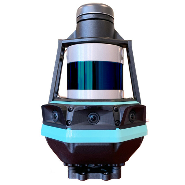
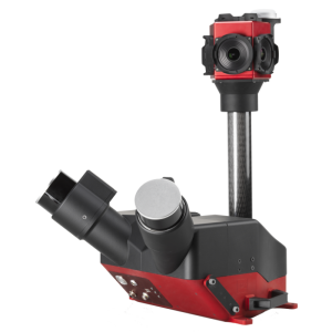
Stencil Pro is the innovative mobile mapping platform that goes anywhere – in just about any environment – giving you rapid, accurate, and visually stunning reality capture. An all-in-one system to scan, process, and view captured data in real time, Stencil Pro offers integrated GNSS, panoramic 4K imagery and colorized point clouds in an IP65-rated professional form factor.
Kaarta
Description
Kaarta Stencil® Pro is the innovative mobile mapping platform that goes anywhere – in just about any environment – giving you rapid, accurate, and visually stunning reality capture. An all-in-one system to scan, process, and view captured data in real time, Stencil Pro offers integrated GNSS, panoramic 4K imagery, and colorized point clouds in an IP65-rated professional form factor. With robust surround-view perception in a wide range of light conditions, Stencil Pro is optimized for both indoor and outdoor performance. Featuring an impressive 32-line high-density, low-noise lidar with a range of 120m and a data rate of 600,000 points per second, Stencil Pro produces a highly accurate 3D map in minutes. New advancements are backed by proven Kaarta technology, quality, and accuracy.
An IP65-rating makes Stencil Pro a workhorse in infrastructure mapping, mining, forestry, earthworks, construction, and other harsh environments. Stencil Pro’s rugged and versatile design is adaptable to many environments, capturing data amidst poor weather, dusty work environments, and below-ground cavities.
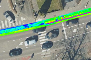
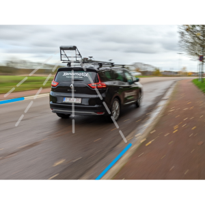
The combination of high-resolution 3D perception and a broad vertical field of view enables Stencil Pro to accurately detect ground-level surfaces as well as overhead elements, mapping detail such as curbs, manholes, signs, and poles. The durable configuration makes Stencil Pro ideal for vehicle-mounted applications, resulting in extremely fast surveys for large-scale projects.
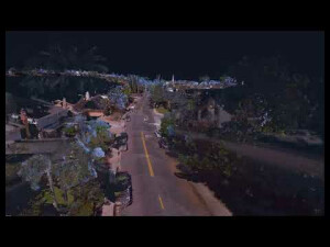
An added benefit of Stencil Pro is its acquisition of high resolution 360° imagery with four 8-megapixel color cameras, enhancing an already comprehensive 3D model by creating a visual record of current project conditions, as-built environments, and corridor mapping projects. The integration of 3D and high-quality imagery data can improve or speed up the object identification process utilized by geospatial or machine-based learning applications and real-time change detection when compared to point cloud data alone.
Stencil Pro incorporates leading-edge components like a Velodyne Ultra Puck VLP-32C lidar, four >90° RGB cameras (full stitched panorama), and a 6 DoF IMU. Stencil Pro uses simultaneous mapping and localization in GNSS-denied environments but also has an integrated Trimble GNSS receiver to achieve best-in-class, low-drift accuracy while mapping over longer ranges. GNSS data is collected, corrected via PPK or RTK, and then used to align and geo-register data, providing global accuracy and further enhancing the fidelity of large-area scans and long, linear scan paths. To further improve GNSS quality, Stencil Pro is configured with seven constellations for worldwide coverage: GPS, GLONASS, Galileo, BeiDou, QZSS, IRNSS, and SBAS.
Stencil Pro’s intuitive user interface makes data capture and processing simple. The user experience includes one-button scanning, real-time scan monitoring, and streamlined post-processing options for maximizing data clarity and usability. Remote operation using the touchscreen monitor or the controller’s start/stop scan button allows for mounting Stencil Pro on a multitude of transports. When hand-carrying, scan status can also be started and stopped with a push of a button on the device.
With Stencil Pro’s high density, multi-sensor capture comes sizeable outputs. Stencil Pro was developed with transferability in mind. Multiple ports support large data transfers, including a high-speed ethernet adapter. Stencil Pro is also WiFi-enabled for built-in connectivity and cloud readiness.
Stencil Pro is a turnkey system advancing next-generation mobile surveying.
Specifications
-
General
-
Year of initial introduction
2020
Year of last update
2022
Application
Outdoor
-
Positioning
-
GNSS receiver: Brand and model
Integrated Trimble BD-990 receiver
Number of antennas
1
Tracked GNSS signals
GNSS data is collected, corrected via PPK or RTK; Stencil Pro is configured with seven constellations for worldwide coverage: GPS, GLONASS, Galileo, BeiDou, QZSS, IRNSS, and SBAS
IMU: Brand and model
Internal MEMS-based IMU Six DoF: X, Y, Z, Roll, Pitch, Yaw
Ground control point integration supported
Y
-
Lidar Sensor
-
Brand
Velodyne ultra puck VLP-32c
Number of laser scanners
1
Laser safety classification
Class 1 Eye-safe per IEC 60825-1:2014
Min. Range [m]
1
Max Range [m]
200
Max. vertical field of view [deg]
40
Scans per second
600
-
Operation
-
Distinguishing features
SLAM-based mobile mapping, works in GNSS-denied environments, but also has an integrated Trimble GNSS receiver to achieve best-in-class, low-drift accuracy while mapping over longer ranges. Panoramic color images produce RGB point cloud.
Main applications
infrastructure mapping, mining, forestry, earthworks, construction and other harsh environments; large interiors such as warehouses
Training provided
Y
-
Camera System
-
Brand and model
Integrated cameras
Number of cameras
5
CCD size [.. x .. pixels]
1 High-frame rate B/W Camera for visual odometry (4 MP) 4 Panoramic high-resolution 4K color cameras (8 MP), each camera with >90° HFOV and 55° VFOV provide full stitched 360° panorama (max resolution of panorama is 10K+)
FoV per camera [deg]
360
Export formats
.ply, .las
-
Dimensions & Environment
-
Size with case
scanner head: 290mm x 178mm x 181mm, control pack: 342mm x 121mm x 205mm
Weight [kg]
3.4
Min. Operation temp. [°C]
-10
Max. Operation temp. [°C]
45
Max. humidity [%]
96
-
Included Processing Software
-
Laser Point Clouds Software
Kaarta Engine
Other Software
Cloud Compare
-
Control Unit
-
Processor
Intel NUC i7 Octa Core
Size hard disk [GB]
1000
WiFi
Y
I/O port(s)
1 HDMI, 2 USB-A, 1 USB-C


