
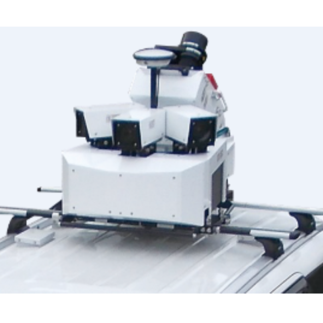
Mitsubishi MMS-G
Mitsubishi Electric has released a new, compact, survey-grade and easy-to-use mobile mapping system
An advanced solution to capture high precision, spatial data for general surveying, detailed asset management and HD maps for safe, autonomous driving.
Mitsubishi Electric
Cypress, US
Description
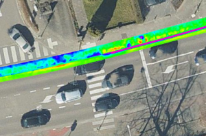
- Easily create a survey grade and high density 3D point cloud
- Detachable and highly portable
- Easy operation and post processing
- Various application possible in Asset Management (Road pavement inspection, Tunnel wall inspection etc.)
Specifications
-
General
-
Application
Outdoor
Year of last update
2019
-
Positioning
-
Tracked GNSS signals
GPS, GLONASS, Galileo
GNSS receiver: Brand and model
Novatel
Number of antennas
1
IMU: Brand and model
KVH
Wheel sensor: Brand and model
Kistler
Number of wheel sensors
1
Ground control point integration supported
Y
-
Lidar Sensor
-
Number of laser scanners
1
Max Range [m]
119
Max. vertical field of view [deg]
360
Brand
Z+F Profiler
Laser safety classification
Class1
Max. measurement rate [kHz]
1000
Scans per second
200
Export formats
.LAS
-
Operation
-
Distinguishing features
Use easily is the most important concept of Mitsubishi Electric's MMS-G (Mobile Mapping System). This high grade survey equipment enables to be operated by a beginner as same as home appliances. This equipment has just 4 major button to record professional 3D model around you.Highly accurate calibration is one of our proud in MMS-G(Mitsubishi Electric's Mobile Mapping System) production. Our MMS-G were tuned in the same facility of space satellite and militaly products by the same grade quality policy.In the result, the laser point cloud and camera image are overlapped very well to extract feature of various objects.
Training provided
Y
Max. speed [km/hr]
100
Main applications
Survey, Mapping and Assets inventory
-
Camera System
-
Number of cameras
4
Spectral Bands [PAN, RGB, NIR, CIR]
RGB
CCD size [.. x .. pixels]
2448 x 2048
Export formats
.JPG, .RAW
-
Dimensions & Environment
-
Weight [kg]
55
Size with case
120*100*120cm(Main Unit) & 80*80*80cm(Laser Unit)
Min. Operation temp. [°C]
-10
Max. Operation temp. [°C]
40
-
Included Processing Software
-
Photogrammetry Software
In-house developed software
Laser Point Clouds Software
In-house developed software
Other Software
Automated positionig optimization/ GCP correction software (In-house developed)
-
Control Unit
-
Computer
Industrial Usage
Size hard disk [GB]
3000
WiFi
N

