Mapping historical sites to mining sites – Turning LiDAR data into valuable insights
Wed, Sep 30, 2020 at 6:00 PM (UTC)
1 hour
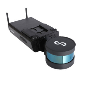
Emesent partner, AMKVO, delivers drone and remote sensing services throughout Sweden. Having performed more than 25,000 flights, Alex Paulusson, AMKVO CEO, will share insights how they are using Hovermap in mining and infrastructure projects.

Following a serious seismic event at LKAB’s Kiruna mine, AMKVO used Hovermap to inspect the damage. Mapping kilometers of the affected areas took only a few days and mine personnel were not exposed to any risks.
Historical site, Kalmar castle, required up-to-date data prior to preservation activities. Alex mapped these heritage buildings with Hovermap to produce accurate, colorized digital twins.

Related products