Introducing the Trimble MX50 Mobile Mapping Solution
Thu, Jul 29, 2021 at 4:00 PM (UTC)
1 hour
Join Trimble for a webinar overview of the latest Trimble solution for mobile mapping and learn how whether for highway management, utilities, or local government the Trimble MX50 puts you in control of your data capture project.

Presenter: Viktoriia Gadaichuk, Jacek Pietruczanis, Peter Houghton
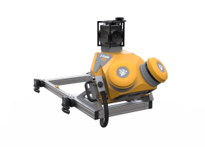
Mobile Scanning & Imaging for Asset Management & Road Maintenance
The Trimble MX50 is a practical field-to-finish mobile mapping solution for asset management, mapping, and road maintenance. The system delivers a very accurate point cloud of the environment along with complimentary immersive imagery providing substantial gains in productivity.
Join us for a webinar overview of the latest Trimble solution for mobile mapping and learn how whether for highway management, utilities, or local government the Trimble MX50 puts you in control of your data capture project.

Related products