
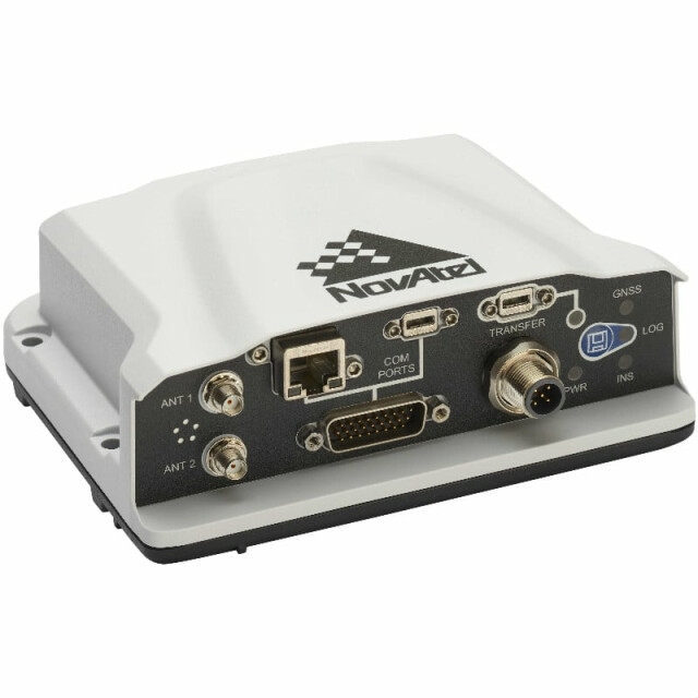
PwrPak7D-E1
The PwrPak7D-E1 is a robust, high-precision receiver that has multi-frequency, dual antenna input and provides industry leading Global Navigation Satellite System (GNSS) multi-constellation heading and position data.

NovAtel
Calgary, CA
Description
The PwrPak7D-E1 is a robust, high-precision receiver that has multi-frequency, dual antenna input and provides industry leading Global Navigation Satellite System (GNSS) multi-constellation heading and position data.
These capabilities make the PwrPak7D-E1 ideal for ground vehicle, marine or aircraft based systems. NovAtel’s world class Synchronous Position, Attitude and Navigation (SPAN®) technology brings together GNSS positioning and inertial navigation to provide an exceptional 3D navigation solution that is stable and continuously available.
The PwrPak7D-E1 has a powerful OEM7® GNSS engine, integrated Epson G320N MEMS IMU, built-in Wi-Fi, on board NTRIP client and server support and 16 GB of internal storage.
Do you have questions about this product?
- Questions about price, availability, and/or retailers
- Questions about technical specifications and usage
- Questions about suitability for your project or application
Specifications
-
Other specifications
-
Graphical user interface
Y
Typical application
ideal for ground vehicle, marine or aircraft based systems.
Distinguishable features
+ SPAN enabled enclosure featuring NovAtel’s tightly coupled GNSS+INS engine + Enhanced connection options including serial, USB, CAN and Ethernet + 555 channel, all-constellation, multi-frequency positioning solution + Multi-channel L-Band supports TerraStar correction services + Multiple communication interfaces for easy integration and installation + Built-in Wi-Fi support + 16 GB of internal storage + ALIGN® heading solution
Export restrictions
Export licensing restricts operation to a maximum of 515 meters per second, message output impacted above 500 m/s.
-
Environmental
-
Non-operating shock tolerance [g]
40
-
Software
-
Filtering
Y
Adaptable input signals
Y
-
GNSS aided uncertainty
-
Heading [deg]
0.09
Pitch [deg]
0.02
Roll [deg]
0.02
-
General
-
Year of initial development
2018
Height [m]
0.05
Width [m]
0.125
Length [m]
0.147
Weight [kg]
0.51
Min. Voltage (DC)
9
Max. Voltage (DC)
36
Power consumption [W]
1.8
Splashproof casting
Y
Water resistant casting
Y
Removable from base plate
Y
Type of application
Marine
Type of accelerometer
Epson G320N MEMS IMU
Type of gyro
Epson G320N MEMS IMU
-
GNSS Positioning Sensor
-
No. channels p receiver
555
Tracked satellite signals
GPS L1 C/A, L1C, L2C, L2P, L5 GLONASS3 L1 C/A, L2 C/A, L2P, L3, L5 BeiDou4 B1, B2 Galileo E1, E5 AltBOC, E5a, E5b NavIC (IRNSS) L5 SBAS L1, L5 QZSS L1 C/A, L1C, L2C, L5 L-Band up to 5 channels
SBAS differential signals
Y
RTK Network Compatibility
Y
Update rate [ Hz ]
20
Cold start [ seconds ]
40
Hot start [ seconds ]
19
-
Inertial Measurement Unit
-
Accelerometer bias [µ-g]
0.1
gyro bias [deg/hr]
3.5
-
GNSS positional accuracy
-
Horizontal Position Accuracy [ RMS in cm ]
120
Horizontal Position Accuracy (SBAS) [ RMS in cm ]
60
Horizontal Position Accuracy (RTK) [ RMS in cm ]
1
Documents
Brochure
pwrpak7d


