Hydromagic Survey
Hydromagic Is a Single Beam Hydrographic Survey Software Package That Provides All You Need to Start Surveying Today
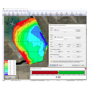
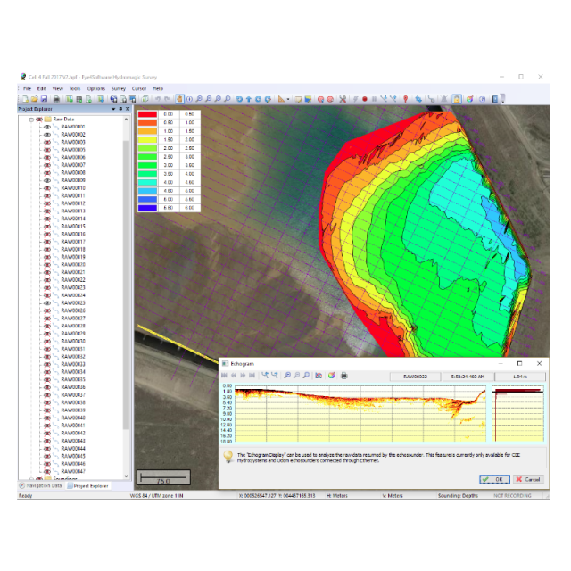
Eye4Software Hydromagic Survey is a cost effective, easy to use hydrographic data acquisition and processing software package for Windows. The software has a short learning curve and has been designed to allow both experienced and novice (non surveyor) users to perform hydrographic data acquisition and produce final products from a single software package. The package contains tools for data acquisitions, as well as tools for data cleansing, echogram digitizing, processing and exporting.

Eye4Software
Wolvega, NL
Description
Hydromagic Survey is a user friendly, easy to use data acquisition and processing package for Windows.
It has been designed to allow less experienced (non surveyor) users to perform soundings and produce final products from a single software package.
Do you have questions about this product?
- Questions about price, availability, and/or retailers
- Questions about technical specifications and usage
- Questions about suitability for your project or application
Specifications
-
General
-
Year of initial development
2009
Year of latest version
2023
Operating System
Windows
Area of Application
Hydrographic Survey, Bathymetric Survey, Vessel Positioning, Research and Development, Underwater Archeology
-
Geodetic Functionality
-
Supported coordinate systems
Universal Transverse Mercator, State Plane Coordinate System, Local Coordinate Systems, EPSG database lookup, local construction grids (mining grids)
Supported datum transformations
Helmert, Molodensky, Local Datum Correction Grids (NTv2) and HTDP
Geographical coordinates (Lat, Long)
Y
Ground coordinates (E,N)
Y
Seven Parameter shift supported
Y
Time-dependent Transformation Parameters (14param)
Y
Supported vertical reference frames
NAVD88, NAP, TAW and more
Ellipsoidal reference support (GRS80)
Y
Separation model for vertical datum shift support
Y
Local datum support
Y
Supported map projections
Universal Transverse Mercator, State Plane Coordinate System, Tranverse Mercator, Lambert Conformal Conic, Oblique Sterographic, Polar Stereographic, Albers Equal Area, Bonne, Cassini Soldner, Krovak, Mercator, Polyconic, Oblique Mercator and more.
-
Data / System Support
-
Recorded data storage formats
RAW, ASCII, XYZ, AutoCAD DXF, PDF, PNG, GIF, JPG, ESRI Shape Files and Keyhole Markup Language (KML)
Supported Hydrographic Systems
Single Beam Dual Frequency Echosounders
Supported AUVs
CEE-USV, Teledyne Oceanscience Z-Boat, HydroBall and more
Supported singlebeam systems
Single and Dual frequency single beam echosounders
Supported motion sensor systems
TSS1
Supported sub-bottom Profiler systems
Syqwest Stratabox, Unabara Hydro-2F, SES2000 and more
Metadata management
Y
Supported total station systems
Trimble and Leica
-
Online capabilities
-
Helmsman display
Y
Supported background formats
Google Maps, Bing Maps, Georeferenced PNG/JPG/BMP/GIF images, IHO S(ENC), AutoCAD DXF, Microstation DGN, (Geo)TIFF, ESRI Shapefiles, ARC/Info, MapInfo, Atlas BNA, Idrisi, DLG-3, DLG-O, KML, OpenStreeMap XML,
Max number of online displayed surface vessels
1
RTK GPS height correction
Y
Supported 3D display data
Y
Type of navigation screens
Navigation, Helmsman, Echogram, Echosounder, Data
Real time video integration
Y
Real-time Pipe detection
N
Online eventing
Y
Real time tidal correction methods
RTK, Tide Gauge
-
Hardware requirements
-
RAM
2048
HD (GB)
32
Processor (CPU)
32-bit, 64-bit
Languages Supported
English
Documents
Brochure
14070-hydromagic-data-sheet-0.pdf
1.11 MB
More from Eye4Software