BeamworX Suite
Complete Software Suite for Acquisition and Processing of Single- and Multibeam Echosounder data
The BeamworX Software Suite is a complete Hydrographic Survey Package for the acquistion, calibration and processing of singlebeam, multibeam echosouder and lidar data.
BeamworX
utrecht, NL
Description
The BeamworX Software Suite is a complete Hydrographic Survey Package for the acquistion, calibration and processing of singlebeam, multibeam echosouder and lidar data.
It bundles all our modules into one installer.
Each software module is made available on an annual subscription basis.
This provides our clients a flexible and transparent way to use our software.
The following modules are available:
|
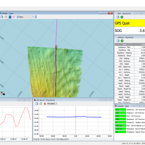
NavAQ |
Easy Echosounder Data Acquistion |
|
AutoClean |
User-friendly and robust point cloud cleaning program for Bathymetric and Lidar point data |
|
AutoPatch |
Fully automated Multibeam Echosounder patch test calculator |
|
SBEdit |
Easy to use Single Beam Echosounder Editor |
|
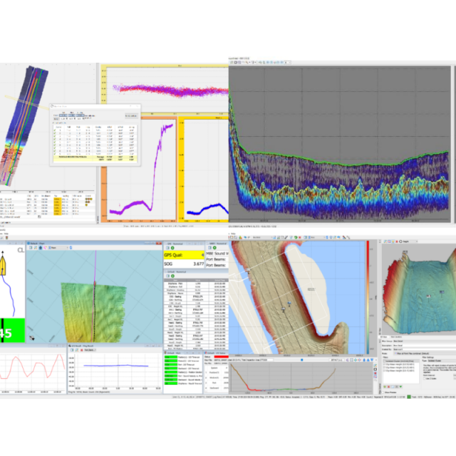
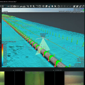
Raw Processing |
Fast Processing of any type of multibeam data |
Specifications
-
Hardware/software requirements
-
RAM [MB]
8000
HD{GB}
128
Use of GPU
Y
Processor
["64-bit"]
Stereo Display
N
Field of Use
Processing of Hydrographic Echosounder data and Point Clouds
Languages Supported
English
-
General
-
Year of last update
2019
Year of initial introduction
2015
Modules
NavAQ, AutoClean, AutoPatch, SBEdit, RawProcesing
Supported Systems (SB, MB, SSS, Lidar etc.)
SB, MB, Lidar
-
Processing
-
Tidal reduction
Tide, RTK-tide
Support tidal reduction network
N
Gridding/Interpolation techniques
Grid
Grid attributes {Std., Mean, Max, etc.}
SDEV, Mean, Min, Max, Count, Reject Count, Span, Survey Accuracy
Lay-back correction
N
Siant range correction
N
Mosaic creation
N
Mosaic creation algorithms
N/A
SSS Targeting
N/A
Number of video channels
0
Assessment of bathymetry IHO Cat S-44
Y
Type of automatic cleaning algorithm(s)
statistical, spline filter, spatial
Multibeam water column imaging support
N
Multibeam Backscatter Processing Functionality
N/A
Manual editing capability
Y
Sound velocity correction
Single profile support
Sound velocity correction type
Time
Video integration
N
Mulitbeam Calibration mehods
Auto
-
Geodetic Functionality
-
Supported coordinate systems
Full, through Proj4
Geographical Coordinates {Lat, Long}
Y
Ground Coordinates {E,N}
Y
Seven Parameter shift supported
Y
Supported vertical reference frames
Through Proj4
Separation model for vertical datum shift support
Y
Local datum support
Y
Ellipsoidal reference support (GRS80)
Y
-
Product Generation
-
Automatic top of pipe calculation
N
Slope analysis
N
Dynamic event numbering
N
Automatic cross profile creation
N
Volume calculation
N
Contouring
N
Sounding Selection methods
N
Export/Exchange options
Grids, Point Files, GeoTiffs.
Combining bathymetry / terrestrial point clouds
Y
-
Visualisation and Editing
-
2D Editing
Y
2D Visualization
Y
Fly-throughs support
N
3D fly-through movies {*.mov etc}
N
Area based 3D editing
Y
Area based 3D View
Yes
3D View max number points
Unlimited, depends on Hardware
Sounding cleaning algorithms
Various
-
Files and Registering
-
Input Formates {XTF, XYZ, GSF etc}
XTF, GSF, PDS, Hypack RAW,, Kongsberg ALL + KMALL, XYZ, GSF, ASCII
Max. Number of Soundings
Unlimited
Supported Hydrographic Systems
Various
Background format support {Google, Bing, OGC, CAD etc.}
Google, WMS, WMTS, TMS, CAD, GeoTiff
Related products


