
RIS MF Hi-Mod
The end-to-end solution for accurate underground utility mapping and GIS map creation
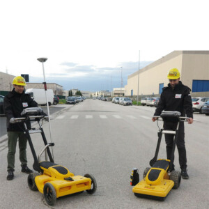
RIS MF Hi-Mod is a robust high performance multi-use ground penetrating radar system capable of scanning large areas in a short period of time and providing an accurate 3D view of the subsoil with a high resolution and depth of penetration. The Hi-Mod provides a complete end-to-end solution from the initial data acquisition in the field to final output production in the form of CAD or GIS maps.
IDS GeoRadar North America
Golden, US
Description
A specialised ground penetrating radar (GPR) system, RIS MF Hi-Mod is capable of investigating large areas, providing a 3D view of the subsoil with a high capability of resolution and penetration depth. RIS MF Hi-Mod features:
- End to end procedure ensuring professional results in mapping underground utilities and anomalies
- Specific software tools for automatic target recognition and transfer to CAD/GIS maps for high productivity
- Highest detection percentage level, combining longitudinal and transversal scans and several frequencies
- Modular array, easy to set up and reconfigure in the field
Thanks to the radar's capacity and the archaeologist's experience, buried underground objects can be detected with a high level of confidence and consequently plan the excavation activities.
RIS MF Hi-Mod offers:
- Consolidated complete procedure from field acquisition to the final output (maps on CAD or GIS);
- Mechanical structure for all urban environments and terrains
- Automatic target recognition, automatic tools help the operator locate pipes and cables
- 2D and 3D tomography: optimised tomography for an immediate visualisation of pipes and cables
- Multi-frequency data fusion: automatic fusion of data from 200 and 600 MHz antennas
- Automatic transfer to CAD/GIS: localized pipes and cables automatically transferred to CAD or GIS maps.
More power with an array of scans
The RIS MF Hi-Mod GPR solution is equipped with an array of multi-frequency antennas. This enables a high resolution survey of shallower depths, using 600 MHz antennas, while guaranteeing a great depth range with the 200 MHz.
Why use an array of Antennas?
- Correlate information coming from several data channels
- Accurately reconstruct the path of underground utilities in complex situations
- Ensure accuracy and productivity.
Other benefits of the RIS MF Hi-Mod GPR solution include:
- All-in-one: Two antennas in the same box, with the option of choosing 200 MHz and 600MHz or 400 MHz and 900MHz, help the operator to locate pipes and cables by providing the proper frequency for a specific search parameter. This provides a real-time display of deep and shallow antennas on the same screen.
- Modular: Antenna boxes can be quickly added in "chain connection" while in the field (no tools required) with up to 8” operation simultaneously. As a result, the system is able to work in any available space.
- 3D Radar Tomography: Multi-frequency data fusion and a consolidated procedure to collect the data enable accurate 3D images of the subsurface to be achieved, helping the operator to distinguish individual anomalies and buried targets.
- Professional utility mapping capability: The result can be exported in several formats including GIS and CAD (AutoCAD or MicroStation) for a professional survey.
- Flexible: Powered by the IDS multi-channel control unit, the system can be used to drive every IDS antenna
Specifications
-
General
-
Application Type
Pipes & Cables
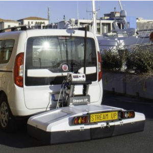
Mounting
Carriage
Total weight full configuration (including batteries, Control unit, datalogger, carrier) {kg}
58
Power type
Number of Channels
8
-
Antennae
-
Type
Antenna Technology
Central Frequency (MHz)
200/600
Max acquisition speed (@ standard scan interval)
4 m/sec
Certificates and Standards
FCC
Bits per Sample
Number of Channels
8
Antenna Coupling
Ground-coupled
-
Control Module
-
Type
-
Datalogger
-
Type
Operating System
Display Type
Data format
-
Positioning
-
Type


