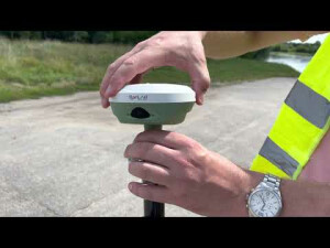
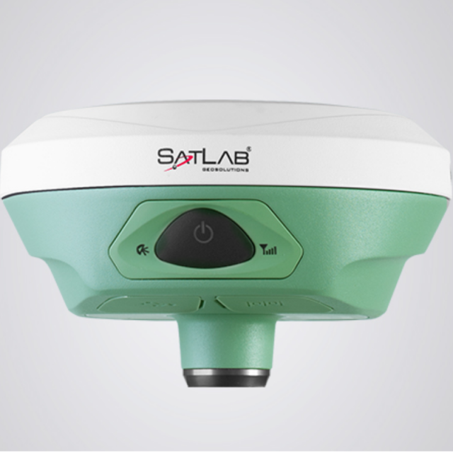
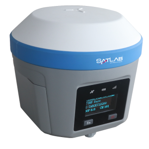
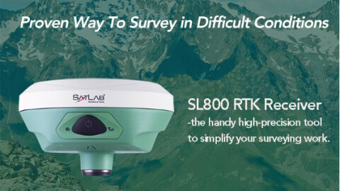
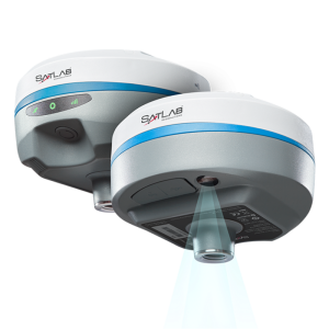
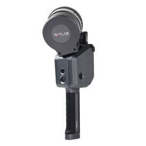
SatLab SL800 GNSS Receiver
Most Agile and Intuitive GNSS RTK Rover
The gnss receiver provides an easy solution for survey professionals who require a portable instrument to collect highly data for various geospatial usage. It allows user flexibility to easily collect data with just one receiver in the field connecting to CORS via any preferred devices to keep you focused and productive.

SatLab
Vastra Frolunda, SE
Description
What is RTK
RTK positioning based on at least two gnss rtk. Powered by the multi-constellation, triple frequency, long-range Bluetooth and Satlab Cloud Services support, this is the most convenient and efficient rtk for today’s network age.
Efficient and dependable
Powered by NovAtel OEM729 GNSS engine, this receiver offers precise positioning and advanced interference mitigation which performs even in the most remote or challenging environments. Using its 555 channel tracking capabilities, it can track all current and upcoming signals, offering sub-metre to centimetre precise positioning.
Satellite correction service
The SL800 has TerraStar capabilities that use a global network of multi-GNSS reference stations and advanced algorithms to generate highly precise GNSS satellite orbit, clock, biases, and other system parameters. These data allow TerraStar to provide correction services with sub-metre or centimetre-level positioning accuracy to receivers. Get your corrections transmitted in real-time, with minimal latency via satellites and cellular networks worldwide.
Applications
Mapping
Land Survey
Topography and As-built
Landfill
Hydrographic
Agriculture
Sensor
UAV Base Station
For more information, please click HERE to visit our website.
Do you have questions about this product?
- Questions about price, availability, and/or retailers
- Questions about technical specifications and usage
- Questions about suitability for your project or application
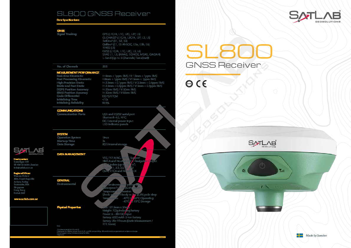
Specifications
-
Power
-
Operating power: min. [V]
6
Operating power: max. [V]
28
Internal power supply
6300 mAh Li-lon Battery
Operating time with internal power supply [hr]
9
Typical consumption [W]
3.2
External power supply
6-28V DC external power input(5-pin port) with over-discharge protection
Certifications
CE
Rechargeable with (auto)battery
Yes
Connectors
RS232, Mini USB
-
Performance
-
No. channels
555
Tracked satellite signals
GPS: L1 C/A, L1C, L2C, L2P, L5 - GLONASS: L1 C/A, L2C, L2P, L3, L5. BEIDOU: B1, B2, B3. GALILEO: E1, E5 AltBOC, E5e, E5b, E6. IRNSS: L5. QZSS: L1 C/A, L1C, L2C, L5, L6.
SBAS differential signals
L1 C/A, (WAAS-EGNOS-MSAS-GAGAN)
Type of measurements
Code and Carrier Phase
RTK Network Compatibility
Yes
MRS functionality
Yes
Max. simultaneous tracked channels
555
-
General
-
Type
Land
Height [m]
0.057
Width [m]
0.1275
Total Weight [kg]
0.7
Housing Material
Magnesium Alloy
-
Horizontal uncertainty
-
phase: RTK kinematic (constant part) [m]
0.008
phase: RTK kinematic (variable part) [ppm]
1
Initialization time on the fly [s]
10
RTK network solution methods
VRS, FKP, MAC, intRTK Support
code: DGNSS/RTC (constant part) [m]
0.25
code: DGNSS/RTC (variable part) [ppm]
1
phase: RTK rapid static (constant part) [m]
0.0025
phase: RTK rapid static (variable part) [ppm]
0.5
-
Communication: Protocols
-
RTCM standards for differential data
2.1, 2.3, 3.0, 3.1, 3.2
CMR standards for differential data
CMR, CMR+
Other formats for differential data
RTCA and NOVATELX
NMEA output format
NMEA and Novatel ASCII Navigation Output
L-Band Compatible
L-Band: Up to 5 channels
-
Recording
-
Data capacity [MB]
8192
Type of data (on board recording)
NMEA and Novatel ASCII Navigation Output
Memory medium
Internal storage
Data input
RTCM, CMR, RTCA and NOVATELX
-
Communication: general
-
Communication ports
RS232 Serial Port, USB, NFC, Bluetooth 4.0
Bluetooth
Y
-
Environment
-
Operating temperature: min. [°C]
-40
Operating temperature: max. [°C]
65
Humidity resistance
95%, condensing
Water sand and dust proof
IP67 Environmental Protection, Waterproof to 2m Depth
Shock and vibration proof
Shock Resistant Body to 2m Pole Drop
Documents
Brochure
sl800-gnss-receiver-brochure-en-20190517x.pdf
1.06 MB

