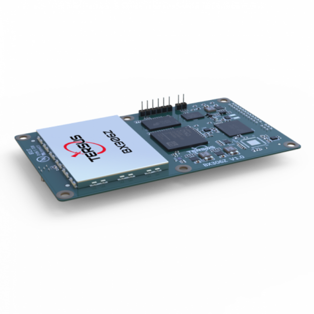
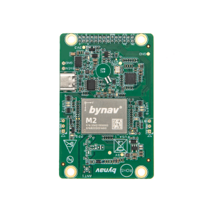
GNSS RTK Board BX306Z (GPS L1L2+GLONASS L1L2+BeiDou B1B2)
Tersus GNSS
Shanghai, CN
Description
BX306Z is a GNSS RTK board for accurate position. This board offers cm-level positioning capability and integrates with inertial navigation unit. The board uses standard serial ports for communication. A specified connector makes it easy to integrate to its host devices or autopilots. BX306Z board supports multi-GNSS RTK positioning, which improves the continuity and reliability in challenging environment. The flexible interfaces, hardware size and the main commands make it compatible with GNSS boards in the market.
Specifications
-
More information
-
Distinguishable features
Support camera shutter synchronization; Raw observation data logging supported
-
Power
-
Operating power: min. [V]
3.3
Operating power: max. [V]
3.3
Typical consumption [W]
2.9
Internal power supply
NA
External power supply
NA
Operating time with internal power supply [hr]
0
Certifications
NA
Rechargeable with (auto)battery
NA
Direct car connection cable available
NA
-
Performance
-
Max. simultaneous tracked channels
192
Tracked satellite signals
GPS L1/L2, GLONASS G1/G2, BDS B1/B2
SBAS differential signals
NA
Type of measurements
Carrier phase; C/A code; P code
Reacqisition time [s]
1
RTK Network Compatibility
Y
MRS functionality
N
No. channels
192
-
General
-
Year of initial introduction
2017
Height [m]
0.1
Depth [m]
0.06
Width [m]
0.012
Total Weight [kg]
0.044
Housing Material
Aluminum
Type
Aerial, Land, Marine
-
Horizontal uncertainty
-
code: DGNSS/RTC (constant part) [m]
0.3
code: DGNSS/RTC (variable part) [ppm]
1
phase: RTK rapid static (constant part) [m]
0.003
phase: RTK rapid static (variable part) [ppm]
1
phase: RTK kinematic (constant part) [m]
0.01
phase: RTK kinematic (variable part) [ppm]
1
phase: static post processing (constant part) [m]
0.01
phase: static post processing (variable part) [ppm]
1
phase: kinematic post processing (constant part) [m]
0.01
phase: kinematic post processing (variable part) [ppm]
1
Initialization time on the fly [s]
10
Range on the fly [km]
20000
RTK network solution methods
RTCM; CMR; CMR+
-
Communication: Protocols
-
RTCM standards for differential data
RTCM 2.x/3.x
CMR standards for differential data
CMR; CMR+
Other formats for differential data
NA
NMEA output format
NMEA0183
other output formats
Tersus binary
L-Band Compatible
NA
Configuration method
Commands/PC software
-
Recording
-
Memory medium
NA
Data capacity [MB]
0
Type of data (on board recording)
Binary; NMEA
Data input
NA
-
Communication: general
-
Communication ports
Serial (LVTTL*1, RS232*1) port; USB port; Ethernet
Simultaneous links
N
PPS Out
Y
Bluetooth
N
-
Environment
-
Operating temperature: min. [°C]
-40
Operating temperature: max. [°C]
85
Humidity resistance
95%
Water sand and dust proof
NA
Shock and vibration proof
NA
ROHS compliance
N
WEEE compliance
N
-
Communication: links
-
Radio modems
NA
GSM; UMTS phone modems
NA
CDMA phone modems
NA
Landline modems
NA
Videos


