imajview
GIS data production and photogrammetry
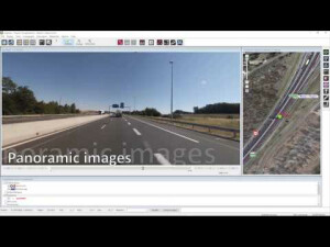
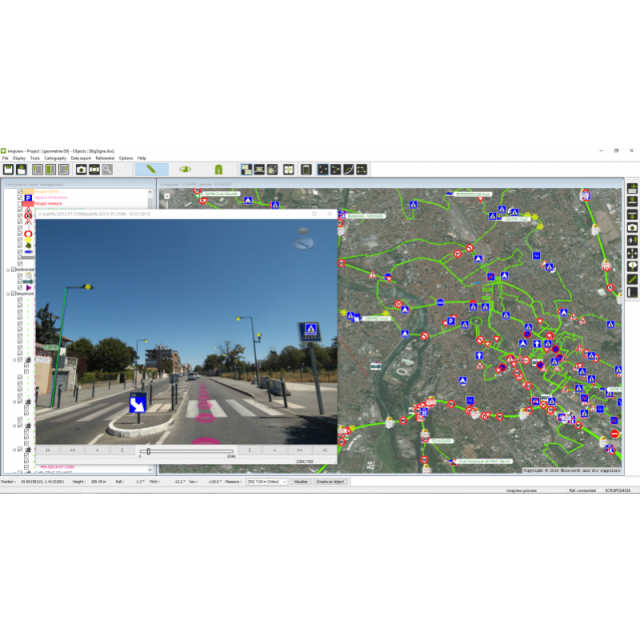
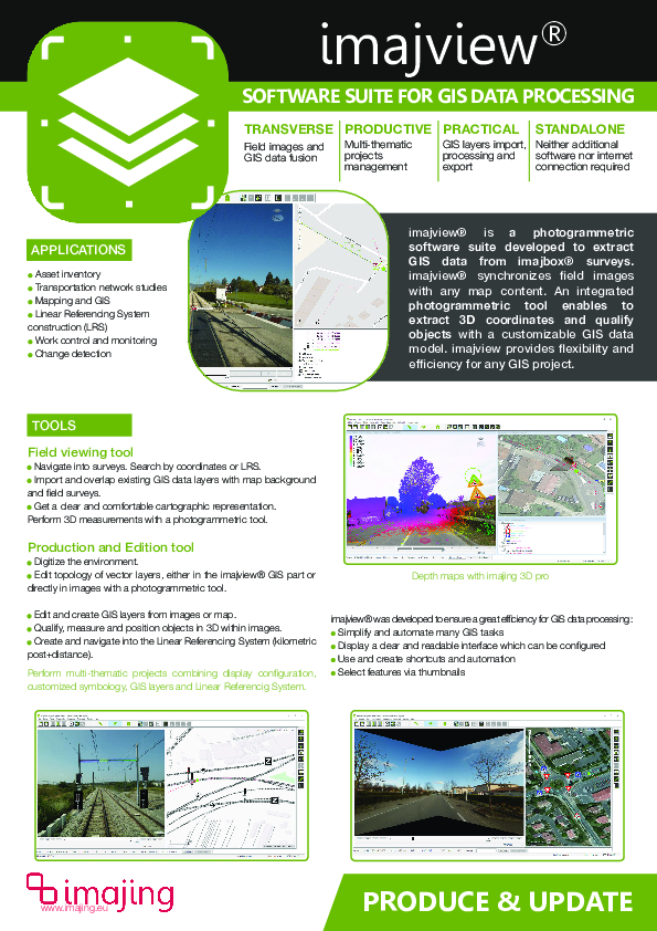
imajview is a photogrammetric software suite developed to extract GIS data from imajbox surveys. imajview synchronizes field images with any map content. An integrated photogrammetric tool enables it to extract 3D coordinates and qualify objects with a customizable GIS data model. imajview provides flexibility and efficiency for any GIS project.

imajing
Labège, FR
Description
imajview is a photogrammetric and GIS software suite for GIS data production and edition. imajview enables to process imajbox data and to geo-reference with attributes all features visible in images. The GIS data model is customizable and adaptable to any asset management project. imajview fully synchronizes imajbox data with any map content, enabling virtual navigation and GIS data production & edition. Any data layer created in imajview can be exported in various formats such as shape, KML and CSV. imajview can be used for various applications : asset inventory, transportation network studies, mapping, linear refencing system management, work control and monitoring, change detection.
Do you have questions about this product?
- Questions about price, availability, and/or retailers
- Questions about technical specifications and usage
- Questions about suitability for your project or application
Specifications
-
Data management
-
Security options for access
N
Search on file content
N
Version management
Y
Spatial reference system
Fixed
-
Geometry types
-
Lines
Line segment, Polyline
Points
Point
Surfaces
Polygon
Raster
Reference
-
Other
-
License or freeware
License
Training
Y
Main users
GIS users in roadways, railways, utilities and waterways assets mangement.
Main applications
Transportation network's asset inventory for GIS.Based on a photogrammetric tool :- 3D object layers creation and edition with attributes (GIS layers)- Points, lines and polygones creation- Objects referencing in geographical coordinates (xyz) and linear coordinates (km+distance)- 3D Measurements in images- Rectified ground-orthophoto projection.
Related products
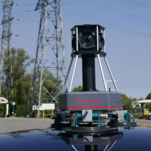
imajbox, compact mobile mapping systemimajnet, web service
Distinguishable features
User friendly.Imports external data (shapes, dxf, kml, geodatabase, osm, tab, geo-tiff, ecw)Connect to WMS clientManages multi-thematic projects.Synchronizes field images and GIS layers.Adapted and optimized for imajbox surveys.Enables 3D measurements in images.Enables to customize GIS data modelExports data into shapes, csv, kml, jpg
Extensions
imajview Nav - Data viewing // imajview Process - GIS layers editing // imajview 3D - 3D processing
-
2D Editing
-
Select
By drawing attributes, Spatial selection, Others
Remove
Graphic transformations
Move, Others
Coordinate transformations
Y
Mosaicing
N
Generalization
N/A
-
2D Construction
-
Positioning by coördinates
Y
Positioning in relation to other element
Parallel, Perpendicular
Positioning by snapping
Y
-
Storage
-
Type of data storage
File, Database, Private cloud
Native storage format
xml
Input formats
Dwg, Dxf, Shape, KML, GeoTiff, ECW, Jpg, Others
Export formats
Shape, KML, Jpg, Others
GML version
N/A
Compression
N
-
Visualisation
-
Types
Color, Pattern, Hatch, Gradient color
Change view
Temporal
Y
Thematic mapping
-
Interoperability
-
Web standards
WMS
Spatial database management systems
PostGIS
Messaging protocols
None
Publish standards
None
Extensions
none
Available API’s
N/A
Metadata
None
-
General
-
Year of introduction
2011
Year of last update
2019
Supported hardware
imajbox mobile mapping system
Supported operation system
Windows
Main GIS category
Desktop GIS
-
Data analysis
-
Clip
N
Merge
Buffer
Overlay operations
Documents
Brochure
migrationax8nxi.pdf
2.07 MB
Other documents
-
Brochure395.01 KB


