
Allvision Urban Mobility Solutions
Enabling Optimization of Shared Use Spaces
Utilizing data generated from autonomous vehicles, mobile survey platforms, and satellite/aerial imagery, Allvision is able to create and maintain rich geo-spatial models of key infrastructure and environments across a variety of domains. Whether you’re looking to improve vehicle turnover in high traffic commercial zones, monitor vegetation encroachment on power lines, or service and maintain assets inventories, Allvision can help.
Description
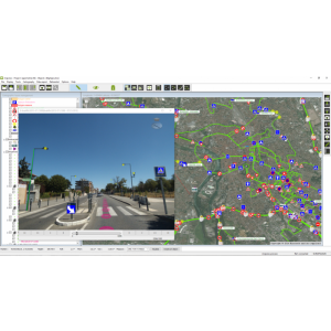
Allvision is able to provide the high definition map (we collect the data using state-of-the art sensors, or the data can be provided to us) that give insights into parking utilization over a specific timeframe. For example, where signage is located and what condition is it in, how many infractions occur in specific areas in a given period of time and by whom (delivery truck, personal vehicle, motorcycle, etc.).
We can also help determine what areas are ADA accessibility compliant and which fall short, helping to future-proof citiscapes. Prior to the era of digital data collection, signs and other assets were collected by feet-on-the-street, or people with clipboards manually noting the information. The benefit of a vehicle-based sensor approach is clear — it is fast, scalable, and can be deployed city-wide and beyond.
Specifications
-
Data management
-
Spatial reference system
-
Geometry types
-
Lines
Points
Surfaces
Raster
-
Other
-
License or freeware
-
2D Editing
-
Select
Remove
Graphic transformations
-
2D Construction
-
Positioning in relation to other element
-
Storage
-
Type of data storage
Input formats
Export formats
-
Visualisation
-
Types
Change view
Thematic mapping
-
Interoperability
-
Web standards
Spatial database management systems
Messaging protocols
Extensions
Metadata
-
General
-
Supported operation system
Main GIS category
-
Data analysis
-
Merge
Buffer
Overlay operations
