Virtually Performed Inspection of a Subterranean Tunnel Using 3D Laser Scanners and Lidar Software
The Laramie-Poudre Tunnel is an early transmountain tunnel in the state of Colorado. The tunnel's primary purpose is to transfer water from the west side of the Laramie River basin to the east side Cache la Poudre River basin. The tunnel stretches approximately 12,000 feet (3,600 m), and has an average diameter of 5.3 feet (1.6 m). Using existing data collected using a Leica Pegasus Backpack, Tukuh Technologies, a Kansas City based company, embarked on a project to provide a virtual model of the tunnel to their client. With nearly 270 GB of data, they needed a solution that could manage the data and allow nontechnical stakeholders to view, measure, and inspect the tunnel from their computers.
Virtually Performed Inspection of a Subterranean Tunnel Using 3D Laser Scanners and Lidar Software
Laramie-Poudre Tunnel mobile scanning data visualized in SOLV3D encompass 3D Mode.
Solution
After reviewing many of the available technologies, Patrick Crawford, Reality Capture & Information Modeling Specialist at Tukuh, decided on the SOLV3D encompass (Encompass) solution.
"With Encompass, we were able to show the client how they could virtually locate, inspect and tag areas of interest. The fact that large amounts of geospatial data can be accessed through any connected device by non-technical stakeholders was a huge selling point. The integration of Encompass with our existing AutoCAD and ArcGIS Online solutions make it an extremely powerful tool." said Crawford.
"The fact that large amounts of geospatial data can be accessed by any connected device by non-technical stakeholders was a huge selling point."
Virtual inspection using high-density LiDAR and imagery data eliminated the risks related to health and safety for team members while providing a baseline data set for future scan work to be compared for change detection. Using the annotation and markup tools within Encompass allowed team members to geographically pinpoint locations of question or concern and share those locations with others. Team members were also able to attach documents and images to these tagged locations.
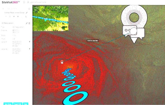
Annotation pin is shown in SOLV3D encompass.
Through Encompass the team will have the ability to track maintenance schedules, perform inspections and manage the tunnel for years to come while ensuring the safety of their team.
SOLV3D engine™ Classifies LiDAR Data from Old Smokey River Scan
The Smoky Hill River is a 925 km (575-mile) river in the central Great Plains of the United States of America. It runs from the state of Colorado into Kansas where it joins several rivers to become the Kansas River. Tukuh Technologies, a Kansas City based company employed a Mobile LiDAR collection method to collect a 11.3 km (7-mile) long run of dry river bed. The resulting data was used as an accurate ground surface model for hydrology studies with the intent of
improving the river channel and increasing water flow.
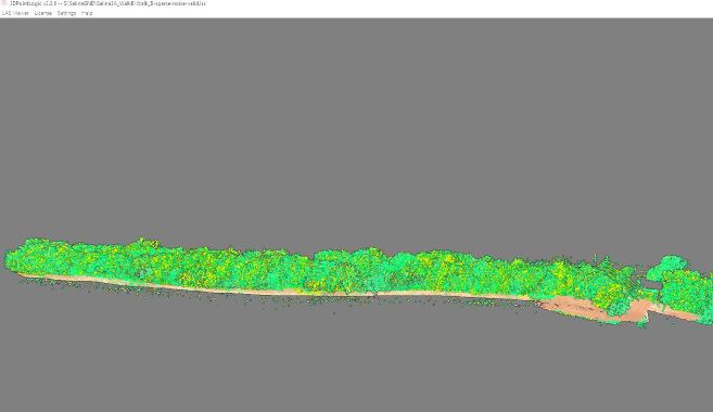
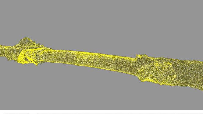
Vegetated profile of Old Smoky River near Salina Kansas as viewed in SOLV3D's LAS Viewer.
Terry Pallotto, Head of Technology Innovation at Tukuh remarked "SOLV3D engine's strong classification tools; and its ability to link them together, allowed us to quickly classify the nearly 2 TB of LiDAR data. We ran the classification tools several times, adjusting the settings to eliminate noise and classify the LiDAR."
"SOLV3D engine's strong classification tools; and its ability to link them together, allowed us to quickly classify the nearly 2 TB of LiDAR data."
Tukuh Technologies, about
Tukuh Technologies, LLC, is a tribally-owned 8(a) technology company that develops innovative solutions tailored to their clients' specific needs. They deliver a full range of geospatial, managed IT and staff augmentation services to federal, state, municipal and commercial clients across the country faster and more cost-effectively than ever before. They bring an extraordinary depth of knowledge and expertise to each project, allowing for targeted solutions that meet and exceed today's evolving requirements.
About SOLV3D
SOLV3D is the creator of innovative software solutions for geospatial data processing, visualization and collaboration. The SOLV3D engine™ processing toolkit assists users in optimizing point cloud data for effective use within their applications and workflows. SOLV3D encompass™ provides the ability tomerge together amyriad of geospatial datasets in a single platform. Within a web-based environment, it enables all stakeholders to easily gain situational awareness and work together on projects, AOIs and assets, regardless of geographical location or level of expertise.
Do you have questions about this case study?
Get in touch with SOLV3D Inc., and they would be happy to answer any questions you have about pricing, suitability, availability, specs, etc.


