

Using 3D Laser Scanners for Future Smart Cities
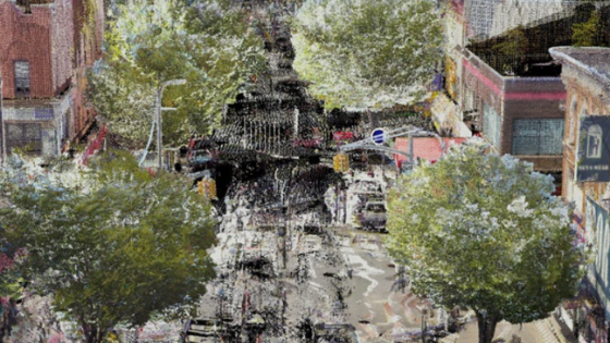
As part of a pilot program to prove the applicability of laser scanned data in a Smart Cities project, Wales-based Gwalia Surveyors, recently took to the streets of the Brownsville section of Brooklyn, New York. There, using a Topcon GLS-2000 laser scanner, they scanned a segment of the district in the hopes of using that data to create an information-rich, geometrically accurate, interactive BIM model. The model, when further developed, could provide valuable information useful for the implementation of the new technology that is so key to the Smart Cities concept.
Using 3D Laser Scanners for Future Smart Cities
"We set out to laser scan just a small fragment of the Brownsville section of Brooklyn, then tag and schedule info for subsequent use in determining what is important in this space..." - Llyr Lane, Gwalia Surveyors
Use of experience
The idea of smart cities, metropolitan areas in which information and communication technology (ICT) and Internet of things (IoT) technology are securely integrated in order to manage a city's myriad physical and informational assets, dates back more than a decade. As the concept has grown, however, so too have the programs put in place to aid in its development. According to Gwalia’s Llyr Lane, his company’s interest stems from its own proven expertise in BIM technology.
“We’ve been laser scanning for about six or seven years now,” he said. “We got into it fairly early and always felt like there was going to be a time when 3D modeling and point clouds were going to be the order of the day. Largely because of the British government’s 2016 mandate that any government-funded project must be conducted at a BIM Level 2, that’s come true. For us, performing building work, a refurbishment for example, regularly includes laser scanning to a point cloud, modeling, then tagging and scheduling all the elements in the structure.”
Taking it to the streets
If BIM could prove so invaluable inside a structure, thought Lane and his team, why couldn’t that applicability extend beyond the structures to the open spaces outside of these buildings? Based on what they already knew, they felt that the potential for a geospatial solution, specifically a laser scanner, was limitless.
“We knew that the strengths of this technology were perfect for what the Smart Cities concept represents,” Llyr said. “The focus from the NYC perspective was on improving health and safety, improving security, providing connectivity for all, integrating both existing and evolving technology and job creation. With those criteria in mind, we set out to laser scan just a small fragment of the Brownsville section of Brooklyn, then tag and schedule info for subsequent use in determining what is important in this space, what will affect the quality of life for those in that area, etc.”
Some of the tech approaches being considered for the target section of Brooklyn included benches that use solar power to provide a mobile device charging station, and Bluetooth beacons designed to help visually impaired people. In the first example, obviously, benches that utilize solar conductivity need to be placed in areas that make use of maximum sunlight. So heights of buildings, their position relative to the sun at different times of the day, etc., become critical.
“In the case of the Bluetooth beacons, it is envisioned that a person could, for example, have their phone notify them that there is a bus stop 300 meters down the road,” added Lane. “Using the data derived from our laser scanning session, we can provide dimensionally correct information that will help make that possible. And, because we can offer millimeter-grade accuracies, they can set the beacons precisely where they are needed along a route, knowing they have dimensionally-correct info as that notification is issued.”
"We can tag assets such as lampposts, street signs, traffic signals, etc., with specifics such as material of construction, location, height off the ground — essentially providing a DNA of the space" - Senior land surveyor for Gwalia, Duncan Bell
After acquiring the data
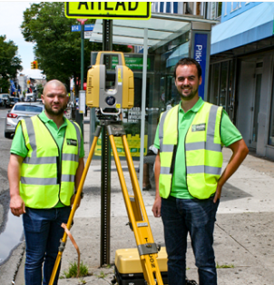
The pilot scanning session conducted by Gwalia covered a roughly six-block area in Brownsville. Equipped with the Topcon GLS-2000 laser scanner, Lane and Duncan Bell, a colleague and senior land surveyor for the company, set up at various points and conducted more than two-dozen individual scans that would be used to create the 3D model of Brownsville. Taking the data back to the U.K., Lane utilized Topcon MAGNET Collage software to begin construction of the point cloud. Topcon MAGNET Collage software delivers processing and mass data handling at previously unmatched speeds, often as much as eight times faster, with a comparably quick rendering and visualization capability.
“Using Collage, the registration process was extremely quick,” said Bell. “In addition, the graphics engine is much smoother, thereby enabling the viewing of larger data sets. It is also ideal for generating a web-based platform accessible by members of the public, precisely our long-term goal for the smart cities project.”
With the point cloud data in hand, using Autodesk Revit, Duncan created a 3D model of the target Brownsville section, then conducted several model “fly-throughs” before beginning the actual tagging and scheduling effort. “We can tag assets such as lampposts, street signs, traffic signals, etc., with specifics such as the material of construction, location, height off the ground, essentially providing a DNA of the space,” he said.
For the betterment of life
What Lane and the Gwalia team hope to accomplish as a result of their initial scanning session in Brownsville, is the creation of a dimensionally correct platform which will be useable both by each partner involved in the project and, eventually, by the general public. The resultant model will be scalable to the entire NYC metropolitan area and will be rich in elements that are tagged and scheduled.
“Most non-survey people don’t realize the many ways that a GLS-2000, in the right hands, can be valuable; this is a huge step toward opening some eyes.”
In the course of conducting the scanning for the pilot project, Lane and Bell became aware of many other areas in which the technology could prove invaluable. Of particular note during their visit to the Brownsville area was the relatively poor condition of the roads and sidewalks. Without knowing it, they had arrived at the metaphorical place that Topcon calls the “Intersection of Infrastructure and Technology”, the point at which construction productivity can be improved by applying advanced positioning technology. Lane cited a recent project they did as offering similarities in the solution that could be applied to address the road issue.
“We recently did some work for British cycling in an outdoor velodrome in which we scanned the course and created a mesh in the software, then went back three months later and re-scanned the same area,” said Lane. “By overlaying the two meshes and using a color-based indicator to show changes, we were able to immediately spotlight any deviation that had occurred. That same approach could easily be used to deal with area roads and sidewalks.”
Trash solutions
Lane said that, when he attended the Smart Cities conference, he heard from a Brooklyn woman who spoke about problems they were having with trash collection. She was wanting to get more information on how any of this technology might apply to that situation. Her question, of course, got Lane’s creative juices flowing.
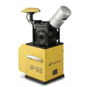
“We could drive an area with a Topcon IP-S3 mobile scanner, then tag and schedule all the bags of rubbish that we scanned,” he said. “Out of the ordinary? Sure, but a car driving the streets of New York scanning bags of rubbish and subsequently tagging them in the data, could be the makings of a valuable database to the right customer.”
And it wouldn’t raise an eyebrow with the locals.
Do you have questions about this case study?
Get in touch with Topcon, and they would be happy to answer any questions you have about pricing, suitability, availability, specs, etc.


