


Using Radar Data to Anticipate Ice Avalanches
The risk of natural hazards and the associated damage are globally on the rise. Extensive protection structures are costly and may not prevent damage by themselves. Spatial planning and preventative measures have become the most important actions for successful civil and assets protection. A permanent monitoring of the specific hazard processes allows for early detection of imminent risk or the continuous modification of the hazard situation. The potential damage caused by an event can be remarkably reduced with warning and alarm systems, if set up and used correctly.
The Swiss-based technology company Geopraevent is an expert in this field. Geopraevent develops, installs and operates customised alarm and monitoring systems for various natural hazards, such as avalanches (snow and ice), rockfall, debris flows or floods. The applied technologies include different types of radar, e.g. the interferometric radar supplied by Italy-based leading provider of Ground Penetrating Radar and interferometric technology solutions IDS GeoRadar. Geopraevent currently runs more than 60 systems globally, many of them in high mountain environments. Recently, one of them clearly demonstrated the ability to predict an imminent event and react early: the failure of the Trift Glacier on Weissmies situated above the village of Saas Grund in Switzerland’s region of Wallis.
Monitoring in an Alpine Environment Can Be a Challenging Task
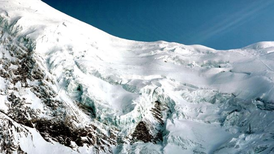
The well-known summits of Fletschhorn (3993 metres), Lagginhorn (4010 m) and Weissmies (4017 m) separate the Saas-Valley from the Simplon Valley in southern Switzerland. Easily accessible from the cable car station located at Hohsaas, in Canton of Wallis, the Weissmies is one of the most frequently climbed peaks in the area.
In summer 2014, the Trift Glacier, located on the north-west face of Weissmies, showed increased ice avalanche activity. The hanging glacier, formerly supported by ice from below, had destabilised due to glacier mass loss predominating in steeper areas. Canton of Wallis authorities approached Geopraevent with the request to monitor the glacier movement to enable early actions in case of possible ice failures resulting in a large ice/snow avalanche. The specialised engineers of Geopraevent visited the measurement site immediately and supplied the local decision-makers and responsible authorities with glacier velocity data on the evening of the day of installation.
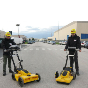
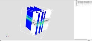
Interferometric radar data integrated into geotechnical analysis provides the detailed information required to the experts judging the situation. Interferometric radar is a reliable technique for short or long-term monitoring of multiple scales of displacements regardless of visibility and weather conditions. The radar measures spatially resolved deformation rates with high accuracy. IDS GeoRadar IBIS FM radar is the system delivering reliable and accurate data of displacements in real-time despite the atmospheric correction needed in high altitudes. In addition, a high-definition camera was installed at this location and proved to be an excellent alternative for automatic long-term deformation analysis if the weather is not an issue.
Monitoring Critical Landslides and Ice Avalanches
Despite the turbulent atmosphere over the glacier that can hamper the measurements at times, reliable measurements have so far been obtained daily. To account for the highly variable alpine conditions, Geopraevent added an extra processing step that verified the plausibility of the data before making it available to the customer via its online data portal. This provided sufficient data for VAW/ETH Professor’s Martin Funk group and the local geoformer GmbH’s engineers to interpret the prevailing hazard for the area below the hanging glacier.
“After almost three years of continuous radar monitoring, statistics showed that the radar delivered viable deformation data on 95 per cent of days. Radar measurements only failed temporarily during heavy snowstorm due to surface changes caused by snow and rain,” said Richard Steinacher, physicist and project leader at Geopraevent.
Compared to the rest of the glacier moving at about 10 centimetres per day, the unstable part initially moved at a significantly higher velocity of approximately 25 cm per day. Between 2014 and 2017, dozens of small and harmless ice avalanches could be predicted from the radar data usually a few days in advance.
Forecasting the Inevitable Saves Lives
After 2.5 years of successful operation, the interferometric radar was replaced by a high-resolution camera in early 2017 for visual deformation analysis. This camera delivered excellent results that tracked the movements of the glacier daily if visibility conditions permitted. The camera analysis revealed a distinct acceleration of the glacier starting around August 20th. At the beginning of September, it was clear that the glacier would fail soon.
To provide velocity data also during the night and bad weather, Geopraevent re-installed the interferometric radar on September 7th. Velocities were on the order of 80 cm per day and accelerated to more than 2 m per day on Saturday, September 9th. Breakoff-predictions on that day suggested that an ice volume of up to 400’000 m3 would fail in the early morning of Sunday, September 10th. Consequently, 220 inhabitants of the endangered village part of Saas Grund were evacuated. Most of the unstable ice volume collapsed, as predicted, around Sunday, 6 a.m. Fortunately, the ice detached in several small portions within ten minutes as revealed by the radar interferograms. No damage occurred and by 8 a.m. all inhabitants could return to their homes.
Safety Monitoring and Long-term Planning in Real-time
IDS GeoRadar IBIS-FM system collects quantitative information on slope behaviour from either a spatial or a temporal point of view. It provides reliable early-detection alerts on impending failures in real-time, as well as accurate geo-referenced outputs over long periods of time allowing users to integrate radar data into a geotechnical analysis of slope failure mechanisms.
“The IBIS-FM radar accurately monitors multiple scales of displacements in real-time, from early detection of slow movements to fast accelerations associated with slope collapse. The great operative range, up to 4500 metres allows to safely deploy the system in comfortably accessible areas without exposing people and equipment to hazardous zones,” said Paolo Papeschi, IDS GeoRadar GEO business unit manager. “Thanks to the most advanced automatic algorithms in the market, IBIS-FM delivers reliable and accurate data in all weather conditions. Monitoring experts can respond to slope hazards faster ensuring the safety of operators and the public.”
Geopraevent also installed an IDS GeoRadar system above Bondo in the region of Bergell, in Canton of Graubunden, Switzerland, after a massive landslide occurred in August 2017. The radar, installed on 3 September 2017, monitors the Pizzo Cengalo permanently and detects millimetre-movements in all weather conditions. The radar allows to predict new rockfalls early and initiate appropriate measures; a rockfall event on 15 September 2017 was predicted about one day in advance.


