Using Mobile Mapping and Airborne Lidar Scanning to Create Digital Twins
Traditional methods of collecting and representing 2D spatial data, such as maps and images, are no longer sufficient, and a complete upgrade of traditional survey tools is required to move to 3D modeling. Derived 3D models indeed have a great capacity to be merged and correlated with social or economic spatial data from IoT and Big Data. Today, a very strong demand exists for integrated solutions, allowing the capture of comprehensive 3D geospatial data, with high accuracy and in a short time frame.
Creating 3D Models For Digital Twin Projects
Since its emergence more than a decade ago, digital twin technology has developed into a complex and comprehensive technical system that supports the construction of new smart cities. It is also an advanced model for the continuous innovation of smart urban development and a future form of modernization of the combined "virtual and real" world.
The creation of the digital twin city leverages high-level topographic tools capable of providing comprehensive, multi-dimensional, large-scale, high-resolution data sets. As a virtual model, a digital city provides layered data about buildings, urban infrastructure, utilities, businesses, and the movement of people and vehicles. By providing this information, digital twins enable smart city development and modernization.
Traditional methods of collecting and representing 2D spatial data, such as maps and images, are no longer sufficient, and a complete upgrade of traditional survey tools is required to move to 3D modelling. Derived 3D models indeed have a great capacity to be merged and correlated with social or economic spatial data from IoT and Big Data. Today, a very strong demand exists for integrated solutions, allowing the capture of comprehensive 3D geospatial data, with high accuracy and in a short time frame.
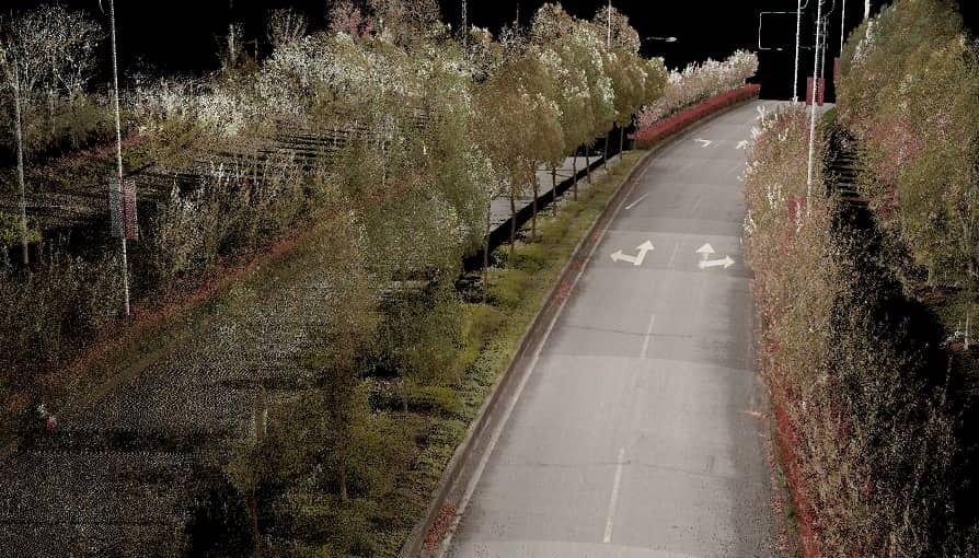
Figure 1. City inspection project, data captured by AlphaUni
Gathering 3D Point Clouds in Cities
To illustrate a typical digital city project, CHC Navigation conducted a proof-of-concept demonstration in the Jinshan District of Shanghai, China. The total area of Jinshan District is about 600 km2. This area has rich terrain characteristics and features typical of large modern cities, such as high-rise buildings, power lines, rivers and vegetation.
Capturing 3D geospatial data from a single platform Lidar system can leave some areas blank in the point cloud data. The AlphaUni 900 Lidar solution, with its multi-platform capability, can easily capture complete data from a drone, car, backpack or boat, and can produce a sophisticated 3D image. The AlphaUni 900 Lidar system seamlessly integrates real buildings, provides outdoor mapping, and dramatically changes the way high-precision 3D data is collected.
Solving the Challenges of 3D Laser Scanning in Urban Environments
1. Using a Terrestrial Lidar on a Mobile Platform
The Alpha3D provides geospatial professionals with a high-performance, vehicle-independent mobile mapping solution for capturing 3D mass data in ever-changing urban environments. Whatever the application, the Alpha3D mobile mapping system dramatically increases the return on investment by getting the work done faster and more accurately. The Alpha3D combines an accurate, long-range, ultra-high-speed laser scanner, a high-resolution HDR panoramic camera, an advanced GNSS receiver, and a high-accuracy IMU, all in a lightweight, compact yet rugged design. All these features make the Alpha3D one of the most innovative mobile mapping systems on the market today.
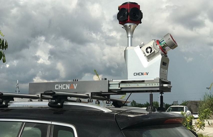
Figure 2. Alpha 3D with Alpha Uni 900 installed on the car for the city inspection.
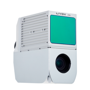
The AlphaUni 900 is a high-end, multi-platform Lidar system that has been designed and enhanced by CHCNAV with many years of experience in 3D data acquisition. The AlphaUni 900 is a fully integrated system with high precision, long-range laser scanners featuring RIEGL's unique Waveform-Lidar technology and high accuracy inertial navigation system, ready for survey missions requiring the highest quality data in the air and on the ground. Its unique design allows it to be mounted on a backpack for narrow street scanning.
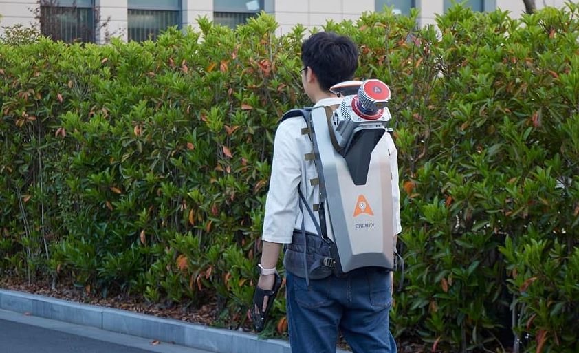
Figure 3. AlphaUni 900 on a backpack for the narrow street survey.
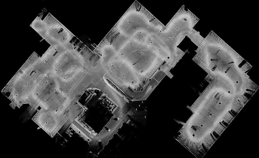
Figure 4. Point cloud from Alpha Uni backpack set-up.
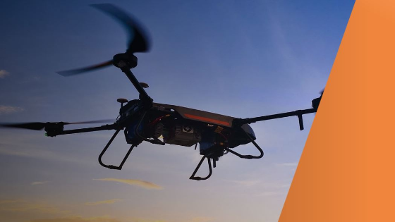
2. 3D Lidar Scanning in Tough to Reach Areas Using a Manned or Unmanned Aerial Vehicle
The limitation of capturing data with a single-platform Lidar system may leave some areas blank in the point-cloud data. Mounted on an airborne drone, the AlphaUni 900 can capture complete data from an aerial perspective.
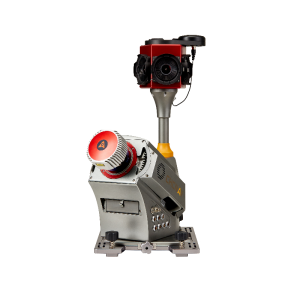
The BB4 UAV is a high-end unmanned aircraft platform resulting from an alliance between two industry leaders in their respective segments. Its scientific design and highly integrated production technology come from CHCNAV, a global manufacturer of efficient geospatial measurement technologies - and its fully automated flight control system from DJI, the pioneer in commercial drone manufacturing.
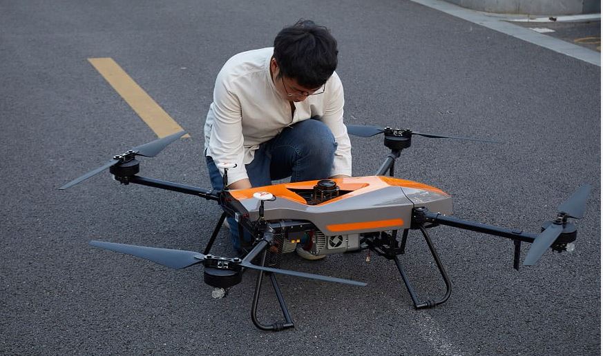
Figure 5. BB4 UAV platform combined with Alpha Uni 900.
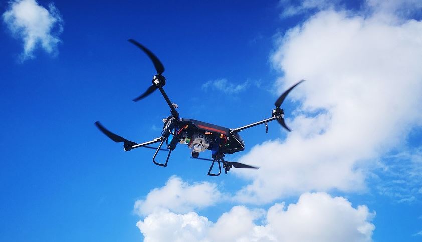
Figure 6. BB4 UAV platform with Alpha Uni 900 can fly for over 40 minutes.
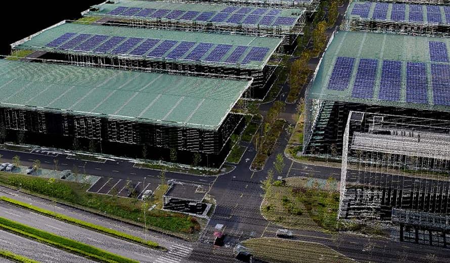
Figure 7. Aerial platform scanning data captured by AlphaUni.
Finalizing the 3D Model By Combining Lidar and Bathymetric Data
The APACHE 6 USV is an integrated innovative solution able to combine high-resolution 3D bathymetric surveys and simultaneously acquire scanning data of the riverbank. Equipped with a Norbit Multibeam Echosounder and the AlphaUni 900, the APACHE6 scans a city's rivers, canals and harbours in a single pass, providing high data consistency and considerable time savings.
Powered by a high-performance dual-propeller system providing a stable automatic cruise speed of up to 2.5 m/s, the APACHE6 USV improves work efficiency and produces high-resolution data to consistently meet the requirements of the most demanding 3D city model projects.
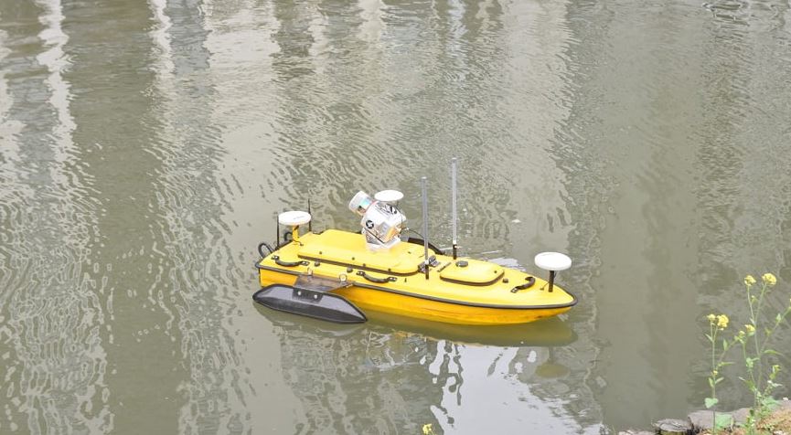
Figure 8. Apache6 USV combined with AlphaUni.
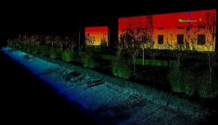
Figure 9. Apache6 USV point cloud from the water channel.
Multi-Platform Accuracy of 3D Lidar Surveying
Final data accuracy after point cloud data integration from multiple platforms:
|
No. |
Surveying Platform |
Integrated 3D point cloud absolute accuracy (RMS) |
|
1 |
UAV/drone |
30 mm |
|
2 |
Car |
25 mm |
|
3 |
Boat |
70 mm |
|
4 |
Backpack |
50 mm |
All data can be published together on an internet cloud service using the CHCNAV Orbit publisher.
Conclusion
During the project, the CHCNAV AlphaUni 900 seamlessly integrated city buildings into the datasets and provided sophisticated 3D images and point clouds from aerial, terrestrial and water environments. The extensive coverage of the derived 3D models has a high capacity to be merged and correlated with social, economic and infrastructure spatial data.
CHCNAV's AlphaUni 900's high accuracy capability and cross-platform design successfully provide an innovative solution to the 3D geospatial data acquisition problems required for smart city development.
The AlphaUni 900 Lidar system innovates the way we do mapping.
Whatever the application, CHCNAV’s solutions for mobile mapping can significantly increase your return-on-investment by completing work quicker and more accurately.
Do you have questions about this case study?
Get in touch with CHC Navigation | CHCNAV, and they would be happy to answer any questions you have about pricing, suitability, availability, specs, etc.
Related articles


