UAV LIDAR/Imagery Sensor in Rapid Response
GeoCue has been recently involved in two separate operations where rapid “flight to data” was a requirement. Customers are more and more realizing the advantages of quick processing as well.
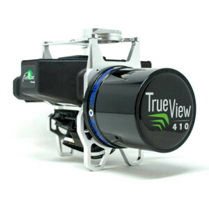
What is GeoCue's True View 410?
GeoCue’s UAV Lidar Imagery sensor, True View 410, is a 3D Imaging Sensor (3DIS) with bundled drone mapping processing software. 3DIS is a combination of both a sensor for creating a direct 3D point cloud as well as a sensor used to “colourize” the points. In the case of our UAV LIDAR/Imagery sensor, True View 410, the point cloud generator is a Quanergy M8 Ultra laser scanner and the colourization sensors are a pair of 20-megapixel (MP) photogrammetric GeoCue Mapping Cameras. The complete drone mapping software, True View Evo, needed to process the data from raw collection to analytic products (visualization, classified ground, DEM, contours and so forth) is bundled with the True View 410 system.
I am a big fan of point clouds from imagery (“photogrammetric” point clouds) as obtained from applications such as Pix4D and Metashape. We have been building support tools for these applications for years. However, (and this is the motivator for LIDAR, of course) this technique only works on non-vegetated surfaces and the data can take quite some time to process. For example, processing 1,000 images from a 20 MP camera might take up to 6 hours of computing time, even on a fairly robust computer. Processing a True View 410 flight of equivalent size (about 17 minutes of flight time) to the same point (a colourized point cloud) would take about 10 minutes. This is significant! Of course, as a bonus, the colourized point cloud from the True View 410 will faithfully represent the terrain, regardless of vegetation or other ground covers.
UAV LIDAR Assessing Earthquake Damage in Puerto Rico: I2R
We have always realized the advantage of quick processing, but now a few customers are as well. We have recently been involved in two separate operations where rapid “flight to data” was a requirement. The first was the deployment of a True View 410 by the Civil Air Patrol (CAP) to assess earthquake damage in Puerto Rico.
UAV LIDAR vs. Photogrammetry
One of their operational scenarios was to fly an area and immediately process the data prior to the next flight. This would not be practical with a pure photogrammetry solution due not only to the long processing time but also because of the nature of the object space being imaged. Photogrammetry simply skims over the first surface of complex topologies, such as debris fields with no penetration into nooks and crannies. The True View 410, on the other hand, provides high fidelity colourized point clouds with processing taking a bit less time than that of the collection itself. The work in Puerto Rico was managed by one of our business partners, Innovative Imaging and Research (I2R) of Stennis, Mississippi. I2R did not want to use a DJI drone in the operation, so we built an adapter for their Tarot T960 system. We were able to deliver a subscription UAV LIDAR/imagery system with the custom mount to I2R in less than 5 days. As a testament to how easy the system is to use, I2R successfully collected and processed data after learning the system with only a web session and training video.
UAV LIDAR Assessing Severe Road Damage: Alabama Department of Transportation
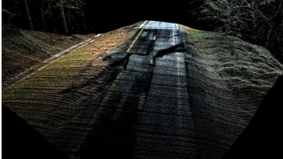
Within the past week, we were contacted by the Alabama Department of Transportation to assist with imaging an area of severe road damage on Alabama 231 caused by heavy rain we have been experiencing. We were first contacted around 11 AM and had the data collected and processed that same evening. The value of adding colourization to the point cloud is clearly evident in Figure 1. This is not a photogrammetric point cloud; it is True View 410 LIDAR data colourized by data from the dual integrated cameras.

Figure 1 – Road damage imaged by True View 410
Drone Mapping Software in Action
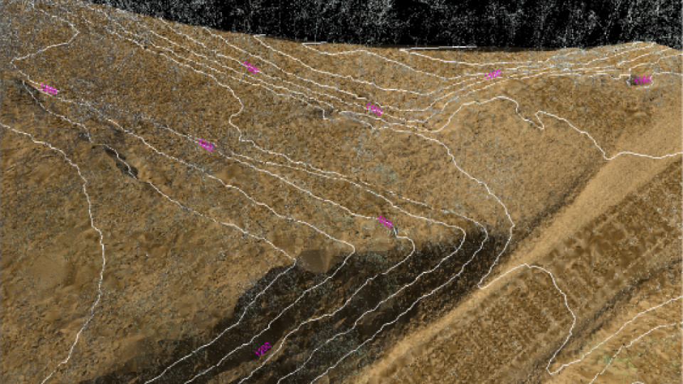
Of course, AL DOT wanted more than just pretty pictures. They needed a classified ground model as well as derivative products, such as a gridded DEM and topographic contours. The capability for generating these products is included in our drone mapping software, True View Evo, the software bundled with a True View 410 sensor. Figure 2 shows a 3D view of a project area, displayed in True View Evo. The ground was classified using, True View Evo’s, automatic ground classification algorithm. The figure shows the ground displayed as a Triangulated Irregular Network (TIN) with non-ground points superimposed. This is a useful view as it leaves objects such as trees standing above the TIN rendering. In addition, we superimposed 10 feet contours over the view. You can appreciate how steep the terrain is in this area!

Figure 2 – Rapid response Terrain Model
Why UAV LIDAR/Imagery Goes Above and Beyond
These several projects have really opened our eyes to the use of the True View 410 in emergency (though I prefer the term “rapid”) response situations. The systems contain a high accuracy APX-15 Position and Orientation System (POS) from Applanix, so direct geopositioning is enabled meaning no ground control is necessary for the accuracies typically required in rapid response. Direct 3D from the LIDAR means no multi-hour photogrammetric point cloud processing. Finally, the integrated cameras mean you get direct colourization of the point cloud, greatly enhancing the ability to visually interpret the data. Of rouse, an additional bonus is that you can collect at night, sans imagery, if necessary (and, of course, you have a waiver permitting the operation).
The use cases for our UAV LIDAR/Imagery sensor, True View 410 continues to multiply. We are extremely pleased with the way this system is being deployed, often in situations, we did not envision during its design. Feel free to send us a note to discuss your ideas on deploying our UAV LIDAR/Imagery system for your project needs.
Related products


