

Tree Inventory
Since adoption of the Urban Forest Master Plan (UFMP) in 2012, the HRM realized that — in order to meet the plan’s canopy targets — it would have to increase its planting volume by several hundreds of trees per year, resulting in a total annual planting of more than 1,000 non-replacement trees. But the use of contractors also came with complications. Primarily, the municipality requires a two-year warranty from contractors, intended both to protect the municipality against premature tree mortality from natural causes, as well as to ensure contractors stand by the quality of their planting. “Contractors must be held accountable,” Simmons said. “But they don’t typically patrol the streets on their own looking for dead trees to replace.” Yet tens of thousands of dollars are on the line when trees require replacement under warranty. “HRM pays the contractor around $400 per tree,” Simmons said. “So it’s important that all tree mortality caused by natural causes is recognized, and replaced, while the tree is still under warranty.” Halifax needed a way to inventory newly planted trees and monitor them individually during the warranty period.
Halifax Students Identify $270,000 Worth of Trees for Replacement by Using Spatial Inventory, the Arrow 100 and Esri Collector
BY EOS POSITIONING SYSTEMS / MONDAY, 26 NOVEMBER 2018 / PUBLISHED IN LATEST NEWS, NEWS, SUCCESS STORIES

Students from Dalhousie University help Halifax Regional Municipality (HRM) maintain and monitor an inventory of more than 8,000 urban street trees. In doing so, they enable the municipality to track survivorship, identify valid warranty replacements, and mitigate future risks.
About the Researchers: Dalhousie University’s School for Resource and Environmental Studies
Dalhousie University’s School for Resource and Environmental Studies (SRES) has been studying urban forests under the leadership of Dr. Peter Duinker for over a decade. One of their well-known projects includes co-authoring the Halifax Regional Municipality’s (HRM) Urban Forest Master Plan (UFMP).
Since the publication of the UFMP and its subsequent approval by HRM Regional Council, students and other researchers from SRES have been working closely with municipal urban forest and planning staff to support and monitor implementation of the UFMP.
This has included annual inventory of new contractor-planted trees, assessment of survivorship of trees and damages to public trees, participation in citizen- and NGO-led plantings and other educational events, and more.
Students and other researchers from SRES have been working closely with municipal urban forest and planning staff to support and monitor implementation of the Urban Forest Master Plan.
![]()

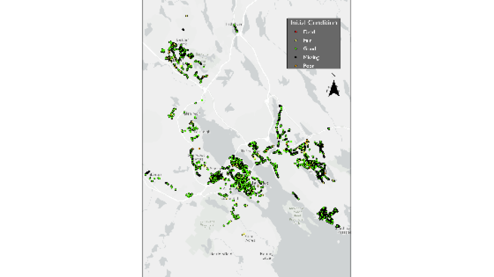
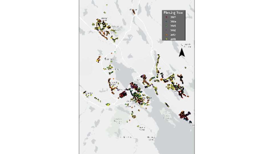
Areas covered within the Urban Forest Master Plan
About the Challenge: Meeting Immediate and Long-Term Needs for Urban Forestry Management
Since adoption of the Urban Forest Master Plan (UFMP) in 2012, the HRM realized that — in order to meet the plan’s canopy targets — it would have to increase its planting volume by several hundreds of trees per year, resulting in a total annual planting of more than 1,000 non-replacement trees.
That number would be unprecedented in Halifax, where prior to 2013, annual tree plantings were performed primarily to replace losses in the urban canopy. That amount of trees was manageable for staff. Without the in-house capacity to plant so many new trees, HRM would need to hire contractors.
“The use of contractors allows us to pursue a more aggressive planting program,” former HRM Urban Forest Superintendent John Simmons said.
But the use of contractors also came with complications.
Primarily, the municipality requires a two-year warranty from contractors, intended both to protect the municipality against premature tree mortality from natural causes, as well as to ensure contractors stand by the quality of their planting.
“Contractors must be held accountable,” Simmons said. “But they don’t typically patrol the streets on their own looking for dead trees to replace.”
Yet tens of thousands of dollars are on the line when trees require replacement under warranty.
“HRM pays the contractor around $400 per tree,” Simmons said. “So it’s important that all tree mortality caused by natural causes is recognized, and replaced, while the tree is still under warranty.”
Halifax needed a way to inventory newly planted trees and monitor them individually during the warranty period.
But identifying the same tree year after year, let alone thousands, was no small undertaking.

Since adoption of the Urban Forest Master Plan (UFMP) in 2012, Halifax Regional Municipality realized that it would have to increase its planting volume by hundreds of trees per year, resulting in a total annual planting of more than 1,000 non-replacement trees.
“HRM pays the contractor around $400 per tree, so it’s important that all tree mortality caused by natural causes is recognized, and replaced, while the tree is still under warranty.”
— John Simmons, Former HRM Urban Forest Superintendent
About the Project: Inventorying Urban Forestry Under an Ambitious Plan
The UFMP called for HRM to collaborate with Dalhousie University in order to achieve two core goals:
- First, pursuit of neighbourhood-level canopy targets through increased planting
- And second, ongoing urban forest research enabling informed management decisions by HRM
Both Dalhousie University and HRM believed that an inventory of newly planted trees would be critical to satisfying these needs. Therefore, in the summer of 2013, students from SRES began the process for inventorying every single tree newly planted by contractors in HRM.
But finding the optimal field workflow took five years and the patience to overcome several limitations inherent to academia, forestry, and field technology.
How Interns Performed a Year of Fieldwork in Just Four Months
HRM grants an annual contract with SRES to hire two graduate-student interns per summer for work related to the UFMP implementation. These interns inventory new trees and revisit trees that fall within the warranty period to assess their survivorship.
The students’ work begins once a contractor plants a new tree. They visit the tree initially to record its location as well as important information about its origins, condition, and surroundings. A typical data capture would include:
- Planter’s Identity
- Submeter Location (i.e., GNSS coordinates and metadata)
- Relative Location (i.e., tied to a civic address)
- Species
- Diameter (at breast height)
- Condition
- Proximity to the curb
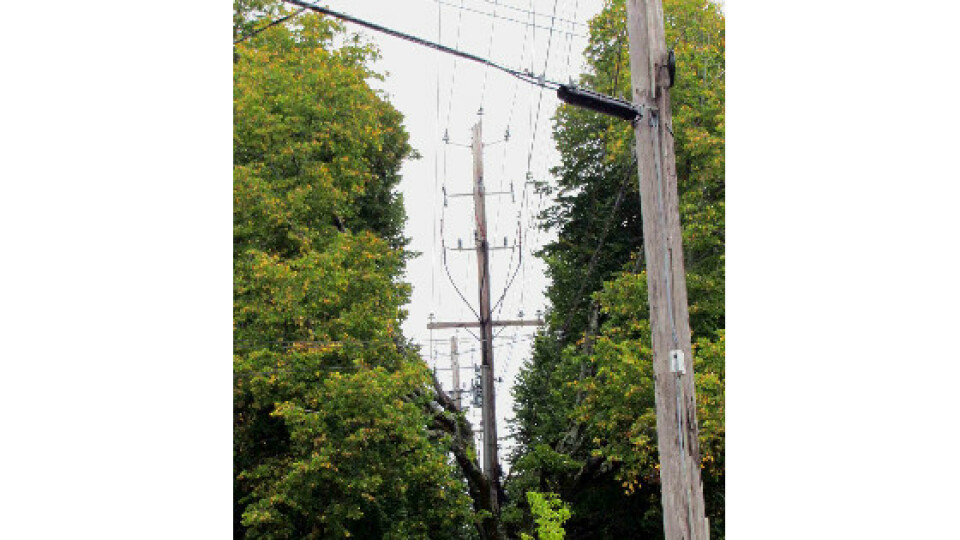
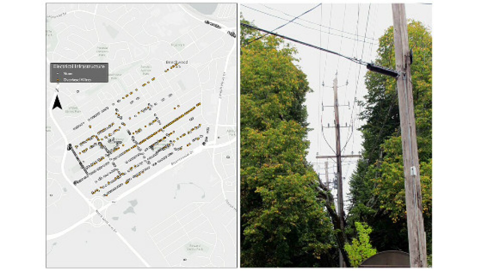
- Overhead Wire Presence (and type)
“It is a tall order for two students to complete all of this data collection for over a thousand trees within the span of four months,” said Dr. Duinker, who mentors the interns. “Efficiency is key in their day-to-day operations.”

David Foster
“We had instances, especially in large medians where there were lots of trees, where we were unable to determine which tree was which, based on the inventory.”
— David Foster, Former SRES Intern and Current Dalhousie University Ph.D Student
Watch David Foster present his work at the 2018 Esri Canada User Conference in Fredericton:
Legacy Workflow
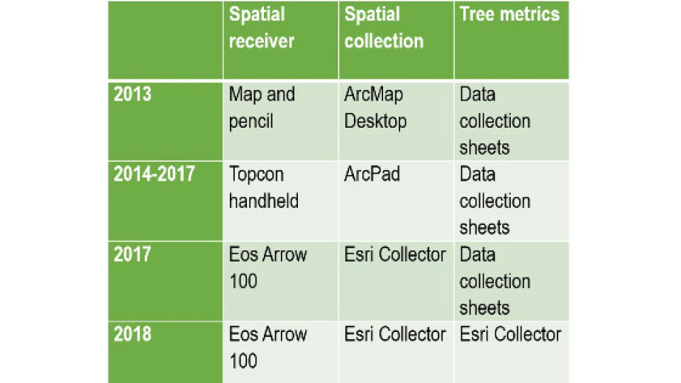
In the beginning, the students conducted their fieldwork with now-legacy handheld devices manufactured by a major GNSS brand. These all-in-one units provided a more or less precise GNSS spatial location of each tree, which was required to allow next year’s students to return to the correct tree to monitor its health.
“These units provided good accuracy, but it was difficult to enter all the other data, like location relative to civic addresses or other landscape features,” former SRES intern David Foster said. Foster is currently a PhD student studying forest management and hydrology at Dalhousie. “So, we used a pen and paper to collect all the other information.”
This workflow became time consuming not just in the field, but also back in the office, where data had to be re-entered into the database.
“The workflow was quick in the field but time-consuming later on,” former SRES urban forest intern Kelsey Hayden said. “The data had to be manually entered into the computer, and that created the possibility of data-entry errors.”
In addition, the legacy devices were aging, which made them increasingly prone to shutdowns. When this happened, some students said the units were “practically unusable” because they required additional time to re-establish connection to the GNSS differential correctional services.
“If the device had to be restarted for any reason, we had to wait in the field,” Hayden said.
In addition, the all-in-one units struggled to provide a reliable accuracy in challenging GNSS environments, such as underneath dense canopy.
“We had instances, especially in large medians with lots of trees, where we were unable to determine which tree was which, based on the inventory,” Foster said. “If the previous data-collector had been having a bad day, the spatial inventory was rarely of much help.”
These inefficiencies were considered “unacceptable” for both SRES and HRM staff’s standards.
They looked for a better field workflow that sped up the interns’ data collection while addressing some of the inaccuracies.

Student collection methods since the start of their annual forestry inventorying
“The workflow was quick in the field but time-consuming later on. The data had to be manually entered into the computer, and that created the possibility of data-entry errors.”
— Kelsey Hayden, Former SRES Urban Forest Intern
About the Solution: Spatial Inventory and the Arrow 100 with Collector on Android

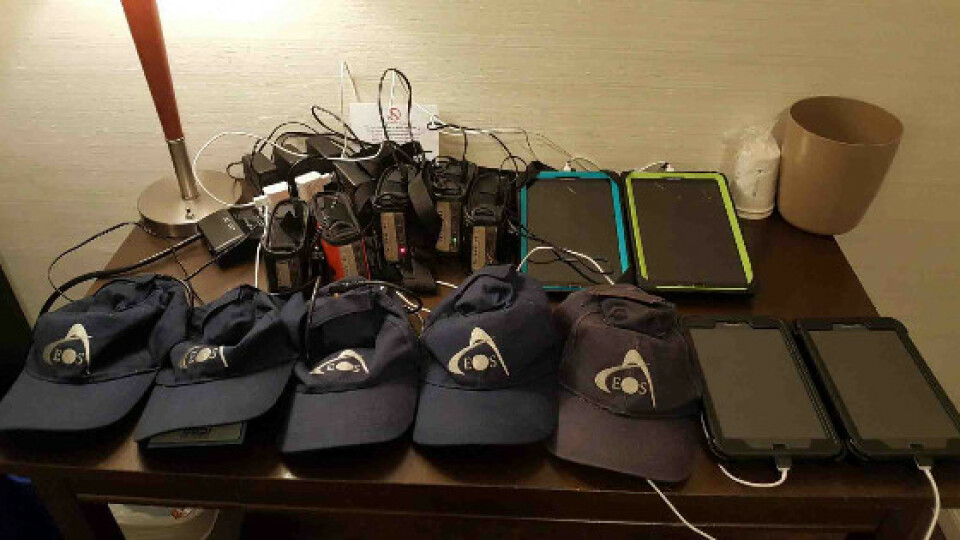
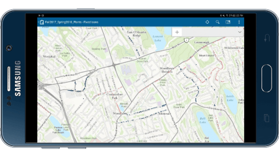
Students switched to a faster workflow on Android tablets, which they connected to high-accuracy GPS receivers (the Arrow 100) via Bluetooth. They then collected tree-inventory data by using Esri's Collector for ArcGIS mobile app.
First, to handle their high-accuracy location needs, the SRES team looked for an accurate external GNSS (GPS) receiver. By having an external GPS instead of an all-in-one device, the students could avoid complete shutdowns in the field. If their Android tablets failed, for instance, the GNSS receiver would continue acquiring high-accuracy locations until the tablet restarted. They could then resume their work without any further downtime. They chose the Bluetooth® Arrow 100 GNSS receiver from Eos Positioning Systems® because it provided the high accuracy, simplicity, and efficiency required, along with an increased level of productivity under canopy.
“One of the most valuable things we find about the Arrow 100 is that if our phone or tablet is having a bad day, we don’t have to worry about losing that precious location lock that can take a while to obtain,” Foster said. “Working on a limited budget, we also saw incredible value in the Arrow 100’s use of the free WAAS differential correction signal to provide submeter accuracy instead of having to subscribe to a paid, local RTK network.”
To simplify data collection, SRES started using Esri’s Collector for ArcGIS® mobile app for map-based data collection. Collector allowed multiple users on different devices to edit a single feature layer at the same time. This meant two teams of students could update the inventory independently. Collector’s drop-down menus further accelerated the data collection. Moreover, the app worked both online, connected in real time to the ArcGIS server, and offline, disconnected, with a data sync performed once wifi was available. With the external GNSS receiver and Collector set up on Android tablets, the students were able to collect sub-meter accurate data in most of urban HRM.
“The receiver only struggled to obtain sub-meter accuracy in highly built-up areas, where tall buildings obstruct well over 60-70% of the sky,” Foster said. “All GNSS receivers will struggle when there is no clear view of the sky. In these instances, an imagery base-layer in Collector allowed the students to manually place points on the map with reasonable accuracy.”
Today, the students’ pace has become rapid. In just 25 field days this past summer, they visited over 2,100 trees for inventorying and follow-up monitoring. That’s an average of over 84 trees per day. On their most productive day, they measured 228 trees.
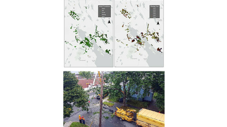
Trees can now be assessed every year for the two years of the warranty period. During a rapid drive-by inspection, a close collaboration between three stakeholders allows identification of the trees that need to be replaced under warranty. First, the students use the previously created spatial inventory on Collector to direct a municipal arborist, and the original contractor, to the right trees. The arborist then points out any trees requiring replacement, while the student makes notes on the corresponding trees in Collector. This method allows the them to assess the survivorship of hundreds of trees per day.
Arrow 100 receivers with Android tablets
LEARN MORE ABOUT THE ARROW 100

Trees were mapped in real-time with submeter accuracy using Esri's Collector for ArcGIS, Arrow 100, and Samsung tablets.
LEARN MORE ABOUT USING COLLECTOR FOR ARCGIS WITH ARROW
“One of the most valuable things we find about the Arrow 100 is that if our phone or tablet is having a bad day, we don’t have to worry about losing that precious location lock that can take a while to obtain.”
— David Foster, Former SRES Intern and Current Dalhousie Ph.D Student
To read the rest of this article, click here ...
GNSS
Esri
forestry
ArcGIS
Collector
iPad
GIS
GPS
Arrow 100
urban forestry
Android
Field data collection
mobile gis
ease of use
tree inventory
cost savings
Do you have questions about this case study?
Get in touch with Eos Positioning Systems, and they would be happy to answer any questions you have about pricing, suitability, availability, specs, etc.

Related products


