Topocad – the software that adapts to the user
To work effective, the software needs to keep up with the technical development and be able to handle large amounts of data. That is one of the reasons why the region manager at Teodoliten Mätteknik, Ali Afsahi, has chosen to work with Topocad. The software adjusts to the way I think, he says.

The construction industry is red-hot right now and in Gothenburg, several efforts are up and going. The Old town, Gamlestaden, is in the middle of a transformation to become a modern district where, among other things, a new travel centre takes place. Teodoliten Mätteknik AB is working with several missions in that project.
The company has about 80 employees, and 30 of them works in Gothenburg where Ali Afsahi is region manager. He’s got 11 years of experience as a surveyor, and he follows the software development of geo data carefully.
Ali Afsahi
– I have been working with a lot of different software systems and I have noticed that not all of the suppliers update after the latest technique.
Ali explains that this is a time when the need for certain data increases and the more data that is being added, the more complex does the underlay get. It is then important to be able to work in an environment that can handle it, he says. That is one of the reasons they have chosen to work with Topocad.
– We can see that the developers at Adtollo is aware of what happens in the world and they are adjusting the software system accordingly. You can see a clear line between the versions that has been released, that the software gets more advanced and more responsive to our needs.
One example that Ali mentions is that Topocad can handle large drawings. He also points out the importance of choosing the right computer and graphic card that can handle the large amount of data.
Understanding of how the software works
Ali has used four different software systems when he finally concluded that it is Topocad they should use in the projects. One word he uses a lot is simple.
– Topocad is simple to work with and less button presses are needed, which makes it faster to deliver a message in terms of a drawing.
The interface is clear at surveying and presentation, and there are functions both as text and symbols. It is easy to understand how the software works and how to navigate in it.
Ali gives an example when the points should be staked out in the construction area.
– Then I start with downloading a drawing from a project portal and it is easy to transform it to the correct coordinate system. Adtollo has made this process very simple if you compare to other software systems. I can also transfer the information to other reference systems. Then I choose the layers that I want to work with, recode the layers and export the information directly to my tablet. Done!
The way of working gets intuitive, Ali explains.
– The software system adjusts to the way I think, and to what I want to do, and it catches my interest and attention.
A good cooperation is of course necessary to get the process as efficient as possible. The exchange works satisfying and also when he imports data. Everything is included, such as symbols and lines. The exchange with AutoCAD also works great which is a plus, says Ali.
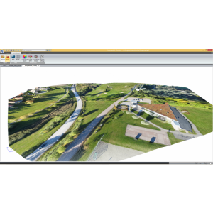
In Gamlestadens travel centre, Topocad is used to measure details in the area, such as pipes and wells. Data is also used to, for example, create profile forms to show height differences between the pipes. Ali is doing this using the Geometry Module in Topocad. Data is also collected as a foundation for excavation and sectioning. By using the profile forms, Ali can do simple projections. Not in this project though.
Attribute makes it easier
Symbols are added to enrich the drawing. Ali then enters an important thing that he would like to put forward: To use attributes.
– It seems like many people in this industry doesn’t use attributes. This is something that needs to be observed, since the work gets much more easy. The knowledge seems low. It is mostly the planner that works with the attributes. The surveyor is perhaps not as interested.
The attributes ease the daily work, Ali thinks.
– The contractors will get all the information they need by exporting it to pdf.
The information can also be compiled in an explanation list in the pdf.
Though, there may be a risk that the information is separated from the drawing when the list is used, and there may be a misunderstanding if the data is not in the exact position as the detail. Data can be placed wrong when the working speed is high, especially when you don´t have much time.
Ali means that this may be related to the way you chose to work. Data is what carries the drawing, the model or the diagram. Effective and structured methods are to wish. That would increase the control of the workflow in the projects, for example when the new travel centre in Gamlestaden becomes reality.


