Store, Process and Visualize Large Datasets in Real-time Mapping Cloud
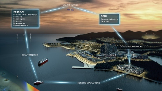
Today’s workflow is very much structured around collecting data offshore and performing processing and analysis of this data once the vessel is docked to shore. This imposes limitations with respect to collection and use of resources in general. To solve this, Kongsberg – a provider of technical products and services to collect various types of data to map the seafloor – has introduced a cloud-based platform called Kognifai.
The aim of this open digital ecosystem is to level the playing field so that everyone can participate, customers, partners, independent software vendors (ISVs), industry clusters and entrepreneurs – to ensure the best possible analysis of collected data. The platform is open to everyone who wants to contribute and transform the industry through digitalization. Kognifai enables sonar data collected with multibeam echosounders and other sensor systems to be stored and managed in a secure environment
Kognifai
Kognifai is Kongsberg’s solution for a truly open cloud-based digital environment. Kognifai supports collaboration and knowledge sharing between and within organizations, enabling them to interact with each other in ways never previously considered possible. Through the platform, customers, clients, academia, domain experts and developers can all participate in finding good solutions to common problems.
Large datasets can be stored in Kognifai. The user exclusively owns all data uploaded to Kognifai unless otherwise arranged, and nobody else can read or make use of it unless the user grants them access. Additionally, access can be restricted to a user or a group of users, for a limited time or for a particular purpose. Large datasets make machine learning possible, providing the customer allows access to the data. Secure storage, secure archiving and hybrid cloud solutions are all available.
Kognifai runs on Microsoft Azure, which makes it easy for developers to create compatible applications. In addition, Kongsberg Digital offers several software development kits (SDKs) to further assist in software development. Since these SDKs provide excellent examples to show how common tasks are easily solved, the road to deploying applications in Kognifai is relatively easy for most developers. The Kognifai portfolio also contains edge connectors, 3D tools, application framework support, authentication and authorization systems, dashboard widgets, database solutions, routing and queue support features.

Figure 1: Kognifai – Kongsberg’s open digital environment.
Mapping Cloud
The first application Kongsberg has deployed in the Mapping Cloud solution is Storage. To ensure ease of use, Storage looks like a file manager on a PC. However, there are a few additional Storage tricks:
-
Data upload. The file manager has cloud connectors that can be installed on ships, automatically pushing data to the cloud. It also makes it easy to copy large volumes of data from an office PC to data storage in Kognifai.
- Data sharing between Kognifai users. Others may be allowed to read data, process it and upload the new results. This is performed in a few clicks; there is no need to send physical hard drives or set up FTP servers to share large volumes of data between clients.
- Archiving. Data stored in Microsoft can be ‘hot’, in which case data can be accessed immediately like a hard drive. However, this has a higher cost than ‘cold’ storage. Cold storage is great for saving money when storing large data volumes that do not have to be online at all times.
‘Virtual PCs’ are also available in Kognifai. Users can install existing processing software and process the data just like before. This solution makes it easy to benefit from using a cloud solution – collaboration between several people during the processing, distribution of the results to clients and customers, access from any geographical location – while still using familiar software.
Figure 2: Mapping with processing software.
Remote Operations
Remote control of Kongsberg multibeam echosounders is now part of Mapping Cloud. The survey vessel can do real-time data processing and send only the necessary data to Mapping Cloud via any internet carrier: satellite, 4G, Wi-Fi, MBR. The user can control how much data to send from the ship into Mapping Cloud. The two-way communication enables the operator in Mapping Cloud to set specific parameters in the mulibeam echosounders in real time.
Mapping Cloud differs from many other cloud solutions in that it is a truly open digisystem; anyone can create a Mapping Cloud account, and any kind of data can be uploaded and stored there.
One recent project between Kongsberg Maritime, iSURVEY and Earth Analytics demonstrated how real-time information from tug boats and an oil rig can be sent to Mapping Cloud, processed and then passed on for display in Google Chrome. The tracks of the tug boats show how they move to place the anchors for the oil rig at the correct locations. EIVA NaviPac is used to acquire the positions from the vessels and then passed on to Mapping Cloud.
Data sent to Mapping Cloud in near real time can be made available to third-party software vendors for additional processing and display. In these cases, Mapping Cloud is used as a base station for data storage and distribution, and additional processing for quality enhancement. Earth Analytic, a Kongsberg partner, has demonstrated how to integrate real-time data into map services and improve situation awareness. Cloud-to-cloud connection is also possible, allowing a seamless data flow from Mapping Cloud into other systems such as PostgreSQL databases and further processing in ArcGIS.
Stronger together
Kongsberg’s Windmill control system is already powered by Kognifai. Future development will continue in the integration between Kognifai’s and ESRI’s cloud solutions. Interfaces between the two clouds will be standardized, more data types will be made available (depths, sidescan, processed water column measurements, terrain models, real-time data), and new processing tools will be developed. The need for video management software (VMs) will decrease as new applications will be web applications in the cloud, taking full advantage of the extended possibilities cloud computing has to offer: multiple cores, RAM, and all this available when needed.
Acknowledgments
Thanks go to Audun Berg, vice president MPC, Kongsberg Maritime Subsea, Sverre Tetlie, product line manager MPC,
Kongsberg Maritime Subsea, and Christian Møller, senior vice president & CTO, Digital Platform Technology, Kongsberg Digital.
About the Author
Terje Haga Pedersen is Prodoct manager at Kongsberg Maritime Subsea Mapping, Positioning and Communication (MPC), Norway
Do you have questions about this case study?
Get in touch with Kongsberg Discovery, and they would be happy to answer any questions you have about pricing, suitability, availability, specs, etc.
Related products


