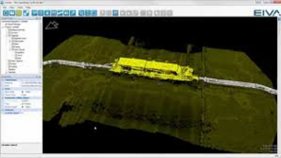
Shallow Water Surveys with NaviModel Hydrographic Processing Software
Advanced sensor data acquisition and processing software solution at an affordable price The NaviSuite Kuda solution offers all the relevant features for carrying out shallow water surveys at an affordable price.
Combine laser and multi-beam echo sounder data in NaviModel
NaviModel allows you to combine subsea and above-water laser data with multi-beam echo sounder data. This means that you can carry out surveys covering for example harbour structures both above and below sea level in one survey.
If you're having trouble with the resolution of the video, click the settings icon and choose Quality to change it
Laser intensity tool in NaviModel
When working with laser data, the software must be able to handle high intensity values and adjusting settings to match the sensor technology. This is ensured with a new intensity control tool allowing you to adjust the intensity scale to match the data output and the relevant intensity scale. Thereby, point clouds with high intensity data are presented with a much higher level of detail in NaviModel.
If you're having trouble with the resolution of the video, click the settings icon and choose Quality to change it
Live laser acquisition and digital terrain model in NaviScan
NaviScan allows for live quality control during sonar and laser data acquisition via completely 3D motion-compensated data visualisation in real time.
If you're having trouble with the resolution of the video, click the settings icon and choose Quality to change it
Sensor and sonar data editing in NaviEdit
NaviEdit offers data editing of all recorded sensors and sonars. When a sensor value is edited, this has an immediate effect on related data.
If you're having trouble with the resolution of the video, click the settings icon and choose Quality to change it
Side-scan waterfall in NaviScan SonarDisplay with targets
The NaviScan SonarDisplay enables you to control seabed detection and intensity colour palette as well as identify and mark targets and calculate their approximate dimensions.
If you're having trouble with the resolution of the video, click the settings icon and choose Quality to change it
Runline handling in NaviPac
NaviPac allows you to create runlines with the mouse while displaying user guides on-the-fly. Together with easily created parallel and cross lines, this makes for efficient survey operations.
If you're having trouble with the resolution of the video, click the settings icon and choose Quality to change it
Easy configuration in NaviPac
NaviPac includes an intuative tool for setting up your entire survey sperad, from geodesy to detailed sensor integration.
If you're having trouble with the resolution of the video, click the settings icon and choose Quality to change it
Free drawings in NaviPac
NaviPac allows for use of background and vessel shape files. You can load 2D and 3D drawings of vessel outline based on the standard drawing library 3DS (the software includes some sample files). The Helmsman's Display of NaviPac also includes a free world map (world shore lines) for low resolution charts. Moreover, NaviPac supports the use of a series of web services such as Bing Maps.
If you're having trouble with the resolution of the video, click the settings icon and choose Quality to change it
AutoCAD drawings in NaviPac
You can load a series of standard file formats into NaviPac as background information for a more comprehensive data overview. This includes GEO-coded images (for example charts, fotos or mosaic), NaviModel terrain models (DB files), ESRI shape files (SHP) and AutoCAD DXF files (2D and 3D).
If you're having trouble with the resolution of the video, click the settings icon and choose Quality to change it
Digital terrain model in NaviPac – also in real time
NaviPac allows you to create a digital terrain model based on real-time or previous sensor and sonar data on top of naval chart overlays (CMAP/JEPPESEN/7C/S57) in the Helmsman’s Display. Through this visualisation of the coverage in real time, you get safety guidance, optimal data quality control and efficient survey route planning.
If you're having trouble with the resolution of the video, click the settings icon and choose Quality to change it
Generic data display in NaviPac
The Data Monitor module in NaviPac offers an advanced display for hydrographic survey data monitoring with easy configuration and simple yet comprehensive presentation of sensor data through intuitive visual modelling.
If you're having trouble with the resolution of the video, click the settings icon and choose Quality to change it
User-defined layout in NaviPac
The NaviPac Helmsman's Diplay offers dockable windows, floating windows, auto-sizing and window templates for ease of use and fast customisation of the displayed data.
If you're having trouble with the resolution of the video, click the settings icon and choose Quality to change it
User-defined data view in NaviPac
The NaviPac Helmsman’s Display offers real-time sensor and sonar data acquisition view, multiple waypoint view and runline tracking combined in a single display.
If you're having trouble with the resolution of the video, click the settings icon and choose Quality to change it
Do you have questions about this case study?
Get in touch with EIVA, and they would be happy to answer any questions you have about pricing, suitability, availability, specs, etc.
Related products

![3月21日-封面[1].jpg](https://cdn.geo-matching.com/voeE1ywo.jpg?w=320&s=6b3b1a0215d770f8797653e9202a8f52)


