
OxTS - What is an INS / LiDAR boresight misalignment and why is it a problem?
Conducting a LiDAR survey takes a lot of preparation and meticulous planning. It is important therefore to ensure that nothing is left to chance when going out into the field. Boresight misalignment is one thing that can stall operations and lead to poor results, so careful consideration needs to be made about how to overcome the problem. Here we explain exactly what boresight misalignment is and why it's such an issue.
What is Boresight Misalignment?
A boresight misalignment occurs when there is an imprecision in the angles measured between you tracking device (INS) and your surveying device (LiDAR). Small errors in your heading, pitch and roll angles are often unimportant when you are only considering your own position but when you are surveying objects some 10-100 meters away a tiny angular imprecision causes significant if not fatal distortions in your data.
It is therefore crucial to measure these angles as precisely as possible (to around 0.1°) and this is often impossible by eye or using physical measuring devices.
Why is it a problem?
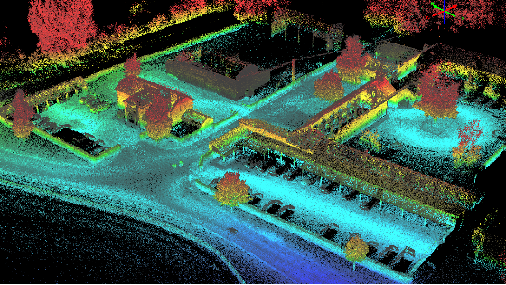
When you try to view an object it will have a position and orientation dependent on where you are viewing it from. It will appear displaced and distorted. When you survey the same object from several directions you get a blurring effect. This will make distance and volume measurements inaccurate and in the worst case impossible.
As a quick calculation, if you have an error in one axis of just 0.2° then for a point 10m away there will be a position error of approximately -
0.2 ×2360×2π×10≃7cm .
.
So what is the Solution?
To correct these angles we need to take a data-driven approach to boresight calibration.
In effect. The boresight calibration is a data-driven calibration technique for getting the angles between your INS and LiDAR accurate to tenths of a degree whereas other methods might not even achieve half a degree accuracy and this alone can significantly distort the final Pointcloud.
The OxTS Georeferencer software does the hard work for you, all you need to do is view some targets with the LiDAR in a 5 minute process that can be added onto any survey run.
For more information on boresight misalignment and calibration you can watch our webinar on the subject HERE
OxTS are suppliers of highly accurate Inertial Navigation Systems for UAV, Mobile and Aerial mapping applications.
Do you have questions about this article?
Get in touch with Oxford Technical Solutions - OxTS, and they would be happy to answer any questions you have about pricing, suitability, availability, specs, etc.


